
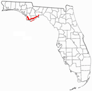
Franklin County is a county along the Gulf of Mexico in the panhandle of the U.S. state of Florida. As of the 2010 census, the population was 11,549, making it the third-least populous county in Florida. The county seat is Apalachicola.

Apalachicola is a city and the county seat of Franklin County, Florida, United States, on the shore of Apalachicola Bay, an inlet of the Gulf of Mexico. The population was 2,231 at the 2010 census.

The ACF River Basin is the drainage basin, or watershed, of the Apalachicola River, Chattahoochee River, and Flint River, in the Southeastern United States.
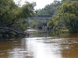
The Apalachicola River is a river, approximately 160 mi (180 km) long in the state of Florida. The river's large watershed, known as the ACF River Basin, drains an area of approximately 19,500 square miles (50,500 km2) into the Gulf of Mexico. The distance to its farthest head waters in northeast Georgia is approximately 500 miles (800 km). Its name comes from the Apalachicola people, who used to live along the river. It is the largest river in Florida.

The Florida Panhandle is the northwestern part of the U.S. state of Florida; it is a strip of land roughly 200 miles (320 km) long and 50 to 100 miles wide, lying between Alabama on the north and the west, Georgia on the north, and the Gulf of Mexico to the south. Its eastern boundary is arbitrarily defined. In terms of population, major communities include Tallahassee, Pensacola, and Navarre.

The shoal bass is a species of freshwater fish in the sunfish family (Centrarchidae) of order Perciformes. One of the black basses, it is native to subtropical waters in Florida and Georgia. It is also occasionally found in rivers and streams of East Alabama where it has been declared an endangered species and cannot legally be kept if caught by fishermen. Of typical size for a black bass, M. cataractae reaches a maximum recorded length of 24 inches (61 cm) and a maximum published weight of 8 pounds, 12 ounces.

Tarkiln Bayou Preserve State Park is a 4,290-acre (17.4 km2) preserve, a unit of Florida State Park located 10 miles (16 km) southwest of Pensacola, in northwestern Florida. It is home to four species of endangered pitcher plants, as well as other rare and endangered plant species. The rare, carnivorous white–top pitcher plant is unique to the Gulf Coast and found only between the Apalachicola and Mississippi rivers. Almost 100 other rare plants and animals depend on the wet prairie habitat, including the alligator snapping turtle, sweet pitcher plant, and Chapman's butterwort. Tarkiln Bayou Preserve State Park is located in Escambia County about 1.5 miles (2.4 km) south of the intersection of U.S. Hwy. 98 and State Road 293.

Torreya State Park is a 13,735 acre (56 km²) Florida State Park, United States National Natural Landmark and historic site thirteen miles (19 km) north of Bristol. It is located north of S.R 12 on the Apalachicola River, in northwestern Florida, at 2576 N.W. Torreya Park Road.

The Apalachicola National Forest is the largest U.S. National Forest in the state of Florida. It encompasses 632,890 acres and is the only national forest located in the Florida Panhandle. The National Forest provides water and land-based outdoors activities such as off-road biking, hiking, swimming, boating, hunting, fishing, horse-back riding, and off-road ATV usage.

Apalachicola Regional Airport is a county-owned, public-use airport located two nautical miles (4 km) west of the central business district of Apalachicola, a city in Franklin County, Florida, United States. It is included in the National Plan of Integrated Airport Systems for 2011–2015, which categorized it as a general aviation facility. It was previously known as Apalachicola Municipal Airport. The airport supports general aviation activity in the area and provides service via a tenant fixed-base operator (FBO).

Tate's Hell State Forest is 202,000 acres (819 km²) of land in Franklin and Liberty counties in Florida. The forest is located near Carrabelle off US 98 along the Gulf coast and on St. James Island. At one time, Tate's Hell supported at least 12 major habitats including: wet flatwoods, wet prairie, seepage slope, baygall, floodplain forest, floodplain swamp, basin swamp, upland hardwood forest, sandhill, pine ridges, dense titi swamp thickets and scrub. Tate's Hell State Forest is an important hydrologic area and includes a section of the New River. The park's watershed provides fresh water into the Apalachicola Bay, the Carrabelle River and the Ochlockonee River.

St. Vincent Island is the westernmost of 4 barrier islands in the northwestern Florida Gulf coast which include Cape St. George Island, St. George Island and Dog Island. St. Vincent Island is located just offshore in Franklin County, Florida south southeast of Cape San Blas and north of Cape St. George Island close to the mouth of the Apalachicola River and the town of Apalachicola on the Florida Panhandle.

Apalachicola Bay is an estuary and lagoon located on the northwest coast of the U.S. state of Florida. The Apalachicola Bay system also includes St. George Sound, St. Vincent Sound and East Bay, covering an area of about 208 square miles (540 km2). Four islands, St. Vincent Island to the west, Cape St. George Island and St. George Island to the south, and Dog Island to the east, separate the system from the Gulf of Mexico. Water exchange occurs through Indian Pass, West Pass, East Pass and the Duer Channel. The lagoon has been designated as a National Estuarine Research Reserve and the Apalachicola River is the largest source of freshwater to the estuary. Combined with the Chattahoochee River, Flint River, and Ochlockonee River they drain a watershed of over 20,000 square miles (50,000 km2) at a rate of 19,599 cubic feet (550 m3) per second according to the United States Geological Survey in 2002.
Florida's Forgotten Coast is a registered trademark coined in the early 1990s by the Apalachicola Bay Chamber of Commerce. The name is most commonly used to refer to a relatively quiet, undeveloped and largely uninhabited section of coastline stretching from Mexico Beach on the Gulf of Mexico to St. Marks on Apalachee Bay in the U.S. state of Florida. The nearest major cities are Tallahassee, about 90 miles (145 km) northeast of Apalachicola, and Panama City, home of Tyndall Air Force Base, about 60 miles (95 km) to the northwest.
The Ochlockonee River is a fast running river, except where it has been dammed to form Lake Talquin in Florida, originating in Georgia and flowing for 206 miles (332 km) before terminating in Florida.
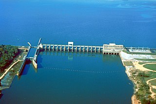
Lake Seminole is a reservoir located in the southwest corner of Georgia along its border with Florida, maintained by the U.S. Army Corps of Engineers. The Chattahoochee and Flint rivers join in the lake, before flowing from the Jim Woodruff Lock and Dam, which impounds the lake, as the Apalachicola River. The lake contains 37,500 acres (152 km2) of water, and has a shoreline of 376 mi (605 km). The fish in Lake Seminole include largemouth bass, crappie, chain pickerel, catfish, striped bass and other species. American alligators, snakes and various waterfowl are also present in the lake, which is known for its goose hunting.
Ochrotrichia apalachicola is a species of microcaddisfly. It is only known from a single adult male collected from a cold spring-fed stream in the Apalachicola National Forest, Florida. This is a tiny brown caddisfly up to 3.4 mm in length and can only be distinguished from its closest relatives by minute differences in the genitalia.
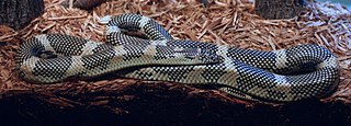
The Apalachicola kingsnake is a non-venomous species of kingsnake found in a small area of the Florida panhandle known as the Apalachicola Lowlands. Long argued as to whether or not it is a subspecies, the Apalachicola kingsnake was formerly named Lampropeltis getula goini. After years of research and many more specimens examined, in 2006 it was renamed to Lampropeltis getula meansi after D. Bruce Means, in recognition of his work on this subspecies.

The Apalachicola National Estuarine Research Reserve, located in the U.S. State of Florida, protects the biological diversity of the Apalachicola Bay as well as the economic value of the natural resources and pristine conditions.
The AN Railway is one of several shortline railroad companies owned by the Genesee & Wyoming parent company. It operates between Port Saint Joe, Florida and a connection with the Florida Gulf & Atlantic Railroad at Chattahoochee, Florida. The railroad no longer reaches its namesake city of Apalachicola, Florida, as the rails have been removed between Franklin and Apalachicola. The railroad operates approximately 96 miles (154 km) of track.