| Høllen Spangereid | |
|---|---|
| Village | |
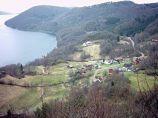
 Høllen Location of the village  Høllen Høllen (Norway) | |
| Coordinates: 58°02′43″N07°08′38″E / 58.04528°N 7.14389°E Coordinates: 58°02′43″N07°08′38″E / 58.04528°N 7.14389°E | |
| Country | Norway |
| Region | Southern Norway |
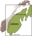
| County | Vest-Agder |
| District | Lindesnes |
| Municipality | Lindesnes |
| Area [1] | |
| • Total | 0.72 km2 (0.28 sq mi) |
| Elevation [2] | 4 m (13 ft) |
| Population (2015) [1] | |
| • Total | 648 |
| • Density | 900/km2 (2,000/sq mi) |
| Time zone | CET (UTC+01:00) |
| • Summer (DST) | CEST (UTC+02:00) |
| Post Code | 4521 Lindesnes |
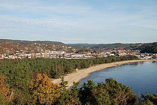
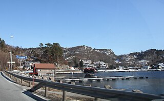
Høllen is a village in Lindesnes municipality in Vest-Agder county, Norway. The village is located on the narrow isthmus connecting the Lindesnes peninsula to the mainland, about 5 kilometres (3.1 mi) west of the village of Svenevig. The 0.72-square-kilometre (180-acre) village has a population (2015) of 648, giving the village a population density of 900 inhabitants per square kilometre (2,300/sq mi). [1]

Lindesnes is a municipality in Vest-Agder county, Norway. It is located in the traditional district of Sørlandet. The administrative centre of the municipality is the village of Vigeland. Other villages in Lindesnes include Åvik, Høllen, Skofteland, Svenevig, and Vigmostad.

Vest-Agder[²vɛstˌɑɡdər](

Norway, officially the Kingdom of Norway, is a Nordic country in Northwestern Europe whose territory comprises the western and northernmost portion of the Scandinavian Peninsula; the remote island of Jan Mayen and the archipelago of Svalbard are also part of the Kingdom of Norway. The Antarctic Peter I Island and the sub-Antarctic Bouvet Island are dependent territories and thus not considered part of the kingdom. Norway also lays claim to a section of Antarctica known as Queen Maud Land.
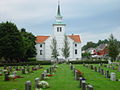
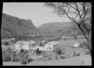
Høllen was the administrative centre of the old municipality of Spangereid which existed from 1889 until 1965. The village is also known as Spangereid since it was the centre of Spangereid for nearly a century and prior to that it was the seat of the parish of Spangereid since Spangereid Church is located in Høllen. [3]
An administrative centre is a seat of regional administration or local government, or a county town, or the place where the central administration of a commune is located.

Spangereid is a former municipality in Vest-Agder county, Norway. The municipality existed from 1889 until its dissolution in 1964. The municipality was located in the southwestern part of the present-day municipality of Lindesnes. The municipality included the whole Lindesnes peninsula, plus part of the mainland adjacent to the narrow isthmus which connects the peninsula to the mainland. The administrative centre was the village of Høllen where the Spangereid Church is located.

Spangereid Church is a parish church in Lindesnes municipality in Vest-Agder county, Norway. It is located in the village of Høllen. The church is part of the Spangereid parish in the Mandal deanery in the Diocese of Agder og Telemark. The white, stone/brick church was originally built in the 1100s. In 1840, the church was expanded and converted into a cruciform design. The church now seats about 300 people.
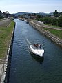
In 2007, the Spangereid Canal was completed through the centre of Høllen. The 0.93-kilometre (0.58 mi) long canal crosses the isthmus connecting the Lindesnes peninsula to the mainland. The canal connects the Lenesfjorden to the North Sea.

An isthmus is a narrow piece of land connecting two larger areas across an expanse of water by which they are otherwise separated. A tombolo is an isthmus that consists of a spit or bar, and a strait is the sea counterpart of an isthmus.

The North Sea is a marginal sea of the Atlantic Ocean located between the United Kingdom, Denmark, Norway, Sweden, Germany, the Netherlands, Belgium and France. An epeiric sea on the European continental shelf, it connects to the ocean through the English Channel in the south and the Norwegian Sea in the north. It is more than 970 kilometres (600 mi) long and 580 kilometres (360 mi) wide, with an area of 570,000 square kilometres (220,000 sq mi).
The area is one of Norway's richest archaeological sites. The abundant remnants from the Bronze Age and Viking age show the Spangereid was a very important place at that time. Today, the village is a popular tourist destination for Norwegians and Europeans alike.

The Bronze Age is a historical period characterized by the use of bronze, and in some areas proto-writing, and other early features of urban civilization. The Bronze Age is the second principal period of the three-age Stone-Bronze-Iron system, as proposed in modern times by Christian Jürgensen Thomsen, for classifying and studying ancient societies.