
Audnedal is a municipality in Vest-Agder county, Norway. It is located in the traditional district of Sørlandet. The administrative centre of the municipality is the village of Konsmo. Other villages in Audnedal include Byremo and Vivlemo. The municipality encompasses the upper half of the Audnedalen valley, and the municipality of Lindesnes covers the southern half of the valley.

Marnardal is a municipality in Vest-Agder county, Norway. It is located in the traditional district of Sørlandet. The administrative centre of the municipality is the village of Heddeland. Other villages in Marnardal include Bjelland, Breland, Koland, Laudal, and Øyslebø.
Mandal (help·info) is a municipality in Vest-Agder county, Norway. It is located in the traditional district of Sørlandet. Mandal is the southernmost municipality in all of Norway, with the tiny skerry of Pysen being the southernmost point of land in Norway.
Fleseland is a small village in Lyngdal municipality in Vest-Agder county, Norway. The village is located on the west shore of the Lenesfjorden, about 10 kilometres (6.2 mi) southeast of the town of Lyngdal and about 6 kilometres (3.7 mi) north of the village of Høllen in Lindesnes municipality.

Krossen is a village in Mandal municipality in Vest-Agder county, Norway. The village is located in the Mandalen valley, on the western shore of the river Mandalselva, about 10 kilometres (6.2 mi) north of the town of Mandal and about 9 kilometres (5.6 mi) south of the village of Øyslebø.
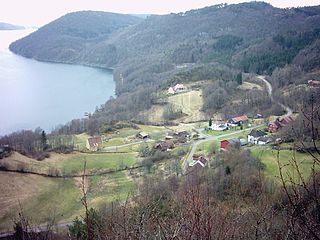
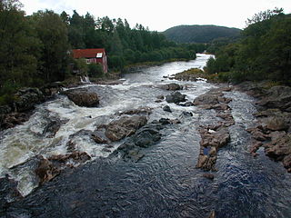
Øyslebø is a village in Marnardal municipality in Vest-Agder county, Norway. The village is located in the Mandalen valley along the Mandalselva river, about 21 kilometres (13 mi) north of the town of Mandal. The Sørlandet Line passes the village to the north, stopping at the Marnardal Station, about 5 kilometres (3.1 mi) north of Øyslebø on the north side of the village of Heddeland. Øyslebø was the administrative centre of the old municipality of Øyslebø which existed from 1899 until 1964.

Vigmostad is a village in Lindesnes municipality in Vest-Agder county, Norway. The village is located along the Audna river in the Audnedalen valley. The village of Konsmo lies about 10 kilometres (6.2 mi) to the north and about 15 kilometres (9.3 mi) north of the village of Vigeland. Vigmostad Church is located in the village.
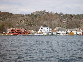
Åvik is a small seaport village in Lindesnes municipality in Vest-Agder county, Norway. The village is on the coast near the southernmost part of Norway, about 2 kilometres (1.2 mi) to the southeast of the village of Svenevig. Åvik sits on the mainland, about 300 metres (980 ft) north of the island of Svinør, and together, the harbours of Åvik and Svinør form one large harbour area. There are many old wooden houses in Åvik.

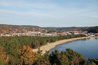
Vigeland is the administrative center of Lindesnes municipality in Vest-Agder county, Norway. The village is located along the river Audna, about 5 kilometres (3.1 mi) north of the river's mouth at the Snigsfjorden. The European route E39 highway runs east-west through Vigeland, connecting it to the town of Mandal, about 12 kilometres (7.5 mi) to the southeast. The 1.19-square-kilometre (290-acre) village has a population (2015) of 1,471 which gives the village a population density of 1,236 inhabitants per square kilometre (3,200/sq mi).

Liknes is the administrative centre of Kvinesdal municipality in Vest-Agder county, Norway. The village is located along the river Kvina, about 5.5 kilometres (3.4 mi) north of the mouth where it empties into the Fedafjorden. The village of Storekvina lies about 7 kilometres (4.3 mi) to the north of Liknes. The 1.97-square-kilometre (490-acre) village has a population (2015) of 2,462 which gives the village a population density of 1,250 inhabitants per square kilometre (3,200/sq mi).
Svenevik is a village in Lyngdal municipality in Vest-Agder county, Norway. The village is located along the Rosfjorden, about 3 kilometres (1.9 mi) south of the town of Lyngdal. The small village of Skomrak is located about 2 kilometres (1.2 mi) straight east across the fjord. The 0.28-square-kilometre (69-acre) village has a population (2015) of 321, giving the village a population density of 1,146 inhabitants per square kilometre (2,970/sq mi).

Snigsfjorden or Sniksfjorden is a fjord in Lyngdal municipality in Vest-Agder county, Norway. The 3-kilometre (1.9 mi) long fjord begins at the mouth of the river Audna by the small village of Snig, about 4 kilometres (2.5 mi) south of the municipal centre of Vigeland. The fjord heads south to the North Sea. The east side of the fjord is the mainland of Norway and the west side of the fjord is bounded by the island of Unnerøy. The two small islets of Fløyholmen and Tolleknivane are located at the mouth of the fjord. The small Navarsundet strait runs between Unnerøy island and the mainland on the west side of the fjord, connecting it to the nearby Syrdalsfjorden.
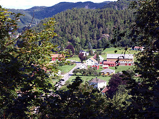
Skofteland is a village in Lindesnes municipality in Vest-Agder county, Norway. The village is located along the river Audna, about 3 kilometres (1.9 mi) northeast of the municipal centre of Vigeland. From Skofteland, there is a road which runs to the northeast to Fuskeland, a small village to the north of the town of Mandal.

Farsund (help·info) is the administrative centre of Farsund municipality in Vest-Agder county, Norway. The town is located near the mouth of the Lyngdalsfjorden, about 5 kilometres (3.1 mi) east of the village of Vanse. The 2.49-square-kilometre (620-acre) town has a population (2015) of 3,265 which gives the town a population density of 1,311 inhabitants per square kilometre (3,400/sq mi). Frelserens Church is the main church for the town.

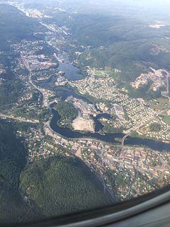
Mandal is the administrative centre of Mandal municipality in Vest-Agder county, Norway. It is the second largest town by population in Vest-Agder county after Kristiansand and the fourth largest town in the Sørlandet/Agder region. The town is located at the mouth of the river Mandalselva at the southern end of the Mandalen valley. The 6.32-square-kilometre (1,560-acre) town has a population (2015) of 10,725 which gives the town a population density of 1,697 inhabitants per square kilometre (4,400/sq mi).
Audna or Audnedalselva is a river in Vest-Agder county, Norway. The 55-kilometre (34 mi) long river runs from the lake Grindheimsvatnet, just north of the village of Byremo in Audnedal municipality, south through the Audnedalen valley to its mouth at the Snigsfjorden in Lindesnes municipality. The mouth is located about 4 kilometres (2.5 mi) southwest of the village of Vigeland. The river has a drainage basin that covers 438 square kilometres (169 sq mi). The river runs through two lakes: Øvre Øydnavatnet and Ytre Øydnavatnet.
Høllen is a village in Lindesnes municipality in Vest-Agder county, Norway. The village is located on the narrow isthmus connecting the Lindesnes peninsula to the mainland, about 5 kilometres (3.1 mi) west of the village of Svenevig. The 0.72-square-kilometre (180-acre) village has a population (2015) of 648, giving the village a population density of 900 inhabitants per square kilometre (2,300/sq mi).
Vennesla is the administrative centre of Vennesla municipality in Vest-Agder county, Norway. The village is located in the upper Torridal valley along the river Otra, about 15 kilometres (9.3 mi) north of the city of Kristiansand. The village itself extends for about 10 kilometres (6.2 mi) along both sides of the river. The Norwegian National Road 9 passes through Mosby, about 6 kilometres (3.7 mi) south of Vennesla. The Sørlandsbanen railway line passes through Vennesla, stopping at Vennesla Station. The lake Venneslafjorden is located on the river Otra in the northern part of the village of Vennesla.


