IXL, Oklahoma

Last updated

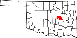
IXL (or I.X.L.) is an historical freedmen's town [1] in Okfuskee County, Oklahoma, United States. [2] While founded perhaps as early as 1900, [1] it was only incorporated in 2001 [3] and had an estimated population of 59 in 2007. [4] The population was 59 at the time of the 2020 census. [5]

The source of IXL's unusual [6] name is disputed. A 2012 article on the town's website explained that the name derived from Indian Exchange Land, a reference to the town being on Mvskoke land. [7] Other sources claim that the letters were taken from the names of three men. [1] [8] Some people think it’s an onomatopoeic boast suggesting "I excel." [9]

This town should not be confused with Oklahoma towns in Kay County and Tillman County which also bears the "IXL" name. [1] Around 1926, Julius Rosenwald Fund provided a grant in the amount of $1,100 for the community to build a school building for the IXL District 12. The school was segregated for grades one through eight. [1]

Demographics

Historical population
CensusPop.Note
2010 51
2020 5915.7%
U.S. Decennial Census [10]

Related Research Articles

<span class="mw-page-title-main">Okfuskee County, Oklahoma</span> County in Oklahoma, United States

Okfuskee County is a county located in the U.S. state of Oklahoma. As of the 2020 census, its population was 11,310. Its county seat is Okemah. The county is named for a former Muscogee town in present Cleburne County, Alabama, that in turn was named for the Okfuskee, a Muscogee tribe.

<span class="mw-page-title-main">Wilmington, New York</span> Town in New York, United States

Wilmington is a town in Essex County, New York, United States. The population was 1,253 at the 2010 census. The town is named after the nearby town of Wilmington, Vermont.

<span class="mw-page-title-main">Matamoras, Ohio</span> Village in Ohio, United States

Matamoras, also known as New Matamoras, is a village in Washington County, Ohio, United States, along the Ohio River. The population was 702 at the 2020 census. It is part of the Marietta micropolitan area.

<span class="mw-page-title-main">Shady Point, Oklahoma</span> Town in Oklahoma, United States

Shady Point, sometimes referred to as Shadypoint, is a town in Le Flore County, Oklahoma, United States. It is part of the Fort Smith, Arkansas-Oklahoma Metropolitan Statistical Area. The population was 1,026 at the 2010 census, a 21.0 percent increase over the figure of 848 recorded in 2000.

<span class="mw-page-title-main">Louisville, Tennessee</span> Town in Tennessee, United States

Louisville is a suburban town in Blount County, Tennessee. Its population was 4,384 at the 2020 census. It is included in the Knoxville, Tennessee Metropolitan Statistical Area.

<span class="mw-page-title-main">La Grange, Tennessee</span> Town in Tennessee, United States

La Grange is a town in Fayette County, Tennessee, United States. The population was 133 at the 2010 census. A large area in the town is listed on the National Register of Historic Places as La Grange Historic District.

<span class="mw-page-title-main">Centerville, Tennessee</span> Town in Tennessee, United States

Centerville is a town in Hickman County, Tennessee, United States. The population was 3,489 as of the 2020 Census. It is the county seat and the only incorporated town in Hickman County. It is best known for being the hometown of American comedian Minnie Pearl.

<span class="mw-page-title-main">Hohenwald, Tennessee</span> City in Tennessee, United States

Hohenwald is a city in and the county seat of Lewis County, Tennessee. The population was 3,757 at the 2010 census. The name "Hohenwald" derives from German meaning “High Forest".

<span class="mw-page-title-main">Bethel Springs, Tennessee</span> Town in Tennessee, United States

Bethel Springs is a town in McNairy County, Tennessee. The population was 998 at the 2020 census.

<span class="mw-page-title-main">Guys, Tennessee</span> Town in Tennessee, United States

Guys is a town in McNairy County, Tennessee. The population was 466 at the 2010 census.

<span class="mw-page-title-main">Stantonville, Tennessee</span> Town in Tennessee, United States

Stantonville is a town in McNairy County, Tennessee. The population was 312 at the 2000 census and 283 at the 2010 census.

<span class="mw-page-title-main">Dunlap, Tennessee</span> City in Tennessee, United States

Dunlap is a city in and the county seat of Sequatchie County, Tennessee, United States. The population was 5,357 at the 2020 census and 4,815 at the 2010 census.

<span class="mw-page-title-main">McLean, Texas</span> Town in Texas, United States

McLean is a town in Gray County, Texas, United States. It is part of the Pampa micropolitan statistical area. Its population was 778 as of the 2010 census.

<span class="mw-page-title-main">Collinsville, Texas</span> Town in Texas, United States

Collinsville is a town in Grayson County, Texas, United States. Its population was 1,624 at the 2010 census, up from 1,235 at the 2000 census. It is part of the Sherman–Denison metropolitan statistical area. Collinsville is located on U.S. Route 377, south of Whitesboro.

<span class="mw-page-title-main">Talty, Texas</span> City in Texas, United States

Talty is a city in Kaufman County, Texas, United States. Its population was 1,535 at the 2010 census, and in 2019 the estimated population was 2,760.

<span class="mw-page-title-main">Bromide, Oklahoma</span> Town in Oklahoma, United States

Bromide is a town in Coal and Johnston counties in the U.S. state of Oklahoma. The population was 165 at the 2010 census.

<span class="mw-page-title-main">Milledgeville, Tennessee</span> Town in Tennessee, United States

Milledgeville is a town in Chester, Hardin, and McNairy counties, Tennessee, United States. The population was 265 at the 2010 census.

A census-designated place (CDP) is a concentration of population defined by the United States Census Bureau for statistical purposes only.

<span class="mw-page-title-main">Fort Smith metropolitan area</span>

The Fort Smith Metropolitan Statistical Area, as defined by the United States Census Bureau, is a five-county area including three Arkansas counties and two Oklahoma counties, and anchored by the city of Fort Smith, Arkansas. The total MSA population in 2000 was 273,170 people, estimated by the Bureau to have grown to 289,693 people by 2007.

References

  1. 1 2 3 4 5 "IXL | The Encyclopedia of Oklahoma History and Culture". www.okhistory.org. Retrieved December 26, 2018.
  2. U.S. Geological Survey Geographic Names Information System: IXL, Oklahoma
  3. "Boundary Changes". Geographic Change Notes: Oklahoma. Population Division, United States Census Bureau. May 19, 2006. Archived from the original on February 6, 2006. Retrieved July 13, 2008.
  4. "Table 4. Annual Estimates of the Population for Incorporated Places in Oklahoma: April 1, 2000 to July 1, 2007". United States Census Bureau, Population Division. July 10, 2007. Archived from the original (CSV) on September 26, 2008. Retrieved July 13, 2008.
  5. "IXL (town), Oklahoma". United States Census Bureau. Retrieved August 29, 2023.
  6. Parker, Quentin (2010). Welcome to Horneytown, North Carolina, Population: 15: An insider's guide to 201 of the world's weirdest and wildest places. Adams Media. pp. x. ISBN   9781440507397.
  7. Wallace, William (March 12, 2012). "What does "IXL" mean?". IXL. Archived from the original on June 18, 2014. Retrieved June 18, 2014.
  8. Horcher, Gary (September 4, 1999). "Oklahoma's Strangely Named Towns: IXL, Oklahoma". KWTV-DT. Archived from the original on December 18, 2001. Retrieved August 16, 2013.{{cite news}}: CS1 maint: unfit URL (link)
  9. "50 Strangest Town Names in America (and Where They Came From)". Coleman Andrews, MSN News, July 14, 2020. Retrieved July 17, 2020.
  10. "Census of Population and Housing". Census.gov. Archived from the original on May 7, 2015. Retrieved June 4, 2015.


35°31′21″N96°23′18″W / 35.52250°N 96.38833°W / 35.52250; -96.38833