Bearden, Oklahoma

Last updated

Bearden, Oklahoma
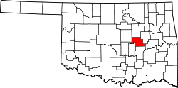
OKMap-doton-Bearden.PNG
Location of Bearden, Oklahoma
Coordinates: 35°21′25″N96°23′06″W / 35.35694°N 96.38500°W / 35.35694; -96.38500
Country United States
State Oklahoma
County Okfuskee
Area
[1]
  Total7.65 sq mi (19.82 km2)
  Land7.55 sq mi (19.54 km2)
  Water0.11 sq mi (0.28 km2)
Elevation
[2]
860 ft (260 m)
Population
 (2020)
  Total135
  Density17.89/sq mi (6.91/km2)
Time zone UTC-6 (Central (CST))
  Summer (DST) UTC-5 (CDT)
ZIP code
74859
Area codes 539/918
FIPS code 40-04700 [3]
GNIS feature ID2411672 [2]

Bearden is a town in Okfuskee County, Oklahoma, United States. The population was 135 at the 2020 Census. [4]

Contents

Geography

According to the United States Census Bureau, the town has a total area of 7.6 square miles (20 km2), all land.

Demographics

Historical population
CensusPop.Note
1990 142
2000 140−1.4%
2010 133−5.0%
2020 1351.5%
U.S. Decennial Census [5]

As of the census [3] of 2000, there were 140 people, 49 households, and 36 families residing in the town. The population density was 18.5 people per square mile (7.2/km2). There were 66 housing units at an average density of 8.7 per square mile (3.4/km2). The racial makeup of the town was 87.86% White, 7.86% African American, 2.14% Native American, 0.71% from other races, and 1.43% from two or more races. Hispanic or Latino of any race were 0.71% of the population.

There were 49 households, out of which 40.8% had children under the age of 18 living with them, 69.4% were married couples living together, 2.0% had a female householder with no husband present, and 24.5% were non-families. 18.4% of all households were made up of individuals, and 8.2% had someone living alone who was 65 years of age or older. The average household size was 2.86 and the average family size was 3.35.

In the town, the population was spread out, with 31.4% under the age of 18, 5.7% from 18 to 24, 30.0% from 25 to 44, 22.1% from 45 to 64, and 10.7% who were 65 years of age or older. The median age was 36 years. For every 100 females, there were 102.9 males. For every 100 females age 18 and over, there were 118.2 males.

The median income for a household in the town was $20,417, and the median income for a family was $21,875. Males had a median income of $21,429 versus $11,667 for females. The per capita income for the town was $11,359. There were 24.3% of families and 29.8% of the population living below the poverty line, including 46.7% of under eighteens and 13.6% of those over 64.

Related Research Articles

<span class="mw-page-title-main">Hendrix, Oklahoma</span> Town in Oklahoma, United States

Hendrix is a town in Bryan County, Oklahoma, United States. The population was 79 at both the 2010 and the 2000 censuses. According to the Bryan County Genealogy Society, Hendrix was originally known as Kemp City. This led to it often being confused with the neighboring town that is simply named Kemp. Hendrix was largely destroyed by a 1916 tornado.

<span class="mw-page-title-main">Dickson, Oklahoma</span> Town in Oklahoma, United States

Dickson is a town in Carter County, Oklahoma, United States. The population was 1,207 at the 2010 census. It is part of the Ardmore, Oklahoma Micropolitan Statistical Area.

<span class="mw-page-title-main">Depew, Oklahoma</span> Town in Oklahoma, United States

Depew is a town in Creek County, Oklahoma, United States. It is 41 miles southwest of Tulsa. The population was 411 at the 2020 census. The town was named in honor of New York Senator Chauncey Depew.

<span class="mw-page-title-main">Willow, Oklahoma</span> Town in Oklahoma, United States

Willow is a town in Greer County, Oklahoma, United States. The population was 119 as of the 2020 United States census. It is situated about 13 miles north of the county seat of Mangum, just west of the concurrent US Route 283 and Oklahoma State Highway 34.

<span class="mw-page-title-main">Olustee, Oklahoma</span> Town in Oklahoma, United States

Olustee is a town in Jackson County, Oklahoma, United States. "Olustee" is said to be a Seminole word meaning "pond" or from the Creek (Muscogee) language ue-lvste (/oy-lást-i/) meaning "black water", and being taken from the Battle of Olustee in Florida. The population was 468 as of the 2020 United States census.

<span class="mw-page-title-main">Carney, Oklahoma</span> Town in Oklahoma, United States

Carney is a town in Lincoln County, Oklahoma, United States. As of the 2020 census, the population of the town was 545.

<span class="mw-page-title-main">Davenport, Oklahoma</span> Town in Oklahoma, United States

Davenport is a town in Lincoln County, Oklahoma, United States. The population was 814 at the 2010 census.

<span class="mw-page-title-main">Fallis, Oklahoma</span> Town in Lincoln County, Oklahoma, United States

Fallis is a town in Lincoln County, Oklahoma, United States. The population was 27 at the 2010 census, a decline of 3.6 percent from the figure of 28 in 2000.

<span class="mw-page-title-main">Wellston, Oklahoma</span> Town in Oklahoma, United States

Wellston is a town in Lincoln County, Oklahoma, United States. The population was 788 at the 2010 census.

<span class="mw-page-title-main">Byars, Oklahoma</span> Town in Oklahoma, United States

Byars is a town in McClain County, Oklahoma, United States. The population was 184 at the 2020 census, down from 255 at the 2010 census.

<span class="mw-page-title-main">Rosedale, Oklahoma</span> Town in Oklahoma, United States

Rosedale is a town in McClain County, Oklahoma, United States. The population was 62 at the 2020 census, a 8.8% decrease from 2010.

<span class="mw-page-title-main">Lake Aluma, Oklahoma</span> Town in Oklahoma, United States

Lake Aluma is a town in Oklahoma County, Oklahoma, United States, and a part of the Oklahoma City Metropolitan Area. The population was 88 at the 2010 census.

<span class="mw-page-title-main">Luther, Oklahoma</span> Town in Oklahoma, United States

Luther is a town in Oklahoma County, Oklahoma, United States, and a part of the Oklahoma City Metropolitan Area. The population was 1,221 at the 2010 census. Sperling Best Places lists the population of 4073 for the 73054 Luther zip code, which includes the town and immediate surrounding area of rural residents.

<span class="mw-page-title-main">Hoffman, Oklahoma</span> Town in Oklahoma, United States

Hoffman is a town in Okmulgee County, Oklahoma, United States. The population was 81 at the 2020 census.

<span class="mw-page-title-main">Maramec, Oklahoma</span> Town in Oklahoma, United States

Maramec is a town in Pawnee County, Oklahoma, United States. The population was 91 at the 2010 census, a decline of 12.5 percent from the figure 104 recorded in 2000.

<span class="mw-page-title-main">Westport, Oklahoma</span> Town in Oklahoma, United States

Westport is a town in Pawnee County, Oklahoma, United States. The population was 298 at the 2010 census, a gain of 12.9 percent over the figure of 264 in 2000.

<span class="mw-page-title-main">Tribbey, Oklahoma</span> Town in Oklahoma, United States

Tribbey is a town in Pottawatomie County, Oklahoma, United States.The community was named for Alpheus M. Tribbey, landowner. The population was 337 by the 2020 United States census.

<span class="mw-page-title-main">Loveland, Oklahoma</span> Town in Oklahoma, United States

Loveland is a town in Tillman County, Oklahoma, United States. It is located about 38 miles southwest of Lawton, Oklahoma. The population was 13 at the 2020 Census. Loveland once had a post office that has since closed. The post office was popular around Valentine's Day, when people often drove many miles to have their valentines postmarked "Loveland".

<span class="mw-page-title-main">Burns Flat, Oklahoma</span> Town in Oklahoma, United States

Burns Flat is a town in Washita County, Oklahoma, United States. The population was 2,057 at the 2010 census.

<span class="mw-page-title-main">Oklahoma, Pennsylvania</span> Borough in Pennsylvania, United States

Oklahoma is a borough in Westmoreland County, Pennsylvania, United States. The population was 809 at the time of the 2010 census.

References

  1. "ArcGIS REST Services Directory". United States Census Bureau. Retrieved September 20, 2022.
  2. 1 2 U.S. Geological Survey Geographic Names Information System: Bearden, Oklahoma
  3. 1 2 "U.S. Census website". United States Census Bureau . Retrieved January 31, 2008.
  4. "Bearden (town), Oklahoma". US Census Bureau. Retrieved October 13, 2023.
  5. "Census of Population and Housing". Census.gov. Retrieved June 4, 2015.