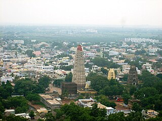
Mangalagiri is a model town in Guntur district of Andhra Pradesh. It is a major suburb of Vijayawada and also part of Vijayawada metropolitan area. It is currently the 31st most populous city of Andhra Pradesh. The town is the headquarters of Mangalagiri mandal under Guntur revenue division. It is situated on National Highway 16 between Vijayawada and Guntur. The town was known to have existed since 225 B.C.

Krishna district is one of the twenty-six districts in the Indian state of Andhra Pradesh, with Machilipatnam as its administrative headquarters. It is the coastal district of Andhra Pradesh. Machilipatnam is the most populated city in the district. It is surrounded on the east by Bay of Bengal, west by Guntur and north by Eluru and NTR districts and south by Bay of Bengal. In 2022 Krishna district was divided into Krishna and NTR districts.

Vijayawada is the second largest city in the Indian state of Andhra Pradesh and is a part of the state's Capital Region. It is the administrative headquarters of the NTR district. It comprises NTR and part of Krishna district. Vijayawada lies on the banks of Krishna river surrounded by the hills of Eastern Ghats, known as Indrakeeladri Hills. It geographically lies on the center spot of Andhra Pradesh. The city has been described as the commercial, political, cultural and educational capital of Andhra Pradesh, second largest city in Andhra Pradesh and is one of the fastest growing urban areas in India.

Machilipatnam, also known as Bandaru, is a city in Krishna district of the Indian state of Andhra Pradesh. It is a municipal corporation and the administrative headquarters of Krishna district. It is also the mandal headquarters of Machilipatnam mandal in Machilipatnam revenue division of the district. The ancient port town served as the settlement of European traders from the 16th century, and it was a major trading port for the Portuguese, British, Dutch and French in the 17th century.

Dharmavaram is a city in Sri Sathya Sai District of the Indian state of Andhra Pradesh. It is the mandal and divisional headquarters of Dharmavaram mandal and Dharmavaram revenue division respectively. The city is known for its handloom silk sarees. The city is renowned for cotton, silk weaving industries and leather puppets. The city is called as Silk city of Andhra Pradesh.
Gudivada is a city in Krishna district of the Indian state of Andhra Pradesh. It is a municipality and the headquarters of Gudivada mandal in Gudivada revenue division. It is one of the cities in the state to be a part of Andhra Pradesh Capital Region. It is the twenty-seventh most populous city in Andhra Pradesh and the three-hundredth most populous city in India with a population of 118,167 according to the 2011 Census of India.

Nuzvid is a city in Eluru district of the Indian state of Andhra Pradesh. It serves as the administrative headquarters for Nuzvid mandal and Nuzvid revenue division.
Gudur is a town in Tirupati district of the Indian state of Andhra Pradesh. It is a municipality and the headquarters of Gudur mandal and Gudur revenue division.
Kanuru is a Residential area of Vijayawada in Krishna district of the Indian state of Andhra Pradesh. It is an education hub of Vijayawada. It is located in Penamaluru mandal of Vijayawada revenue division. As per the G.O. No. M.S.104 (dated:23-03-2017), Municipal Administration and Urban Development Department, it became a part of Vijayawada metropolitan area.
Pedana is a municipality and the headquarters of Pedana mandal under Machilipatnam revenue division of Krishna district of the Indian state of Andhra Pradesh. It is located at a distance of 8 km (5.0 mi) from the district headquarters, Machilipatnam.

Kondapalli is a suburb of Vijayawada city which on the Nort-East part of the city in NTR district of the Indian state of Andhra Pradesh kondapalli toys are also very famous in the state.
Vuyyuru is a town in Krishna district of the Indian state of Andhra Pradesh. It is a Nagar panchayat and the headquarters of Vuyyuru Mandal. It is emerging as neighbourhood of Vijayawada, India situated 30 km away.
Kankipadu is a part of Vijayawada and a town in Krishna district of the Indian state of Andhra Pradesh. It is also the mandal headquarters of Kankipadu mandal in Vuyyuru revenue division.

Narasannapeta is a census town in Srikakulam district of the Indian state of Andhra Pradesh. It is the mandal headquarters of Narasannapeta mandal in Srikakulam revenue division. 43 villages are there under the administrative division of Narasannapeta.

Ramavarappadu is a residential hub located in the East-Central part of Vijayawada in Krishna district of the Indian state of Andhra Pradesh. It is located in Vijayawada (rural) mandal of Vijayawada revenue division. As per the G.O. No. M.S.104 (dated:23-03-2017), Municipal Administration and Urban Development Department, it became a part of Vijayawada metropolitan area.

Guntupalli is a suburb of Vijayawada located in the NTR district of the Indian state of Andhra Pradesh. It is located in Ibrahimpatnam mandal of Vijayawada revenue division.
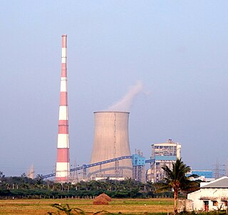
Dr Narla Tata Rao Thermal Power Plant or Vijayawada Thermal Power Plant is located at Vijayawada in Andhra Pradesh. It is named after, Narla Tata Rao, the erstwhile chairman of the Andhra Pradesh State Electricity board. The power plant is one of the coal-based power plants of APGENCO. It is well placed between Ibrahimpatnam and Kondapalli villages.

Ibrahimpatnam mandal is one of the 20 mandals that constitute the NTR district of the State of Andhra Pradesh in India. It is under the administration of the Vijayawada revenue division and the mandal headquarters are located at Ibrahimpatnam town. The mandal is located on the banks of Krishna River and is bounded by Kanchikacherla, Veerullapadu, G. Konduru and Vijayawada (rural) mandals. The mandal is also a part of the Andhra Pradesh Capital Region under the jurisdiction of APCRDA.
Vaddeswaram is a census town in Guntur district of the Indian state of Andhra Pradesh. It is located at a distance of 5 km (3.1 mi) from Krishna River, in Tadepalle mandal part of Mangalagiri Tadepalle Municipal Corporation part of Guntur revenue division.

NTR district is a district in the Indian state of Andhra Pradesh. The administrative headquarters is located at Vijayawada. The district is named after former Chief Minister of Andhra Pradesh N. T. Rama Rao.

