Ickesburg, Pennsylvania

Last updated

Ickesburg
USA Pennsylvania location map.svg
Red pog.svg
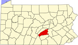
Ickesburg
Location of Ickesburg in Pennsylvania
Coordinates: 40°27′21.6″N77°21′7.2″W / 40.456000°N 77.352000°W / 40.456000; -77.352000
Country United States
State Pennsylvania
County Perry
Township Saville
Area
  Total0.412 sq mi (1.07 km2)
  Land0.409 sq mi (1.06 km2)
  Water0.003 sq mi (0.008 km2)
Elevation
637 ft (194 m)
GNIS feature ID2830809

Ickesburg is a census-designated place in Saville Township, Perry County, Pennsylvania, United States at the junction of Routes 17 and 74. [1] It is located on the Panther Creek, which flows into the Buffalo Creek, a tributary of the Juniata River. Its ZIP code is 17037 and it is served by area codes 717 and 223.

Related Research Articles

<span class="mw-page-title-main">Snyder County, Pennsylvania</span> County in Pennsylvania, United States

Snyder County is a county in the Commonwealth of Pennsylvania. As of the 2020 census, the population was 39,736. The county seat is Middleburg. Snyder County was formed in 1855 from parts of Union County.

<span class="mw-page-title-main">Perry County, Pennsylvania</span> County in Pennsylvania, United States

Perry County is a county in the Commonwealth of Pennsylvania. As of the 2020 census, the population was 45,842. The county seat is New Bloomfield. The county was created on March 22, 1820, and was named for Oliver Hazard Perry, a hero of the War of 1812, who had recently died. It was originally part of Cumberland County and was created in part because residents did not want to travel over the mountain to Carlisle, the county seat of Cumberland County. Landisburg became the temporary county seat before New Bloomfield was ultimately chosen.

<span class="mw-page-title-main">Crete, Illinois</span> Village in Illinois, United States

Crete is a village in Will County, Illinois, United States. It is a far south suburb of Chicago, 30 miles from the Loop and only 6 miles from the Indiana border. The population was 8,465 at the 2020 census. Originally named Wood's Corner, it was founded in 1836 by Vermonters Dyantha and Willard Wood.

<span class="mw-page-title-main">Lake Meade, Pennsylvania</span> Census-designated place in Pennsylvania, United States

Lake Meade is an unincorporated census-designated place in Latimore and Reading townships, Adams County, Pennsylvania, United States. The population was 2,539 at the 2020 census.

<span class="mw-page-title-main">Sewickley Hills, Pennsylvania</span> Borough in Pennsylvania, United States

Sewickley Hills is a borough in Allegheny County, Pennsylvania, United States. The population was 689 at the 2020 census. It is a residential suburb of the Pittsburgh metropolitan area.

<span class="mw-page-title-main">Wilmerding, Pennsylvania</span> Borough in Pennsylvania, United States

Wilmerding is a borough in Allegheny County, Pennsylvania, United States. The population was 1,781 at the 2020 census. It is located 12 miles (19 km) southeast of Pittsburgh. At the start of the twentieth century, it had extensive foundries and machine shops of the Westinghouse Air Brake Company. Wilmerding is adjacent to the borough of Turtle Creek, which takes its name from a small stream that flows past both places.

<span class="mw-page-title-main">Robesonia, Pennsylvania</span> Borough in Pennsylvania, United States

Robesonia is a borough that is located in Berks County, Pennsylvania, United States. The population was 2,061 at the time of the 2010 census.

Schlusser is a census-designated place (CDP) in North Middleton and Middlesex townships, Cumberland County, Pennsylvania, United States. The population was 5,265 at the 2010 census. It is part of the Harrisburg–Carlisle Metropolitan Statistical Area.

<span class="mw-page-title-main">Shippensburg Township, Pennsylvania</span> Township in Pennsylvania, United States

Shippensburg Township is a township in Cumberland County, Pennsylvania, United States, adjacent to the borough of Shippensburg. The population of the township was 5,429 at the 2010 census, up from 4,504 at the 2000 census. The township is the location of Shippensburg University of Pennsylvania.

<span class="mw-page-title-main">Franklin Township, Huntingdon County, Pennsylvania</span> Township in Pennsylvania, United States

Franklin Township is a township in Huntingdon County, Pennsylvania, United States. The population was 499 at the 2020 census.

<span class="mw-page-title-main">Orbisonia, Pennsylvania</span> Borough in Pennsylvania, United States

Orbisonia is a borough in Huntingdon County, Pennsylvania, United States. The population was 428 at the 2010 census.

Lebanon South is an unincorporated area and census-designated place (CDP) in Lebanon County, Pennsylvania, United States. The population was 2,270 at the 2010 census.

Pleasant Hill is an unincorporated community and census-designated place (CDP) in Lebanon County, Pennsylvania, United States. The population was 2,643 at the 2010 census, up from 2,301 at the 2000 census.

<span class="mw-page-title-main">Reedsville, Pennsylvania</span> Census-designated place in Pennsylvania, United States

Reedsville is a census-designated place (CDP) in the Kishacoquillas Valley of Mifflin County, Pennsylvania, United States. The population was 641 at the 2010 census. Reedsville has a high Amish population.

<span class="mw-page-title-main">Kulpsville, Pennsylvania</span> Census-designated place in Pennsylvania, United States

Kulpsville is a census-designated place (CDP) in Montgomery County, Pennsylvania. The population was 8,194 at the 2010 census. It is located in Towamencin Township, which is part of the North Penn Valley region that is centered around the borough of Lansdale. The name is derived from the Kulp family.

<span class="mw-page-title-main">Saville Township, Pennsylvania</span> Township in Pennsylvania, United States

Saville Township is a second-class township in a mountainous part of Perry County, Pennsylvania, United States. As of the 2020 census, the township had a total population of 2,597. It was founded in 1817, dividing from Tyrone Township while the area was still part of Cumberland County. It is served by two major roads, PA 74, locally called Veterans Way, and PA 17, called the Tuscorara Path. The county office is at 3954 Veterans Way, in Elliottsburg, in the far southern part of the township. The area is overwhelmingly agricultural, with small population centers in Ickesburg and the hamlet of Saville.

<span class="mw-page-title-main">Berwyn, Pennsylvania</span> Census-designated place in Pennsylvania, United States

Berwyn is a census-designated place (CDP) in Chester County, Pennsylvania, United States. Berwyn is located within Tredyffrin and Easttown Townships. The area is part of the Philadelphia Main Line suburbs.

<span class="mw-page-title-main">Idaville, Pennsylvania</span> Census-designated place in Pennsylvania, United States

Idaville is a census-designated place that is located in Huntington Township, Adams County, Pennsylvania, United States. As of the 2020 census, its population was 176. Idaville is served by the Bermudian Springs School District.

<span class="mw-page-title-main">Spinnerstown, Pennsylvania</span> Census-designated place in Pennsylvania, United States

Spinnerstown is a census-designated place in Milford Township, Bucks County, Pennsylvania, United States. It is located just northwest of the Quakertown interchange of I-476 with Route 663. As of the 2010 census, the population was 1,826 residents.

Wertzville is an unincorporated community in Silver Spring Township, Cumberland County, Pennsylvania, United States, along the southern foothill of Blue Mountain. The Simmons Creek flows south through the village to the Conodoguinet Creek, which flows generally east to the Susquehanna River. It is located on the northwestern terminus of Route 114 with Route 944 and is served by the Cumberland Valley School District. The community is served by the Mechanicsburg post office, with the ZIP code of 17050.

References

  1. "2023 U.S. Gazetteer Files". United States Census Bureau. 2023. Retrieved October 15, 2023.

40°27′21″N77°21′06″W / 40.45583°N 77.35167°W / 40.45583; -77.35167