Turbett Township, Pennsylvania | |
---|---|
![]() | |
Map of Juniata County, Pennsylvania highlighting Turbett Township | |
![]() Map of Juniata County, Pennsylvania | |
Country | United States |
State | Pennsylvania |
County | Juniata |
Settled | 1755 |
Incorporated | 1815 |
Area | |
• Total | 16.52 sq mi (42.79 km2) |
• Land | 16.37 sq mi (42.41 km2) |
• Water | 0.15 sq mi (0.38 km2) |
Population | |
• Total | 977 ![]() |
• Estimate (2022) [2] | 967 |
• Density | 61.19/sq mi (23.63/km2) |
Time zone | UTC-5 (EST) |
• Summer (DST) | UTC-4 (EDT) |
Area code | 717 |
FIPS code | 42-067-77824 |
Turbett Township is a township in Juniata County, Pennsylvania, United States. The population was 977 at the 2020 census, [2] a decline from the figure of 981 tabulated in 2010. [3]
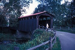
The Lehman's, Port Royal Covered Bridge was listed on the National Register of Historic Places in 1979. [4]
According to the United States Census Bureau, the township has a total area of 16.5 square miles (42.8 km2), of which 16.4 square miles (42.4 km2) are land and 0.2 square miles (0.4 km2), or 0.89%, are water. [3] The Juniata River forms the northeastern border of the township.
Turbett Township is in south-central Juniata County and is bordered by Milford Township and the borough of Port Royal to the north, Walker Township to the north and east, Perry County to the south and Spruce Hill Township to the west. The southern boundary of the township follows the top of Tuscarora Mountain, part of the Ridge-and-Valley Appalachians.
The township includes the unincorporated communities of Old Port and Tuscarora.
Census | Pop. | Note | %± |
---|---|---|---|
1850 | 1,399 | — | |
1860 | 703 | −49.7% | |
1870 | 714 | 1.6% | |
1880 | 747 | 4.6% | |
1890 | 693 | −7.2% | |
1900 | 683 | −1.4% | |
1910 | 648 | −5.1% | |
1920 | 569 | −12.2% | |
1930 | 520 | −8.6% | |
1940 | 536 | 3.1% | |
1950 | 576 | 7.5% | |
1960 | 578 | 0.3% | |
1970 | 678 | 17.3% | |
1980 | 793 | 17.0% | |
1990 | 779 | −1.8% | |
2000 | 819 | 5.1% | |
2010 | 981 | 19.8% | |
2020 | 977 | −0.4% | |
2022 (est.) | 967 | [2] | −1.0% |
U.S. Decennial Census [5] |
As of the census [6] of 2000, there were 819 people, 308 households, and 251 families residing in the township. The population density was 49.9 people per square mile (19.3/km2). There were 403 housing units at an average density of 24.5/sq mi (9.5/km2). The racial makeup of the township was 99.39% White, 0.12% African American, 0.24% from other races, and 0.24% from two or more races. Hispanic or Latino of any race were 0.73% of the population.
There were 308 households, out of which 33.8% had children under the age of 18 living with them, 72.1% were married couples living together, 6.2% had a female householder with no husband present, and 18.5% were non-families. 17.2% of all households were made up of individuals, and 9.4% had someone living alone who was 65 years of age or older. The average household size was 2.66 and the average family size was 2.99.
In the township the population was spread out, with 25.2% under the age of 18, 8.4% from 18 to 24, 28.1% from 25 to 44, 26.0% from 45 to 64, and 12.3% who were 65 years of age or older. The median age was 38 years. For every 100 females there were 101.2 males. For every 100 females age 18 and over, there were 100.3 males.
The median income for a household in the township was $35,000, and the median income for a family was $40,492. Males had a median income of $28,095 versus $21,538 for females. The per capita income for the township was $14,905. About 6.1% of families and 8.8% of the population were below the poverty line, including 10.0% of those under age 18 and 27.5% of those age 65 or over.
Tuscarora township is a township in Steuben County, New York, United States. The population was 1,388 at the 2020 census. The township is named after the Tuscarora tribe.
Frankstown Township is a township in Blair County, Pennsylvania, United States. It is part of the Altoona Metropolitan Statistical Area. The population was 7,399 at the 2020 census. The township was named after Stephen Franks, a pioneer citizen.
Penn Township is a township in Cumberland County, Pennsylvania, United States, established on October 23, 1860, from Upper Dickinson Township. The population was 2,924 at the 2010 census.
Fannett Township is a township in Franklin County, Pennsylvania, United States. The population was 2,483 at the 2020 census. The township derives its name as an older variant spelling of Fanad, County Donegal, from early Irish settlement in the area. It was formed before 1762, and until about 1795 included the area now in Metal Township.
Beale Township is a township in Juniata County, Pennsylvania, United States. The population was 769 at the 2020 census, a decline from the figure of 830 tabulated in 2010.
Delaware Township is a township in Juniata County, Pennsylvania, United States. The population was 1,610 at the 2020 census.
East Waterford is a census-designated place (CDP) in Tuscarora and Lack townships in Juniata County, Pennsylvania, United States. The population was 196 at the 2010 census.
Lack Township is a township that is located in Juniata County, Pennsylvania, United States. The population was 637 at the time of the 2020 census.
Mifflintown is a borough in and the county seat of Juniata County, Pennsylvania, United States. The population was 842 at the 2020 census.
Milford Township is a township in Juniata County, Pennsylvania, United States. The population was 1,989 at the 2020 census, a decline from the figure of 2,088 tabulated in 2010.
Port Royal is a borough in Juniata County, Pennsylvania, United States. The population was 815 at the 2020 census.
Spruce Hill Township is a township in Juniata County, Pennsylvania, United States. The population was 786 at the 2020 census, a decline from the figure of 834 tabulated in 2010.
Tuscarora Township is a township that is located in southwestern Juniata County, Pennsylvania, United States. The population was 1,131 at the time of the 2020 census.
Walker Township is a township in Juniata County, Pennsylvania, United States. The population was 2,797 at the 2020 census.
Buffalo Township is a township in Perry County, Pennsylvania, United States. The population was 1,222 at the 2020 census.
Greenwood Township is a township in Perry County, Pennsylvania, United States. The population was 1,032 at the 2020 census.
Juniata Township is a township in Perry County, Pennsylvania, United States. As of the 2020 census, the township population was 1,531.
Tuscarora Township is a township in Perry County, Pennsylvania, United States. The population was 1,308 at the 2020 census.
Tyrone Township is a township in Perry County, Pennsylvania, United States. The population was 1,905 at the 2020 census. The principal communities in the township are the villages of Green Park and Loysville. The township surrounds the borough of Landisburg.
The Juniata County School District is a rural, public school district located in Juniata County, Pennsylvania. The district is one of the 500 public school districts of Pennsylvania and one of seven county-wide school districts in the Commonwealth. The district encompasses approximately 372 square miles (960 km2). Juniata County School District serves residents in: Beale Township, Delaware Township, Fayette Township, Fermanagh Township, Lack Township, Milford Township, Monroe Township, Spruce Hill Township, Susquehanna Township, Turbett Township, Tuscarora Township and Walker Township. It also serves the residents of the following boroughs: Mifflin, Mifflintown, Port Royal, Thompsontown, East Salem, East Waterford, Mexico, McAlisterville and Richfield. According to 2000 federal census data, Juniata County School District served a resident population of 22,273 people. By 2013, the US Census reports that the Juniata County School District's resident population grew to 24,005 people. The educational attainment levels for the Juniata County School District population were 82.4% high school graduates and 11.2% college graduates. The district is one of the 500 public school districts of Pennsylvania.