Fayette Township, Pennsylvania

Last updated

Fayette Township,
Pennsylvania
McAlisterville Post Office.jpg
The post office in McAlisterville
Map of Juniata County, Pennsylvania Highlighting Fayette Township.PNG
Map of Juniata County, Pennsylvania highlighting Fayette Township
Map of Pennsylvania highlighting Juniata County.svg
Map of Juniata County, Pennsylvania
Country United States
State Pennsylvania
County Juniata
Settled1755
Incorporated1834
Area
[1]
  Total40.04 sq mi (103.70 km2)
  Land40.04 sq mi (103.70 km2)
  Water0.00 sq mi (0.00 km2)
Elevation
650 ft (200 m)
Population
 (2020) [2]
  Total3,339 Decrease2.svg
  Estimate 
(2022) [2]
3,311
  Density88.17/sq mi (34.04/km2)
Time zone UTC-5 (EST)
  Summer (DST) UTC-4 (EDT)
ZIP Codes
Area code 717
FIPS code 42-067-25440

Fayette Township is a township in Juniata County, Pennsylvania, United States. The population was 3,339 at the 2020 census. [2]

Contents

Geography

According to the United States Census Bureau, the township has a total area of 40.0 square miles (103.7 km2), all land. It is bordered by Mifflin and Snyder Counties to the north, Monroe Township to the east, Delaware and Walker Townships to the south and Fermanagh Township to the west. The primary unincorporated community in the township is McAlisterville, located near the center of the township. Other communities in the township are Oakland Mills in the west, and Swales, Bunkertown, and Cocolamus in the east.

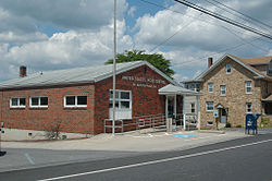
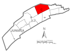
The northern boundary of the township follows the crest of Shade Mountain. Pennsylvania Route 35 passes through the center of the township from southwest to northeast, and Pennsylvania Route 235 crosses it in McAlisterville.

Demographics

Historical population
CensusPop.Note
1850 1,550
1860 2,00629.4%
1870 2,0512.2%
1880 2,028−1.1%
1890 1,755−13.5%
1900 1,634−6.9%
1910 1,466−10.3%
1920 1,446−1.4%
1930 1,5013.8%
1940 1,73315.5%
1950 1,730−0.2%
1960 1,91710.8%
1970 2,16512.9%
1980 2,67923.7%
1990 3,00212.1%
2000 3,2528.3%
2010 3,4786.9%
2020 3,339−4.0%
2022 (est.)3,311 [2] −0.8%
U.S. Decennial Census [3]

As of the census [4] of 2000, there were 3,252 people, 1,219 households, and 936 families residing in the township. The population density was 81.8 inhabitants per square mile (31.6/km2). There were 1,372 housing units at an average density of 34.5 per square mile (13.3/km2). The racial makeup of the township was 98.77% White, 0.34% African American, 0.06% Native American, 0.12% Asian, 0.15% Pacific Islander, 0.28% from other races, and 0.28% from two or more races. Hispanic or Latino of any race were 0.71% of the population.

There were 1,219 households, out of which 33.9% had children under the age of 18 living with them, 67.4% were married couples living together, 5.8% had a female householder with no husband present, and 23.2% were non-families. 20.5% of all households were made up of individuals, and 10.2% had someone living alone who was 65 years of age or older. The average household size was 2.67 and the average family size was 3.08.

In the township the population was spread out, with 27.3% under the age of 18, 8.0% from 18 to 24, 27.7% from 25 to 44, 23.0% from 45 to 64, and 14.0% who were 65 years of age or older. The median age was 36 years. For every 100 females, there were 100.2 males. For every 100 females age 18 and over, there were 96.4 males.

The median income for a household in the township was $30,653, and the median income for a family was $35,884. Males had a median income of $29,679 versus $21,362 for females. The per capita income for the township was $16,548. About 7.0% of families and 9.5% of the population were below the poverty line, including 11.7% of those under age 18 and 5.2% of those age 65 or over.

Cocolamus Mennonite Church in Bunkertown Cocolamus Mennonite Church Bunkertown PA.jpg
Cocolamus Mennonite Church in Bunkertown

Related Research Articles

<span class="mw-page-title-main">Richland Township, Allegheny County, Pennsylvania</span> Township in Pennsylvania, United States

Richland Township is a township in Allegheny County, Pennsylvania, United States. The population was 11,942 at the 2020 census.

<span class="mw-page-title-main">South Bend Township, Pennsylvania</span> Township in Pennsylvania, United States

South Bend Township is a township in Armstrong County, Pennsylvania, United States. The population was 1,010 at the 2020 census, a decrease from the figure of 1,167 tabulated in 2010.

<span class="mw-page-title-main">Canton Township, Bradford County, Pennsylvania</span> Township in Pennsylvania, United States

Canton Township is a township in Bradford County, Pennsylvania, United States. It is part of Northeastern Pennsylvania. The population was 2,143 at the 2010 census.

<span class="mw-page-title-main">Brady Township, Huntingdon County, Pennsylvania</span> Township in Pennsylvania, United States

Brady Township is a township in Huntingdon County, Pennsylvania, United States. The population was 1,172 at the 2010 census. The township includes the villages of Fousetown and Airydale. Brady Township was named for Hugh Brady, a brigadier general in the United States Army who was born in Huntingdon, Pennsylvania. Township had been separated from Henderson in 1846.

<span class="mw-page-title-main">Union Township, Huntingdon County, Pennsylvania</span> Township in Pennsylvania, United States

Union Township is a township in Huntingdon County, Pennsylvania, United States. The population was 951 at the 2020 census.

<span class="mw-page-title-main">West Township, Huntingdon County, Pennsylvania</span> Township in Pennsylvania, United States

West Township is a township that is located in Huntingdon County, Pennsylvania, United States. The population was 517 at the time of the 2020 census.

<span class="mw-page-title-main">Armstrong Township, Indiana County, Pennsylvania</span> Township in Pennsylvania, United States

Armstrong Township is a township in Indiana County, Pennsylvania, United States. The township was named after General Armstrong, who commanded the celebration against Kittanning. The population was 2,786 at the 2020 census. The township includes the communities of Crete, Miller, Parkwood, Tannery Village, and Thomas. It surrounds the separately incorporated borough of Shelocta.

<span class="mw-page-title-main">Fermanagh Township, Juniata County, Pennsylvania</span> Township in Pennsylvania, United States

Fermanagh Township is a township in Juniata County, Pennsylvania, United States. The population was 2,865 at the 2020 census, an increase over the figure of 2,811 tabulated in 2010.

<span class="mw-page-title-main">Greenwood Township, Juniata County, Pennsylvania</span> Township in Pennsylvania, United States

Greenwood Township is a township in Juniata County, Pennsylvania, United States. The population was 533 at the 2020 census, an increase over the figure of 617 tabulated in 2010.

<span class="mw-page-title-main">McAlisterville, Pennsylvania</span> Census-designated place in Pennsylvania, United States

McAlisterville is an unincorporated community and census-designated place (CDP) in Fayette Township, Juniata County, Pennsylvania, United States. The population was 971 at the 2010 census.

<span class="mw-page-title-main">Susquehanna Township, Juniata County, Pennsylvania</span> Township in Pennsylvania, United States

Susquehanna Township is a township in Juniata County, Pennsylvania, United States. The population was 1,205 at the 2020 census.

<span class="mw-page-title-main">Manheim Township, Lancaster County, Pennsylvania</span> Township in Pennsylvania, United States

Manheim Township is a township in Lancaster County, Pennsylvania, United States. It was established in 1729. The township's southernmost border meets the city limits of Lancaster and includes the communities of Neffsville, Dillerville, and Landis Valley. Its population, as of the 2020 census, was 43,977 making it the second largest municipality in the county after Lancaster City.

<span class="mw-page-title-main">Heidelberg Township, Lebanon County, Pennsylvania</span> Township in Pennsylvania, United States

Heidelberg Township is a township in Lebanon County, Pennsylvania, United States. The population was 4,080 at the 2020 census. It is part of the Lebanon, Pennsylvania Metropolitan Statistical Area.

<span class="mw-page-title-main">Salem Township, Mercer County, Pennsylvania</span> Township in Pennsylvania, United States

Salem Township is a township in Mercer County, Pennsylvania, United States. The population was 752 at the 2020 census, down from 754 in 2010.

<span class="mw-page-title-main">Miller Township, Perry County, Pennsylvania</span> Township in Pennsylvania, United States

Miller Township is a township in Perry County, Pennsylvania, United States. The population was 963 at the 2020 census.

<span class="mw-page-title-main">Hegins Township, Pennsylvania</span> Township in Pennsylvania, United States

Hegins Township is a township in Schuylkill County, Pennsylvania, United States. The population was 3,350 at the 2020 census.

<span class="mw-page-title-main">Hubley Township, Pennsylvania</span> Township in Pennsylvania, United States

Hubley Township is a township in Schuylkill County, Pennsylvania, United States. The population was 865 at the 2010 census, an increase of a little more than 1% from the previous census in 2010.

<span class="mw-page-title-main">Upper Turkeyfoot Township, Pennsylvania</span> Township in Pennsylvania, United States

Upper Turkeyfoot Township is a township in Somerset County, Pennsylvania, United States. The population was 1,063 at the 2020 census. It is part of the Johnstown, Pennsylvania metropolitan statistical area.

<span class="mw-page-title-main">Duncan Township, Tioga County, Pennsylvania</span> Township in Pennsylvania, United States

Duncan Township is a township in Tioga County, Pennsylvania, United States. The population was 188 at the 2020 census.

<span class="mw-page-title-main">Middlebury Township, Pennsylvania</span> Township in Pennsylvania, United States

Middlebury Township is a township in Tioga County, Pennsylvania, United States. The population was 1,308 at the 2020 census.

References

  1. "2016 U.S. Gazetteer Files". United States Census Bureau. Retrieved August 14, 2017.
  2. 1 2 3 4 Bureau, US Census. "City and Town Population Totals: 2020-2022". Census.gov. US Census Bureau. Retrieved January 31, 2024.
  3. "Census of Population and Housing". Census.gov. Retrieved June 4, 2016.
  4. "U.S. Census website". United States Census Bureau . Retrieved January 31, 2008.

40°37′00″N77°16′59″W / 40.61667°N 77.28306°W / 40.61667; -77.28306