Greenwood Township, Juniata County, Pennsylvania

Last updated
Greenwood Township,
Juniata County,
Pennsylvania
DIMMSVILLE COVERED BRIDGE.jpg
Map of Juniata County, Pennsylvania Highlighting Greenwood Township.PNG
Map of Juniata County, Pennsylvania highlighting Greenwood Township
Map of Pennsylvania highlighting Juniata County.svg
Map of Juniata County, Pennsylvania

Greenwood School District Map.png

Greenwood Township is one of six municipalities encompassed by the Greenwood School District.
Country United States
State Pennsylvania
County Juniata
Settled1763
Incorporated1767
Area
[1]
  Total19.46 sq mi (50.40 km2)
  Land19.46 sq mi (50.40 km2)
  Water0.00 sq mi (0.00 km2)
Population
 (2020) [2]
  Total533 Decrease2.svg
  Estimate 
(2022) [2]
539
  Density32.22/sq mi (12.44/km2)
Time zone UTC-5 (EST)
  Summer (DST) UTC-4 (EDT)
Zip code
17062
Area code 717
FIPS code 42-067-31424

Greenwood Township is a township in Juniata County, Pennsylvania, United States. The population was 533 at the 2020 census, [2] an increase over the figure of 617 tabulated in 2010. [3]

Contents

History

The Dimmsville Covered Bridge was listed on the National Register of Historic Places in 1979. [4] It collapsed in 2017.

Geography

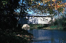
Greenwood Township is in eastern Juniata County and is centered on Turkey Valley, with Shellys Ridge and Lock Ridge to the south. Cocolamus Creek, a tributary of the Juniata River, flows through the western part of the township. According to the United States Census Bureau, the township has a total area of 19.5 square miles (50.4 km2), of which 0.9 acres (3,723 m2), or 0.01%, are water. [3]

Greenwood Township is bordered by Monroe Township to the north, Susquehanna Township to the east, Greenwood Township, Perry County to the south, and Delaware Township to the west. Unincorporated communities in the township include Seven Stars and Dimmsville.

Pennsylvania Route 235 passes through the township, leading east to Liverpool on the Susquehanna River, and west to East Salem.

Demographics

Historical population
CensusPop.Note
1850 1,651
1860 635−61.5%
1870 74417.2%
1880 601−19.2%
1890 569−5.3%
1900 563−1.1%
1910 447−20.6%
1920 433−3.1%
1930 349−19.4%
1940 3572.3%
1950 286−19.9%
1960 35323.4%
1970 3879.6%
1980 48625.6%
1990 4931.4%
2000 54811.2%
2010 61712.6%
2020 533−13.6%
2022 (est.)539 [2] 1.1%
U.S. Decennial Census [5]

As of the census [6] of 2000, there were 548 people, 194 households, and 152 families residing in the township. The population density was 27.9 inhabitants per square mile (10.8/km2). There were 223 housing units at an average density of 11.3/sq mi (4.4/km2). The racial makeup of the township was 98.54% White, 0.73% African American, 0.18% Asian, and 0.55% from two or more races. Hispanic or Latino of any race were 0.73% of the population.

There were 194 households, out of which 33.0% had children under the age of 18 living with them, 74.7% were married couples living together, 2.1% had a female householder with no husband present, and 21.6% were non-families. 16.5% of all households were made up of individuals, and 7.7% had someone living alone who was 65 years of age or older. The average household size was 2.82 and the average family size was 3.24.

In the township the population was spread out, with 27.0% under the age of 18, 6.9% from 18 to 24, 27.6% from 25 to 44, 25.7% from 45 to 64, and 12.8% who were 65 years of age or older. The median age was 38 years. For every 100 females there were 105.2 males. For every 100 females age 18 and over, there were 99.0 males.

The median income for a household in the township was $40,139, and the median income for a family was $40,417. Males had a median income of $32,054 versus $20,875 for females. The per capita income for the township was $17,344. About 5.0% of families and 7.0% of the population were below the poverty line, including 5.4% of those under age 18 and 5.5% of those age 65 or over.

Related Research Articles

<span class="mw-page-title-main">Latimore Township, Pennsylvania</span> Township in Pennsylvania, United States

Latimore Township is a township in Adams County, Pennsylvania, United States. The population was 2,580 at the 2010 census.

<span class="mw-page-title-main">Leroy Township, Bradford County, Pennsylvania</span> Township in Pennsylvania, United States

LeRoy Township is a township in Bradford County, Pennsylvania, United States. It is part of Northeastern Pennsylvania. The population was 718 at the 2010 census.

<span class="mw-page-title-main">Middlesex Township, Cumberland County, Pennsylvania</span> Township in Pennsylvania, United States

Middlesex Township is a township located in Cumberland County, Pennsylvania, United States. As of the 2010 census, the township had a total population of 7,040.

<span class="mw-page-title-main">Reed Township, Pennsylvania</span> Township in Pennsylvania, United States

Reed Township is a township in Dauphin County, Pennsylvania, United States. The population was 229 at the 2020 census, a decline from 239 in 2010.

<span class="mw-page-title-main">Fannett Township, Pennsylvania</span> Township in Pennsylvania, United States

Fannett Township is a township in Franklin County, Pennsylvania, United States. The population was 2,483 at the 2020 census. The township derives its name as an older variant spelling of Fanad, County Donegal, from early Irish settlement in the area. It was formed before 1762, and until about 1795 included the area now in Metal Township.

<span class="mw-page-title-main">Beale Township, Pennsylvania</span> Township in Pennsylvania, United States

Beale Township is a township in Juniata County, Pennsylvania, United States. The population was 769 at the 2020 census, a decline from the figure of 830 tabulated in 2010.

<span class="mw-page-title-main">Delaware Township, Juniata County, Pennsylvania</span> Township in Pennsylvania, United States

Delaware Township is a township in Juniata County, Pennsylvania, United States. The population was 1,610 at the 2020 census.

<span class="mw-page-title-main">Fayette Township, Pennsylvania</span> Township in Pennsylvania, United States

Fayette Township is a township in Juniata County, Pennsylvania, United States. The population was 3,339 at the 2020 census.

<span class="mw-page-title-main">Fermanagh Township, Juniata County, Pennsylvania</span> Township in Pennsylvania, United States

Fermanagh Township is a township in Juniata County, Pennsylvania, United States. The population was 2,865 at the 2020 census, an increase over the figure of 2,811 tabulated in 2010.

<span class="mw-page-title-main">Milford Township, Juniata County, Pennsylvania</span> Township in Pennsylvania, United States

Milford Township is a township in Juniata County, Pennsylvania, United States. The population was 1,989 at the 2020 census, a decline from the figure of 2,088 tabulated in 2010.

<span class="mw-page-title-main">Monroe Township, Juniata County, Pennsylvania</span> Township in Pennsylvania, United States

Monroe Township is a township that is located in Juniata County, Pennsylvania, United States. The population was 2,050 at the time of the 2020 census, a decrease from the figure of 2,237 that was tabulated in 2010.

<span class="mw-page-title-main">Spruce Hill Township, Pennsylvania</span> Township in Pennsylvania, United States

Spruce Hill Township is a township in Juniata County, Pennsylvania, United States. The population was 786 at the 2020 census, a decline from the figure of 834 tabulated in 2010.

<span class="mw-page-title-main">Susquehanna Township, Juniata County, Pennsylvania</span> Township in Pennsylvania, United States

Susquehanna Township is a township in Juniata County, Pennsylvania, United States. The population was 1,205 at the 2020 census.

<span class="mw-page-title-main">Walker Township, Juniata County, Pennsylvania</span> Township in Pennsylvania, United States

Walker Township is a township in Juniata County, Pennsylvania, United States. The population was 2,797 at the 2020 census.

<span class="mw-page-title-main">Greenwood Township, Perry County, Pennsylvania</span> Township in Pennsylvania, United States

Greenwood Township is a township in Perry County, Pennsylvania, United States. The population was 1,032 at the 2020 census.

<span class="mw-page-title-main">Howe Township, Perry County, Pennsylvania</span> Township in Pennsylvania, United States

Howe Township is a township in Perry County, Pennsylvania, United States. The population was 375 at the 2020 census.

<span class="mw-page-title-main">Beaver Township, Snyder County, Pennsylvania</span> Township in Pennsylvania, United States

Beaver Township is a township in Snyder County, Pennsylvania, United States. The population was 508 at the 2020 census.

<span class="mw-page-title-main">Bloss Township, Pennsylvania</span> Township in Pennsylvania, United States

Bloss Township is a township in Tioga County, Pennsylvania, United States. The population was 344 at the 2020 census.

<span class="mw-page-title-main">Covington Township, Tioga County, Pennsylvania</span> Township in Pennsylvania, United States

Covington Township is a township in Tioga County, Pennsylvania, United States. The population was 1,031 at the 2020 census.

<span class="mw-page-title-main">Duncan Township, Tioga County, Pennsylvania</span> Township in Pennsylvania, United States

Duncan Township is a township in Tioga County, Pennsylvania, United States. The population was 188 at the 2020 census.

References

  1. "2016 U.S. Gazetteer Files". United States Census Bureau. Retrieved Aug 14, 2017.
  2. 1 2 3 4 Bureau, US Census. "City and Town Population Totals: 2020-2022". Census.gov. US Census Bureau. Retrieved January 31, 2024.
  3. 1 2 "Geographic Identifiers: 2010 Census Summary File 1 (G001): Greenwood township, Juniata County, Pennsylvania". American Factfinder. U.S. Census Bureau. Archived from the original on February 13, 2020. Retrieved November 21, 2018.
  4. "National Register Information System". National Register of Historic Places . National Park Service. July 9, 2010.
  5. "Census of Population and Housing". Census.gov. Retrieved June 4, 2016.
  6. "U.S. Census website". United States Census Bureau . Retrieved 2008-01-31.

40°37′00″N77°06′59″W / 40.61667°N 77.11639°W / 40.61667; -77.11639