Monroe Township, Juniata County, Pennsylvania

Last updated

Monroe Township,
Juniata County,
Pennsylvania
Evendale PA on PA35.jpg
Building in Evendale
Map of Juniata County, Pennsylvania Highlighting Monroe Township.PNG
Map of Juniata County, Pennsylvania highlighting Monroe Township
Map of Pennsylvania highlighting Juniata County.svg
Map of Juniata County, Pennsylvania
Country United States
State Pennsylvania
County Juniata
Settled1772
Incorporated1858
Area
[1]
  Total19.89 sq mi (51.52 km2)
  Land19.89 sq mi (51.52 km2)
  Water0.00 sq mi (0.00 km2)
Population
 (2020) [2]
  Total2,050 Decrease2.svg
  Estimate 
(2022) [2]
2,026
  Density112.61/sq mi (43.48/km2)
Time zone UTC-5 (EST)
  Summer (DST) UTC-4 (EDT)
Area code 717
FIPS code 42-067-50480

Monroe Township is a township that is located in Juniata County, Pennsylvania, United States. The population was 2,050 at the time of the 2020 census, [2] a decrease from the figure of 2,237 that was tabulated in 2010. [3]

Contents

Geography

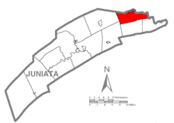
This township is located in northeastern Juniata County, with the West Branch of Mahantango Creek forming the northeastern boundary. According to the United States Census Bureau, the township has a total area of 19.9 square miles (51.5 km2), all land. [3]

Monroe Township is bordered by Snyder County to the north and east, Susquehanna and Greenwood Townships to the south, and Delaware and Fayette Townships to the west. The unincorporated community of Richfield is situated at the northern border of the township. Other communities in the township are Evendale, Kellerville, Stony Run, and Knousetown.

Pennsylvania Route 35 passes through the northern part of the township, connecting Evendale and Richfield. The highway leads west to Mifflintown on the Juniata River and east to Selinsgrove on the Susquehanna.

Demographics

Historical population
CensusPop.Note
1860 1,021
1870 1,0785.6%
1880 1,1254.4%
1890 1,092−2.9%
1900 1,078−1.3%
1910 1,011−6.2%
1920 963−4.7%
1930 1,0145.3%
1940 1,24122.4%
1950 1,2611.6%
1960 1,3214.8%
1970 1,4257.9%
1980 1,65115.9%
1990 1,8009.0%
2000 2,04213.4%
2010 2,2379.5%
2020 2,050−8.4%
2022 (est.)2,026 [2] −1.2%
U.S. Decennial Census [4]

As of the census [5] of 2000, there were 2,042 people, 712 households, and 571 families residing in the township.

The population density was 104.0 inhabitants per square mile (40.2/km2). There were 765 housing units at an average density of 39.0 per square mile (15.1/km2).

The racial makeup of the township was 99.17% White, 0.34% African American, 0.05% Native American, 0.10% from other races, and 0.34% from two or more races. Hispanic or Latino of any race were 0.34% of the population.

There were 712 households, out of which 39.3% had children under the age of eighteen living with them; 71.2% were married couples living together, 4.2% had a female householder with no husband present, and 19.7% were non-families. 16.3% of all households were made up of individuals, and 9.4% had someone living alone who was sixty-five years of age or older.

The average household size was 2.80 and the average family size was 3.13.

With the township, the population was spread out, with 28.0% of residents who were under the age of eighteen, 8.7% who were aged eighteen to twenty-four, 29.0% who were aged twenty-five to forty-four, 20.7% who were aged forty-five to sixty-four, and 13.6% who were sixty-five years of age or older. The median age was thirty-four years.

For every one hundred females, there were 104.4 males. For every one hundred females who were aged eighteen or older, there were 98.4 males.

The median income for a household in the township was $38,807, and the median income for a family was $41,731. Males had a median income of $30,064 compared with that of $22,102 for females.

The per capita income for the township was $16,477.

Approximately 6.3% of families and 7.8% of the population were living below the poverty line, including 8.0% of those who were under the age of eighteen and 11.2% of those who were aged sixty-five or older.

Related Research Articles

<span class="mw-page-title-main">Juniata Township, Bedford County, Pennsylvania</span> Township in Pennsylvania, United States

Juniata Township is a township that is located in Bedford County, Pennsylvania, United States. The population was 901 at the time of the 2020 census.

<span class="mw-page-title-main">Worth Township, Butler County, Pennsylvania</span> Township in Pennsylvania, United States

Worth Township is a township that is located in Butler County, Pennsylvania, United States. The population was 1,398 at the time of the 2020 census.

<span class="mw-page-title-main">Reed Township, Pennsylvania</span> Township in Pennsylvania, United States

Reed Township is a township in Dauphin County, Pennsylvania, United States. The population was 229 at the 2020 census, a decline from 239 in 2010.

<span class="mw-page-title-main">Miller Township, Huntingdon County, Pennsylvania</span> Township in Pennsylvania, United States

Miller Township is a township that is located in Huntingdon County, Pennsylvania, United States. The population was 457 at the time of the 2020 census.

<span class="mw-page-title-main">Porter Township, Huntingdon County, Pennsylvania</span> Township in Pennsylvania, United States

Porter Township is a township that is located in Huntingdon County, Pennsylvania, United States. The population was 1,907 at the time of the 2020 census.

<span class="mw-page-title-main">Todd Township, Huntingdon County, Pennsylvania</span> Township in Pennsylvania, United States

Todd Township is a township that is located in Huntingdon County, Pennsylvania, United States. The population was 895 at the time of the 2020 census.

<span class="mw-page-title-main">Greenwood Township, Juniata County, Pennsylvania</span> Township in Pennsylvania, United States

Greenwood Township is a township in Juniata County, Pennsylvania, United States. The population was 533 at the 2020 census, an increase over the figure of 617 tabulated in 2010.

<span class="mw-page-title-main">Lack Township, Juniata County, Pennsylvania</span> Township in Pennsylvania, United States

Lack Township is a township that is located in Juniata County, Pennsylvania, United States. The population was 637 at the time of the 2020 census.

<span class="mw-page-title-main">Mexico, Juniata County, Pennsylvania</span> Census-designated place in Pennsylvania, United States

Mexico is an unincorporated community and census-designated place (CDP) in Walker Township, Juniata County, Pennsylvania, United States.

<span class="mw-page-title-main">Richfield, Pennsylvania</span> Census-designated place in Pennsylvania, United States

Richfield is an unincorporated community and census-designated place (CDP) in Juniata and Snyder counties in Pennsylvania, United States. The population was 549 at the 2010 census.

<span class="mw-page-title-main">Tuscarora Township, Juniata County, Pennsylvania</span> Township in Pennsylvania, United States

Tuscarora Township is a township that is located in southwestern Juniata County, Pennsylvania, United States. The population was 1,131 at the time of the 2020 census.

<span class="mw-page-title-main">Leacock Township, Pennsylvania</span> Township in Pennsylvania, United States

Leacock Township is an American township that is located in east central Lancaster County, Pennsylvania. As of the 2020 census, the population of the township was 5,652, an increase over the figure of 5,220 tabulated in 2010.

<span class="mw-page-title-main">Huntington Township, Luzerne County, Pennsylvania</span> Township in Pennsylvania, United States

Huntington Township is an American township which is in Luzerne County, Pennsylvania. The population was 2,052 at the time of the 2020 census.

<span class="mw-page-title-main">Lake Township, Luzerne County, Pennsylvania</span> Township in Pennsylvania, United States

Lake Township is a township that is located in Luzerne County, Pennsylvania, United States. It is part of the Back Mountain, a 118-square mile region in northern Luzerne County. The population was 1,994 at the time of the 2020 census.

<span class="mw-page-title-main">Menno Township, Pennsylvania</span> Township in Pennsylvania, United States

Menno Township is a township in Mifflin County, Pennsylvania, United States. The population was 1,973 at the time of the 2020 census.

<span class="mw-page-title-main">Newton Hamilton, Pennsylvania</span> Borough in Pennsylvania, United States

Newton Hamilton is a borough in Mifflin County, Pennsylvania, United States. The population was 197 at the time of the 2020 census.

<span class="mw-page-title-main">North Manheim Township, Pennsylvania</span> Township in Pennsylvania, United States

North Manheim Township is a township that is located in Schuylkill County, Pennsylvania, United States. The population was 4,043 at the time of the 2020 census.

<span class="mw-page-title-main">Cherry Grove Township, Warren County, Pennsylvania</span> Township in Pennsylvania, United States

Cherry Grove Township is a township in Warren County, Pennsylvania, United States. The population at the 2020 census was 173, down from 216 in the 2010 census.

<span class="mw-page-title-main">Monroe Township, Wyoming County, Pennsylvania</span> Township in Pennsylvania, United States

Monroe Township is a township that is located in Wyoming County, Pennsylvania, United States. The population was 1,665 at the time of the 2020 census.

<span class="mw-page-title-main">Yoe, Pennsylvania</span> Borough in Pennsylvania, United States

Yoe is a borough in York County, Pennsylvania, United States. The population was 1,058 at the time of the 2020 census.

References

  1. "2016 U.S. Gazetteer Files". United States Census Bureau. Retrieved August 14, 2017.
  2. 1 2 3 4 Bureau, US Census. "City and Town Population Totals: 2020-2022". Census.gov. US Census Bureau. Retrieved January 31, 2024.
  3. 1 2 "Geographic Identifiers: 2010 Census Summary File 1 (G001): Monroe township, Juniata County, Pennsylvania". American Factfinder. U.S. Census Bureau. Archived from the original on February 13, 2020. Retrieved November 21, 2018.
  4. "Census of Population and Housing". Census.gov. Retrieved June 4, 2016.
  5. "U.S. Census website". United States Census Bureau . Retrieved January 31, 2008.

40°40′00″N77°07′59″W / 40.66667°N 77.13306°W / 40.66667; -77.13306