Igralishte | |
---|---|
Village | |
Coordinates: 41°34′N23°08′E / 41.567°N 23.133°E | |
Country | |
Province | Blagoevgrad Province |
Municipality | Strumyani Municipality |
Elevation | 819 m (2,687 ft) |
Population (2010) | |
• Total | 336 |
Time zone | EET (UTC+2) |
• Summer (DST) | EEST (UTC+3) |
Postal code | 2848 |
Area code(s) | (+359) 74348 |
Vehicle registration | E |
Igralishte is a village in Strumyani Municipality, in Blagoevgrad Province, in southwestern Bulgaria. [1]
Strumyani Municipality is a municipality in Blagoevgrad Province in Southwestern Bulgaria.
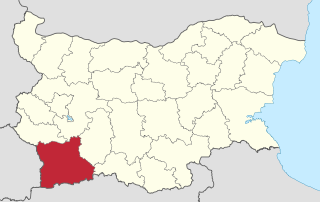
Blagoevgrad Province, also known as Pirin Macedonia is a province (oblast) of southwestern Bulgaria. It borders four other Bulgarian provinces to the north and east, to the Greek region of Macedonia to the south, and North Macedonia to the west. The province has 14 municipalities with 12 towns. Its principal city is Blagoevgrad, while other significant towns include Bansko, Gotse Delchev, Melnik, Petrich, Razlog, Sandanski, and Simitli.
Bulgaria, officially the Republic of Bulgaria, is a country in Southeast Europe. It is bordered by Romania to the north, Serbia and North Macedonia to the west, Greece and Turkey to the south, and the Black Sea to the east. The capital and largest city is Sofia; other major cities are Plovdiv, Varna and Burgas. With a territory of 110,994 square kilometres (42,855 sq mi), Bulgaria is Europe's 16th-largest country.
Igralishte Peak in Antarctica is named after the village.
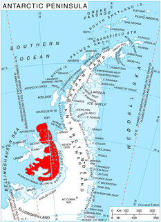
Igralishte Peak is the ice-covered peak rising to 1800 m in Havre Mountains, northern Alexander Island in Antarctica. It surmounts Hadzhiev Glacier to the northeast and Wubbold Glacier to the south. The feature is named after the settlement of Igralishte in Southwestern Bulgaria.
Antarctica is Earth's southernmost continent. It contains the geographic South Pole and is situated in the Antarctic region of the Southern Hemisphere, almost entirely south of the Antarctic Circle, and is surrounded by the Southern Ocean. At 14,200,000 square kilometres, it is the fifth-largest continent. For comparison, Antarctica is nearly twice the size of Australia. About 98% of Antarctica is covered by ice that averages 1.9 km in thickness, which extends to all but the northernmost reaches of the Antarctic Peninsula.
Polenitsa is a village in South West Bulgaria in Blagoevgrad Province, 159 km from the capital city of Sofia and 2 km from the spa resort of Sandanski. The village has a permanent population of 1150 people (2008).
Gostilya is a village in central northern Bulgaria, located in Dolna Mitropoliya municipality, Pleven Province. It was founded in 1890 by 133 families of Roman Catholic Banat Bulgarians from Stár Bišnov and Ivanovo in what was then Austria-Hungary. It was later also settled by Banat Swabians (see Germans in Bulgaria), Eastern Orthodox Bulgarians and Aromanians from Macedonia, as well as Banat Bulgarians from other villages. A school was built in 1893, the Roman Catholic church was opened in 1904 and the local community centre (chitalishte) was founded in 1926. Gostilya was once the poorest of the Banat Bulgarian villages in Bulgaria because it had a limited common. In 1939, the local Roman Catholic community numbered 1,091. 33 Banat Swabians left Gostilya in 1943 due to Nazi Germany's Heim ins Reich policy.
Dabnitsa is a village in Garmen Municipality, in Blagoevgrad Province, Bulgaria. It is situated in the Dabrash part of the Rhodope Mountains near Mesta river, 4 kilometers south-southeast of Garmen and 79 kilometers southeast of Blagoevgrad.
Belasitsa is a village in Petrich Municipality, in Blagoevgrad Province, Bulgaria.
Churicheni is a village in Petrich Municipality, in Blagoevgrad Province, Bulgaria.
Parvomay is a village in Petrich Municipality, in Blagoevgrad Province, Bulgaria.
Tonsko Dabe is a village in Petrich Municipality, in Blagoevgrad Province, Bulgaria.
Yakovo is a village in Petrich Municipality, in Blagoevgrad Province, Bulgaria.
Pirin (village) is a village in the municipality of Sandanski, in Blagoevgrad Province, Bulgaria.
Sugarevo is a village in the municipality of Sandanski, in Blagoevgrad Province, Bulgaria.
Cherniche is a village in Simitli Municipality, in Blagoevgrad Province, in southwestern Bulgaria.
Nikudin is a village in Strumyani Municipality, in Blagoevgrad Province, in southwestern Bulgaria.
Velyushtets is a village in Strumyani Municipality, in Blagoevgrad Province, in southwestern Bulgaria.
Bostanite is a former village in the municipality of Chuprene, in Vidin Province, in northwestern Bulgaria.
Karapelit is a village in the municipality of Dobrichka, in Dobrich Province, in northeastern Bulgaria.
Kotlentsi is a village in the municipality of Dobrichka, in Dobrich Province, in northeastern Bulgaria.
Polkovnik Minkovo is a village in the municipality of Dobrichka, in Dobrich Province, in northeastern Bulgaria.
Dolno Voyvodino is a village in the municipality of Haskovo, in Haskovo Province, in southern Bulgaria.
Bubino is a village in the municipality of Ivaylovgrad, in Haskovo Province, in southern Bulgaria.
Manastirishte is a village in Svoge Municipality, Sofia Province, western Bulgaria.
Coordinates: 41°34′N23°08′E / 41.567°N 23.133°E
A geographic coordinate system is a coordinate system that enables every location on Earth to be specified by a set of numbers, letters or symbols. The coordinates are often chosen such that one of the numbers represents a vertical position and two or three of the numbers represent a horizontal position; alternatively, a geographic position may be expressed in a combined three-dimensional Cartesian vector. A common choice of coordinates is latitude, longitude and elevation. To specify a location on a plane requires a map projection.
This Blagoevgrad Province, Bulgaria location article is a stub. You can help Wikipedia by expanding it. |