Ilha de Luanda

Last updated
Ilha do Cabo
Ilha de Luanda
Luanda 13.23266E 8.80761S.jpg
Ilha de Cabo, a sandspit off the shore of Luanda
Location Luanda Province, Angola
Thatched huts for tourists on Luanda Island. Ilha de Luanda.JPG
Thatched huts for tourists on Luanda Island.

Ilha do Cabo (English: Cape Island) typically known as Ilha de Luanda (English: Island of Luanda) is a spit [1] off the shore of Luanda, the capital of Angola, a country on the continents' southwestern coast. It consists of a low sandy strip formed by sedimentation. In administrative terms, the peninsula belongs to the municipality of Ingombota in the Luanda Province.

Contents

History

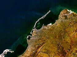
When Paulo Dias de Novais, a Portuguese navigator, arrived here in 1575 with several hundred soldiers and settlers, the island was inhabited by the Axi-lwanda, a subgroup of the Ambundu people which was tributary to the Kongo Empire. The island was an important location to collect zimbo, the shells that constituted the currency of the Kongo king before the arrival of the Portuguese. [2] The Portuguese settled here for a while, gaining control of the currency, before they decided to establish themselves on the mainland, opposite the island. They started to use the name of the African inhabitants as a name for the island and the town, spelling it first "Loanda" and then "Luanda".

The Ilha, as it is called colloquially by the population, is connected with the city through a narrow passage [3] and is located at the foot of the Fortress of São Miguel. This is an area where residents can get away from the stresses of the capital, especially on weekends. A wide variety of hotels and clubs with bars and restaurants, as well as flea markets and marinas attract visitors.

The first church built by the Portuguese in Angola, the church of Nossa Senhora do Cabo is located here. [4] It was erected by some 40 settlers in 1575, before they moved to the mainland in 1576, founding the present capital of Luanda.

Culture

The "União Mundo da Ilha" (a carnival group), [5] was founded in 1968 by residents of the island. The group has about 150 members that aim at Varina and Semba as their main style of dance.

The Clube Náutico da Ilha de Luanda sports club is situated on the island.

Well-known dishes from this area are Mufete and Muzongué (a type of broth). [2]

Related Research Articles

<span class="mw-page-title-main">Luanda</span> Capital of Angola

Luanda is the capital and largest city in Angola. It is Angola's primary port, and its major industrial, cultural and urban centre. Located on Angola's northern Atlantic coast, Luanda is Angola's administrative centre, its chief seaport, and also the capital of the Luanda Province. Luanda and its metropolitan area is the most populous Portuguese-speaking capital city in the world and the most populous Lusophone city outside Brazil, with over 8.3 million inhabitants in 2020.

<span class="mw-page-title-main">Community of Portuguese Language Countries</span> International organization

The Community of Portuguese Language Countries, also known as the Lusophone Commonwealth, is an international organization and political association of Lusophone nations across four continents, where Portuguese is an official language. The CPLP operates as a privileged, multilateral forum for the mutual cooperation of the governments, economies, non-governmental organizations, and peoples of the Lusofonia. The CPLP consists of 9 member states and 32 associate observers, located in Europe, South America, Asia, Africa and Oceania, totaling 37 countries and 4 organizations.

<span class="mw-page-title-main">Uíge Province</span> Province of Angola

Uíge is one of the eighteen Provinces of Angola, located in the northwestern part of the country. Its capital city is of the same name.

<span class="mw-page-title-main">Lubango</span> Municipality in Huila, Angola

Lubango, formerly known as Sá da Bandeira, is a municipality in Angola, capital of the Huíla Province, with a population of 914,456 in 2022. The city center had a population of 600,751 in 2014 making it the second-most populous city in Angola after the capital city Luanda.

<span class="mw-page-title-main">Angústias</span> Civil parish in Azores, Portugal

Angústias is one of the three freguesia that comprise the urban area of the city of Horta, on the island of Faial in the Portuguese archipelago of the Azores. This is an economically active, densely populated area. The population in 2011 was 2,418, in an area of 3.79 km2. Due to its commercial nature, the parish is one of the island's primary destinations for tourism, due to the concentration of historical sights and shopping. It contains the localities Caminho do Meio, Courelas, Pasteleiro, Port Pim, Termo da Igreja and Vigia.

<span class="mw-page-title-main">Pilar da Bretanha</span> Civil parish in Azores, Portugal

Pilar da Bretanha is a civil parish in the municipality of Ponta Delgada on the island of São Miguel, in the Portuguese archipelago of the Azores. It was de-annexed from the historical parish of Bretanha on 10 July 2002, along with Ajuda da Bretanha. The population in 2011 was 624, in an area of 6.07 square kilometres (2.34 sq mi). It contains the localities Casa Telhada, Covas, João Bom and Pilar.

<span class="mw-page-title-main">Ribeira Grande, Azores</span> Municipality in Azores, Portugal

Ribeira Grande is a municipality in the northern part of the island of São Miguel in the Portuguese Azores. The population in 2011 was 32,112, in an area of 180.15 km2. The municipal seat is located in the civil parish of Matriz, with a population of about 4000 inhabitants, part of the urbanized core of what is commonly referred to as the city of Ribeira Grande.

<span class="mw-page-title-main">Island of Mozambique</span> Historically significant island off the northeastern coast of Mozambique

The Island of Mozambique lies off northern Mozambique, between the Mozambique Channel and Mossuril Bay, and is part of Nampula Province. Prior to 1898, it was the capital of colonial Portuguese East Africa. With its rich history and sandy beaches, the Island of Mozambique is a UNESCO World Heritage site and one of Mozambique's fastest-growing tourist destinations. It has a permanent population of approximately 14,000 people and is served by nearby Lumbo Airport on the Nampula mainland. The name of the country, Mozambique, is derived from the name of this island.

<span class="mw-page-title-main">Álvaro I of Kongo</span> Mwene Kongo

Álvaro I Nimi a Lukeni lua Mvemba was a Manikongo, or king of Kongo, from 1568 to 1587 and the founder of the Kwilu dynasty.

<span class="mw-page-title-main">Kingdom of Kongo</span> 1390–1914 state in Central Africa; Portuguese vassal from 1857

The Kingdom of Kongo was a kingdom located in central Africa in present-day northern Angola, the western portion of the Democratic Republic of the Congo, and the Republic of the Congo. At its greatest extent it reached from the Atlantic Ocean in the west to the Kwango River in the east, and from the Congo River in the north to the Kwanza River in the south. The kingdom consisted of several core provinces ruled by the Manikongo, the Portuguese version of the Kongo title Mwene Kongo, meaning "lord or ruler of the Kongo kingdom", but its sphere of influence extended to neighbouring kingdoms, such as Ngoyo, Kakongo, Loango, Ndongo and Matamba, the latter two located in what is Angola today.

Aguinaldo Fonseca was a Cape Verdean poet.

The precolonial history of Angola lasted until Portugal annexed the territory as a colony in 1655.

The colonial history of Angola is usually considered to run from the appearance of the Portuguese under Diogo Cão in 1482 (Congo) or 1484 until the independence of Angola in November 1975. Settlement did not begin until Novais's establishment of São Paulo de Loanda (Luanda) in 1575, however, and the Portuguese government only formally incorporated Angola as a colony in 1655 or on May 12, 1886.

The Portuguese colony of Angola was founded in 1575 with the arrival of Paulo Dias de Novais with a hundred families of colonists and four hundred soldiers. Luanda was granted the status of city in 1605. The fortified Portuguese towns of Luanda and Benguela.

<span class="mw-page-title-main">Portuguese Angola</span> 1575–1975 Portuguese possession in West Africa

Portuguese Angola refers to Angola during the historic period when it was a territory under Portuguese rule in southwestern Africa. In the same context, it was known until 1951 as Portuguese West Africa.

Ingombota is one of the six urban districts that make up the municipality of Luanda, in the province of Luanda, the capital city of Angola. Ingombota is home to the central business district of Luanda, Angola. The economic, political and symbolic center of the city and the nation, it is Luanda's oldest district. The district is home to most of Luanda's prominent hotels and office towers.

Igreja da Nossa Senhora do Cabo is a church in the Ingombota District of Luanda, Angola. It is the oldest church in the city of Luanda, founded in 1575 by Portuguese traders, who dedicated it to Our Lady of the Immaculate Conception. After the reconquest of territory from the Dutch in 1648, reconstruction of the church started, and when completed in 1669 it was given its current name. In 1854, it became a parish church. The stone church is characterized by having a secular cross and an elegant side tower.

<span class="mw-page-title-main">Nossa Senhora do Carmo</span> Church in Luanda, Angola

Igreja e Convento de Nossa Senhora do Carmo, also Igreja do Carmo or Carmo's Church, is a church and convent complex in Luanda, Angola. Thanks to its good condition, the church is considered to be one of the country's most important religious monuments.

<span class="mw-page-title-main">Luanda Bay</span> Body of water

Luanda Bay is a body of water, located in front of the city of Luanda, capital of Angola. In front of the bay are located several monuments of great historical value, such as the Banco de Angola Building and the Church of Nossa Senhora da Nazaré.

The Igreja de Jesus, also Igreja dos Jesuítas, is a landmark in the Ingombota District of Luanda, Angola, adjacent to the Presidential Palace in the cidade alta neighborhood. It is the former church of the Jesuit college established in the city in the early 17th century. It has a fine baroque façade and a richly decorated interior.

References

  1. "Map of Luanda". Archived from the original on 2013-04-19. Retrieved 2013-03-01.
  2. 1 2 "Ilha de Luanda e suas tradições (retrieved - 27/09/2010)". Archived from the original on 2016-03-03. Retrieved 2018-07-28.
  3. Ponte que liga marginal à Ilha de Luanda será inaugurada recuperado 18 de agosto 2011 (in Portuguese)
  4. Igreja da Nossa Sra. do Cabo (in Portuguese)
  5. Angop: União Mundo da Ilha abre desfile da classe A do Carnaval de Luanda retrieved February 10, 2011 (Portuguese)

Commons-logo.svg Media related to Ilha do Cabo at Wikimedia Commons

Coordinates: 8°46′43″S13°14′37″E / 8.77861°S 13.24361°E / -8.77861; 13.24361