Maianga

Last updated
Maianga
View over Luanda 6.JPG
New Construction in Maianga
Coordinates: 8°49′05″S13°13′44″E / 8.81806°S 13.22889°E / -8.81806; 13.22889
Country Angola
Province Luanda
Founded1576
Area
  Total24.7 km2 (9.53 sq mi)
Elevation
6 m (20 ft)
Population
 (2020) [1]
  Total319,000
  Density13,000/km2 (33,000/sq mi)
Time zone +1
HDI (2019)0.697 [2]
Medium

Maianga is one of the six municipalities of the administrative division of the province of Luanda, Angola. In 2011, as part of a restructuring of Luanda's regional government, the municipality was designated as one of Luanda's six urban districts. [3] The area is one of the older quarters of Luanda and was established before independence. The area is best known for Quatro de Fevereiro Airport and its strong musical culture.

Contents

History

Informal Settlements in Maianga Maianga, Luanda, Angola.JPG
Informal Settlements in Maianga

The name Maianga comes from the word Kimbundu Mazanga which means ponds. Before being urbanized, Maianga was an area known as a place that was routinely submerged by rainwater. [4] The area was attractive to residents on account of the existence of two wells called Maianga do Rei and Maianga do Povo. The wells are located in the neighborhoods of Prenda and Cassenda. [5]

The northern part of Maianga is an extension of the colonial center of Luanda. The neighborhoods in the northern part of Maianga are formally built and set on paved streets with city services. Neighborhoods along Avenue Revolução de Outubro and to the south of Quatro de Fevereiro Airport are densely populated, informally built and set on dirt roads with limited access to fresh water and electricity. The area grew rapidly during the Angolan Civil War and in the years after Angola's independence from Portugal. The area is now fully urbanized and is undergoing an extensive amount of construction as a result of Luanda's prosperous real-estate economy. Several large office towers and a multi-story shopping center were built between 2018 and 2020 at the intersection of Largo de Rio de Janeiro and Ho Chi Minh Avenue. Maianga is also home to Luanda's water treatment plant and a large power generation plant.

Orientation

Maianga, is located on the southern edge of the center of Luanda. The neighborhood is bounded by dos Heróis Street to the west, Kwame Nkrumah Street and Avenue Deolinda Rodrigues to the north, the Cambamba River to the east and south and da Fapa Street to the south. Due to the informal nature of construction and street layouts, the southern and eastern borders have loose definitions. In recent years dos Heróis Street has been upgraded into a multi-lane closed access highway known as the EN-100 Highway which connects the Port of Luanda to the southern suburbs of the city and on to the port city of Lobito. The northern part of Maianga is more formally urbanized while the southern and eastern portions are largely defined by unpermitted construction and dirt lanes.

The district is bordered to the north by the urban districts of Ingombota and Rangel, to the south by Samba and to the east by the municipality of Quilamba Quiaxi. It is one of the six urban districts of the City of Luanda.

Culture

As a historic and working-class neighborhood of Luanda, the city has a strong and important history of musical innovation. Several famous Angolan musicians hail from Maianga including Calibrados and Tony Mad.

Transportation

Quatro de Fevereiro Airport is located in the District of Maianga. The airport was constructed in 1951 in order to serve the region. At the time of its construction Maianga was largely made up of farmland and informal settlements. With the explosive growth of Luanda in the post-colonial period, the airport is now located well within the urban center. Due to space constraints and outdated facilities, Angola International Airport 40 kilometers to the southwest of the center of Luanda and will replace Quatro de Fevereiro Airport as the primary point of entry to Angola for international flights. The Airport is connected to the Ingombota by the Avenue Revolução de Outubro.

Administrative Division

Neighborhoods

Related Research Articles

<span class="mw-page-title-main">Luanda Province</span> Province of Angola

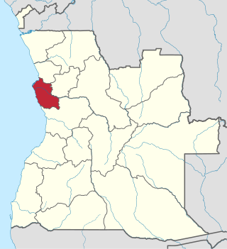
Luanda is a province of Angola. It covers an area of 18,835 km2, and had a population of 6,945,386 at the Census of 16 May 2014. The latest official estimate is 8,247,688.

<span class="mw-page-title-main">Moxico Province</span> Province of Angola

Moxico or Moshiko is the largest province of Angola. It has an area of 223,023 square kilometres (86,110 sq mi), and covers 18% of the landmass of Angola. The province has a population of 758,568 and a population density of approximately 3.4 residents per km², making it one of the most sparsely populated areas of Angola. The population of the province is in flux; displaced residents have slowly returned to Moxico since the end of the Angolan Civil War in 2002. The war left Moxico as one of the most landmine-contaminated places in the world. The governor of the province is Gonçalves Manuel Muandumba.

<span class="mw-page-title-main">Quatro de Fevereiro Airport</span> Airport in Luanda, Angola

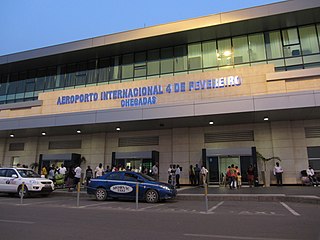
Quatro de Fevereiro International Airport, is the main international airport of Angola. It is located in the southern part of the capital Luanda, situated in the Luanda Province. Quatro de Fevereiro means 4th of February, which is an important national holiday in Angola, marking the start of the armed struggle against the Portuguese colonial regime on 4 February 1961. In 2009, about 1.8 million passengers were counted.

<span class="mw-page-title-main">C.D. Primeiro de Agosto</span> Football club

Clube Desportivo 1º de Agosto is a multisports club from Luanda, Angola. The club, founded 1 August 1977, is attached to the Angolan armed forces, which is its sponsor. Its main team competes in men's football, and its professional basketball team is also noteworthy within the club. The club's colors are red and black. The club won its first title in football, the Angolan League, in 1979. and in basketball in 1980. Handball and Volleyball have also won many titles to the club.

<span class="mw-page-title-main">Girabola</span> Football league

Girabola, or Campeonato Nacional de Futebol em Séniores Masculinos, is the top division of Angolan football. It is organized by the Angolan Football Federation.

<span class="mw-page-title-main">Progresso Associação do Sambizanga</span> Football club

Progresso Associação do Sambizanga is an Angolan football club based in Luanda. The club was founded in 1975, as a result of a merger of three clubs: Juventude Unida do Bairro Alfredo(JUBA), Juventista and Vaza.

Pedro de Castro van Dúnem, also known as Comandante Loy, was an Angolan politician. He served in various leading functions within the MPLA during the Angolan liberation struggle against Portuguese colonial rule and within the country's government after achieving independence.

<span class="mw-page-title-main">Sambizanga</span> Place in Luanda, Angola

Sambizanga is one of the six urban districts that make up the municipality of Luanda, in the province of Luanda, Angola.

<span class="mw-page-title-main">Ilha de Luanda</span>

Ilha do Cabo typically known as Ilha de Luanda is a spit off the shore of Luanda, the capital of Angola, a country on the continents' southwestern coast. It consists of a low sandy strip formed by sedimentation. In administrative terms, the peninsula belongs to the municipality of Ingombota in the Luanda Province.

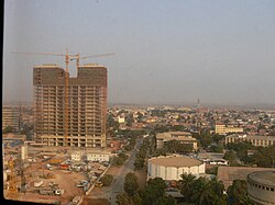
Ingombota is one of the six urban districts that make up the municipality of Luanda, in the province of Luanda, the capital city of Angola. Ingombota is home to the central business district of Luanda, Angola. The economic, political and symbolic center of the city and the nation, it is Luanda's oldest district. The district is home to most of Luanda's prominent hotels and office towers.

<span class="mw-page-title-main">Rangel, Luanda</span> Urban District of Luanda

Rangel is one of the six urban districts that make up the municipality of Luanda, in the province of Luanda, the capital of Angola. The Rangel District is one of the older and more urbanized in Metropolitan Luanda. The district has an area of 6.2 square kilometers. The district is best known as the home of Americo Boavida University Hospital as well as several large sporting facilities including Pavilhão da Cidadela, Pavilhão Anexo and Pavilhão Anexo II.

Nelsa Alves is an Angolan model and was the competitor for Miss Universe 2009. She won the title of Miss Ingombota on her debut as a model, and subsequently sought to promote good causes.

The Municipality of Luanda is one of the nine municipalities that make up the province of Luanda, Angola. It covers roughly 116 km2 and includes Ilha de Luanda. The population was 2,194,747 at the 2014 census and is projected to be 2,571,861 in 2019 per Instituto Nacional de Estatística, República de Angola.

The 2002 Girabola was the 24th season of top-tier football competition in Angola. The season ran from 23 February to 20 October 2002. Petro de Luanda were the defending champions.

Fly540 Angola was a subsidiary of Fly540 that was based at Quatro de Fevereiro Airport in Luanda and Cabinda Airport in Cabinda, Angola. Parent company Fastjet suspended its operations in April 2014 pending restructuring, although it never resumed flights.

Maria de Fátima - better known by her pen name Cho do Guri - was an Angolan poet and writer.

<span class="mw-page-title-main">2000 ASA Pesada Antonov An-24 crash</span> Aviation accident

The 2000 ASA Pesada Antonov An-24 crash occurred on 15 November 2000 when an Antonov An-24 registered as D2-FCG operated by Angolan airliner ASA Pesada crashed shortly after taking off from Quatro de Fevereiro Airport in Angola's capital Luanda. The aircraft was carrying 52 passengers and 5 crewmembers and was heading to Yuri Gagarin Airport in Namibe Province, Angola. All 57 people on board were killed in the crash.

The Luanda Light Rail is a proposed light rail line to be built in the Angolan capital city Luanda, at a projected cost of US $3 billion.

References

  1. https://web.archive.org/web/20110724181202/http://www.gpl.gv.ao/municipios/municipioINGOMBOTA.doc [ bare URL ]
  2. "Sub-national HDI – Area Database – Global Data Lab". hdi.globaldatalab.org. Retrieved 2018-09-13.
  3. "Subdivisions of Angola in local language Portuguese" (in German). ANGOP. Archived from the original on 2010-11-23. Retrieved 2013-05-15.
  4. "Definição ou significado de maianga no Dicionário Infopédia da Língua Portuguesa". Infopédia - Dicionários Porto Editora (in European Portuguese). Retrieved 2018-05-15.
  5. "Angola: Distrito urbano da Maianga vai ganhar Postos de Transformação de Energia". ANGOP (in European Portuguese).