The Mississippi River is the second-longest river and chief river of the second-largest drainage system on the North American continent, second only to the Hudson Bay drainage system. From its traditional source of Lake Itasca in northern Minnesota, it flows generally south for 2,320 miles (3,730 km) to the Mississippi River Delta in the Gulf of Mexico. With its many tributaries, the Mississippi's watershed drains all or parts of 32 U.S. states and two Canadian provinces between the Rocky and Appalachian mountains. The main stem is entirely within the United States; the total drainage basin is 1,151,000 sq mi (2,980,000 km2), of which only about one percent is in Canada. The Mississippi ranks as the fourteenth-largest river by discharge in the world. The river either borders or passes through the states of Minnesota, Wisconsin, Iowa, Illinois, Missouri, Kentucky, Tennessee, Arkansas, Mississippi, and Louisiana.

Iliamna is a census-designated place (CDP) in Lake and Peninsula Borough, Alaska, United States. The population was 109 at the 2010 census, up from 102 in 2000.

Pedro Bay is a census-designated place (CDP) in Lake and Peninsula Borough, Alaska, United States. The population was 42 at the 2010 census, down from 50 in 2000.
The Raritan River is a major river of New Jersey. Its watershed drains much of the mountainous area of the central part of the state, emptying into the Raritan Bay on the Atlantic Ocean.
The Alaska Highway was constructed during World War II to connect the contiguous United States to Alaska across Canada. It begins at the junction with several Canadian highways in Dawson Creek, British Columbia, and runs to Delta Junction, Alaska, via Whitehorse, Yukon. When it was completed in 1942, it was about 2,700 kilometres (1,700 mi) long, but in 2012, it was only 2,232 km (1,387 mi). This is due to the continuing reconstruction of the highway, which has rerouted and straightened many sections. The highway opened to the public in 1948. Once legendary for being a rough, challenging drive, the highway is now paved over its entire length. Its component highways are British Columbia Highway 97, Yukon Highway 1 and Alaska Route 2.

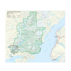
Lake Clark National Park and Preserve is an American national park in southwest Alaska, about 100 miles (160 km) southwest of Anchorage. The park was first proclaimed a national monument in 1978, then established as a national park and preserve in 1980 by the Alaska National Interest Lands Conservation Act. The park includes many streams and lakes vital to the Bristol Bay salmon fishery, including its namesake Lake Clark. A wide variety of recreational activities may be pursued in the park and preserve year-round. The park protects rainforests along the coastline of Cook Inlet, alpine tundra, glaciers, glacial lakes, major salmon-bearing rivers, and two volcanoes, Mount Redoubt and Mount Iliamna. Mount Redoubt is active, erupting in 1989 and 2009. The wide variety of ecosystems in the park mean that virtually all major Alaskan animals, terrestrial and marine, may be seen in and around the park. Salmon, particularly sockeye salmon, play a major role in the ecosystem and the local economy. The Kvichak River is the world's most productive watershed for sockeye salmon. Large populations of brown bears are attracted to feed on the spawning salmon in the Kijik River and at Silver Salmon Creek. Bear watching is a common activity in the park.

Iliamna Lake or Lake Iliamna is a lake in southwest Alaska, at the north end of the Alaska Peninsula, between Kvichak Bay and Cook Inlet, about 100 miles (160 km) west of Seldovia, Alaska.

Lake Shore Boulevard is a major arterial road running along more than half of the Lake Ontario waterfront in the city of Toronto, Ontario, Canada. Prior to 1998, two segments of Lake Shore Boulevard were designated as part of Highway 2, with the highway following the Gardiner Expressway between these two sections.
M-35 is a state trunkline highway in the Upper Peninsula (UP) of the US state of Michigan. It runs for 128 miles (206 km) in a general north–south direction and connects the cities of Menominee, Escanaba, and Negaunee. The southern section of M-35 in Menominee and Delta counties carries two additional designations; M-35 forms a segment of the Lake Michigan Circle Tour, and it is the UP Hidden Coast Recreational Heritage Trail, which is a part of what is now called the Pure Michigan Byways Program. Along the southern section, the highway is the closest trunkline to the Green Bay, a section of Lake Michigan. The northern section of the highway turns inland through sylvan areas of the UP, connecting rural portions of Delta and Marquette counties.

Lycoming Creek is a 37.5-mile-long (60.4 km) tributary of the West Branch Susquehanna River located in Tioga and Lycoming counties in Pennsylvania in the United States.

Transportation in the Commonwealth of Virginia is by land, sea and air. Virginia's extensive network of highways and railroads were developed and built over a period almost 400 years, beginning almost immediately after the founding of Jamestown in 1607, and often incorporating old established trails of the Native Americans.

The Millstone River is a 38.6-mile-long (62.1 km) tributary of the Raritan River in central New Jersey in the United States.
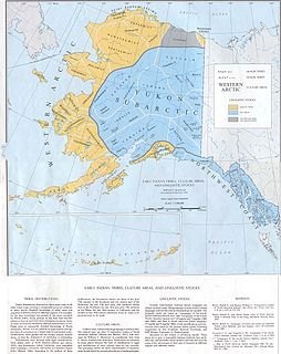
The Denaʼina, or formerly Tanaina, are an Alaska Native Athabaskan people of the Athabaskan-speaking ethnolinguistic group. They are the original inhabitants of the south central Alaska region ranging from Seldovia in the south to Chickaloon in the northeast, Talkeetna in the north, Lime Village in the Northwest and Pedro Bay in the Southwest. The Denaʼina homeland is more than 41,000 square miles in area. They arrived in the Southcentral Alaska sometime between 1,000 and 1,500 years ago. They were the only Alaskan Athabaskan group to live on the coast. Denaʼina culture is a hunter-gatherer culture and have a matrilineal system. The Iditarod Trail's antecedents were the native trails of the Denaʼina and Deg Hitʼan Athabaskan Indians and the Inupiaq Eskimos.

People in the San Francisco Bay Area rely on a complex multimodal transportation infrastructure consisting of roads, bridges, highways, rail, tunnels, airports, seaports, and bike and pedestrian paths. The development, maintenance, and operation of these different modes of transportation are overseen by various agencies, including the California Department of Transportation (Caltrans), the Association of Bay Area Governments, San Francisco Municipal Transportation Agency, and the Metropolitan Transportation Commission. These and other organizations collectively manage several interstate highways and state routes, two subway networks, two commuter rail agencies, eight trans-bay bridges, transbay ferry service, local bus service, three international airports, and an extensive network of roads, tunnels, and bike paths.

Pittsburgh, surrounded by rivers and hills, has a unique transportation infrastructure that includes roads, tunnels, bridges, railroads, inclines, bike paths, and stairways.

Southwest Alaska is a region of the U.S. state of Alaska. The area is not exactly defined by any governmental administrative region(s); nor does it always have a clear geographic boundary.
There were several historic bridges around the metro Atlanta, Georgia area, for which many of its current-day roads are named. Many of them originated as ferries, dating back to the 1820s and 1830s, and carrying travelers across the Chattahoochee River and several other smaller rivers. Several were also covered bridges, very few of which remain as historic sites.

Historically, the harbor was the key to the Hampton Roads area's growth, both on land and in water-related activities and events. Ironically, the harbor and its tributary waterways were both important transportation conduits and obstacles to other land-based commerce and travel. For hundreds of years, state and community leaders have worked to develop solutions to accommodate both.

Transportation in Lycoming County, Pennsylvania has a long and varied history. The area was settled in the mid 1700s. Transportation was mostly using the Susquehanna River and railroad as Williamsport was a travel hub or center for Central Pennsylvania.

Iliamna Bay is a bay along the southeastern coast of the Alaska Peninsula. It is below the Chigmit Mountains. Old Iliamna is miles away and the Iliamna River are north of it. Cottonwood Bay borders it to the west and Cook Inlet to the south. Augustine Volcano, an island, is south of it.