Bluffdale is a city in Salt Lake and Utah counties in the U.S. state of Utah, located about 20 miles (32 km) south of Salt Lake City. As of the 2020 census, the city population was 17,014.

The Mojave River is an intermittent river in the eastern San Bernardino Mountains and the Mojave Desert in San Bernardino County, California, United States. Most of its flow is underground, while its surface channels remain dry most of the time, except for the headwaters and several bedrock gorges in the lower reaches.

The Mormon Trail is the 1,300-mile (2,100 km) long route from Illinois to Utah on which Mormon pioneers traveled from 1846–47. Today, the Mormon Trail is a part of the United States National Trails System, known as the Mormon Pioneer National Historic Trail.

The Sweetwater River is a 238-mile (383 km) long tributary of the North Platte River, in the U.S. state of Wyoming. As a part of the Mississippi River system, its waters eventually reach the Gulf of Mexico.
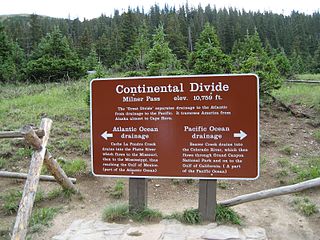
Milner Pass, elevation 10,759 ft (3,279 m) is a mountain pass in the Rocky Mountains of northern Colorado in the United States. It is located on the continental divide in the Front Range, within Rocky Mountain National Park, along the boundary between Larimer and Grand counties. The pass provides the passage over the continental divide for US 34, also known as Trail Ridge Road between Estes Park and Grand Lake. The pass is not, however, the high point on Trail Ridge Road, which crests at 12,183 ft (3,713 m) east of the pass within Rocky Mountain National Park. Along with the rest of Trail Ridge Road, the pass is generally closed in winter from the first heavy snow fall until the opening of the road around Memorial Day. The gentle pass divides the headwaters of the Cache la Poudre River and several creeks near the headwaters of the Colorado River to the west. The road near the pass provides a panoramic view of the Never Summer Mountains to the west.
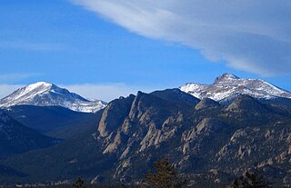
The Mummy Range is a mountain range in the Rocky Mountains of northern Colorado in the United States. The range is a short subrange of the Front Range located in southwestern Larimer County northwest of the town of Estes Park. It is located largely within Rocky Mountain National Park, extending north from Trail Ridge Road approximately 15 mi (24 km). The Arapaho name is "nooku-bee3ei-no," which translates to "White Owls."

The Collegiate Peaks Wilderness is a 168,000-acre (680 km2) area located in central Colorado between Leadville and Buena Vista to the east and Aspen to the west and Crested Butte to the southwest. Most of the area is in the San Isabel and Gunnison National Forests, with a smaller area in the White River National Forest southeast of Aspen. Most of the area is in northwest Chaffee County with smaller portions in Gunnison, Pitkin, and Lake counties.

The Arapaho National Recreation Area (ANRA) is a United States national recreation area located near the headwaters of the Colorado River in north central Colorado adjacent to Rocky Mountain National Park. ANRA is under the jurisdiction of the Arapaho-Roosevelt National Forest. ANRA contains five lakes in the upper Colorado River Valley:

The Mount Massive Wilderness is a federally designated wilderness area in the Sawatch Range, located in the U.S. state of Colorado. It is operated jointly by the United States Forest Service and the Fish and Wildlife Service as part of the San Isabel National Forest and the Leadville National Fish Hatchery. It is 30,540 acres (123.6 km2) in size, with 27,980 acres (113.2 km2) in San Isabel National Forest and 2,560 acres (10.4 km2) in Leadville National Fish Hatchery, and it was designated by the US Congress in 1980. The name comes from Mount Massive, the second highest peak in Colorado, located inside the wilderness. Elevations in the wilderness range from 9,700 feet (3,000 m) to 14,421 feet (4,396 m). It is the only federally designated wilderness area within the National Fish Hatchery System.
Snowmass Peak in the U.S. state of Colorado dominates the view from Snowmass Lake. It is often mistaken for Snowmass Mountain, the thirty-fourth highest mountain peak in the state, as well as for Hagerman Peak. Snowmass Peak is not really a peak but the lower end of Hagerman Peak's east ridge. Natural forced perspective causes the optical illusion that Snowmass Peak is higher than Hagerman Peak though it is actually 221 ft shorter than Hagerman's summit. This illusion combined with its striking rise behind Snowmass Lake justifies it being a named point on USGS topographical maps. It is located in the Elk Mountains, within the Maroon Bells-Snowmass Wilderness of the White River National Forest. It lies along the border between Pitkin and Gunnison counties, west of Aspen and southwest of the town of Snowmass Village.

Forester Pass is a mountain pass in the Sierra Nevada. Located on the Kings-Kern Divide and on the boundary between Sequoia National Park and Kings Canyon National Park, Forester Pass connects the drainages of Bubbs Creek and the Kern River. The pass is traversed by the John Muir Trail and the Pacific Crest Trail, which are coincident between Crabtree Meadows and Tuolumne Meadows. At 13,153 feet (4,009 m), Forester Pass is the highest point along the Pacific Crest Trail. It is also the southernmost of the six high mountain passes above 11,000 feet along the John Muir Trail, with Donohue Pass, Muir Pass, Mather Pass, Pinchot Pass, and Glen Pass.

The Cedar River is a 38.5-mile-long (62.0 km) river in the central Adirondacks, in Hamilton County, New York. It rises at the outlet of Cedar Lake in the Town of Arietta and flows northeast into the Town of Lake Pleasant, where it passes through the Cedar River Flow. Continuing northeast and east, it passes through the Town of Indian Lake and remote corners of the Towns of Minerva and Newcomb to join the Hudson River northeast of the hamlet of Indian Lake. The Northville-Placid Trail goes past the Cedar Lakes and along the Cedar River to the flow.

Benham Falls are rapids of the Deschutes River located between Sunriver and Bend, Oregon, United States. With a pitch of 22.5°, they are rated Class 5 for watercraft, and are the largest falls on the upper Deschutes.

The Eagles Nest Wilderness is a U.S. Wilderness Area located in the Gore Range near Vail, Copper Mountain, Frisco, Silverthorne, and Heeney, in Summit and Eagle Counties, Colorado. Eagles Nest Wilderness falls within the jurisdiction of Dillon Ranger District and Holy Cross Ranger District, White River National Forest. The 135,114-acre (546.79 km2) wilderness with 180 miles (290 km) of trails was established in 1976. In 2010, additional lands were proposed for wilderness protection under the Hidden Gems proposal, affecting Elliot Ridge, Tenmile, and Lower Piney areas of Summit and Eagle Counties.

The Holy Cross Wilderness is a U.S. Wilderness Area located in San Isabel and White River national forests near Leadville, Minturn, Avon, Edwards, Eagle, and Vail. The 122,797-acre (496.94 km2) wilderness with 164 miles (264 km) of trails was established in 1980. The wilderness was named after its highest peak, 14,005-foot (4,269 m) Mount of the Holy Cross.

The Hunter–Fryingpan Wilderness is a U.S. Wilderness Area located in White River National Forest east of Aspen, Colorado. The 82,026-acre (331.95 km2) wilderness established in 1978 includes the headwaters of Hunter Creek and the Fryingpan River plus many peaks of the Williams Mountains. It borders on the Mount Massive Wilderness to the east, separated only by the continental divide. There are 50 miles (80 km) of trails in the wilderness area.
Linkins Lake is an alpine lake in Pitkin County, Colorado, United States, located high in the Sawatch Range in the Hunter-Fryingpan Wilderness of White River National Forest. The lake is accessible via a 0.6 miles (0.97 km) trail from State Highway 82 west of Independence Pass.

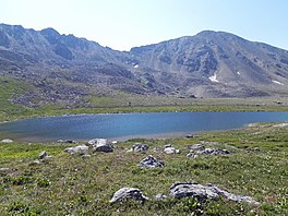
Lost Man Lake is an alpine lake in Pitkin County, Colorado, United States, located high in the Sawatch Range in the Hunter-Fryingpan Wilderness of White River National Forest. The lake is accessible via the Lost Man Loop Trail from State Highway 82 west of Independence Pass. The lake is over a pass and north of Independence Lake and northeast of Geissler Mountain. Lost Man Lake is larger than Independence, but only its east side is open. The trail continues by the lake into high alpine meadows in the upper valley, and to its west terminus at Lost Man Campground. Views down Lost Man Creek valley are worth a look, and a great place to scan high slopes and ridges for mountain goats, bighorn sheep and elk.

Lake Thomas A Edison is a reservoir in the Sierra National Forest and in Fresno County, California. It is in the Sierra Nevada, and near the Pacific Crest Trail.