Related Research Articles

Pocatello Regional Airport is a city-owned, public-use airport in the western United States, located in Bannock County, Idaho, seven nautical miles (13 km) northwest of central Pocatello.
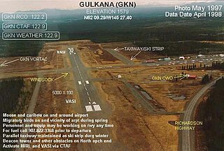
Gulkana Airport is a state owned, public use airport located four nautical miles northeast of the central business district of Gulkana, in the Valdez-Cordova Census Area of the U.S. state of Alaska. It is also and five miles (8 km) northeast of Glenallen. Scheduled passenger service is subsidized by the Essential Air Service program.

Tanglefoot Seaplane Base is a privately owned, public-use seaplane base in Bonner County, Idaho, United States. It is located at Priest Lake, on west shore of Cavanaugh Bay.
Cavanaugh Bay Airport is a public use airport located three nautical miles (6 km) north of the central business district of Coolin, in Bonner County, Idaho, United States. It is owned by the State of Idaho, Idaho Transportation Department, Division of Aeronautics. The airport is located on the east side of Priest Lake, at the south end of Cavanaugh Bay.
Priest Lake USFS Airport is a public use airport located three nautical miles south of the central business district of Nordman, in Bonner County, Idaho, United States. It is owned by the United States Forest Service. The airport is located at the west side of Priest Lake.
Bear Creek 3 Airport is a public-use airport located three nautical miles west of the central business district of Bear Creek, in the Yukon-Koyukuk Census Area of the U.S. state of Alaska. Bear Creek 3 is 40 nautical miles north of McGrath Airport.
Condon USFS Airport is a public use airport located one nautical mile northwest of the central business district of Condon, in Missoula County, Montana, United States. It is owned by the United States Forest Service (USFS).

Driggs–Reed Memorial Airport is a city-owned public-use airport located one nautical mile (1.85 km) north of the central business district of Driggs, a city in Teton County, Idaho, United States. This airport is included in the FAA's National Plan of Integrated Airport Systems for 2009–2013, which categorized it as a general aviation facility.
Alsek River Airport is a public-use airport located 44 nautical miles (81 km) southeast of the central business district of Yakutat, a city and borough in the U.S. state of Alaska. It is owned by the USFS Tongass National Forest. As per Federal Aviation Administration records, the airport had 507 passenger boardings (enplanements) in calendar year 2008.

Chamberlain USFS Airport is a public use airport located at Chamberlain Guard Station, in Idaho County, Idaho, United States. The airport is owned by the U.S. Forest Service. It is located near Chamberlain Creek in the Payette National Forest.
Cabin Creek USFS Airport is a public-use airport in Valley County, Idaho, United States. It is located 17 nautical miles east of Big Creek Ranger Station. The airport is owned by the U.S. Forest Service. The airstrip is near Cabin Creek in the Payette National Forest.
Indian Mountain LRRS Airport is a military airstrip located south of Utopia Creek, in the Yukon–Koyukuk Census Area of the U.S. state of Alaska. The airstrip is also located 15.8 miles (25.4 km) east-southeast of Hughes, Alaska. It is not open for public use.
Big Creek Airport is a state-owned public-use airstrip in Valley County, Idaho, United States. It is located 12 nautical miles northeast of Yellow Pine, Idaho and 17 nautical miles west of the Cabin Creek USFS Airport . The airstrip is actually on Forest Service managed land. The state of Idaho Division of Aeronautics has a special use permit to perform annual maintenance on the strip and some facilities. The airport is located at the Big Creek Ranger Station in Payette National Forest, adjacent to the Big Creek Campground. The airstrip serves the Big Creek Lodge.
Dixie USFS Airport is a public-use U.S. Forest Service airport located three nautical miles southwest of the central business district of Dixie, in Idaho County, Idaho, United States.
Wilson Bar USFS Airport is a public-use U.S. Forest Service airport located eight nautical miles south of the central business district of Dixie, in Idaho County, Idaho, United States. It is owned by the Nez Perce National Forest.
Idaho County Airport is a county-owned, public-use airport in Idaho County, Idaho. It is located one nautical mile north of the central business district of Grangeville, Idaho.
Portage Creek Airport is a state-owned public-use airport in Portage Creek, located in the Dillingham Census Area of the U.S. state of Alaska. This airport is included in the FAA's National Plan of Integrated Airport Systems for 2011–2015, which categorized it as a general aviation airport.
Reed Ranch Airport is a public use airport located 12 nautical miles southwest of the central business district of Yellow Pine, in Valley County, Idaho, United States. It is owned by the Idaho Division of Aeronautics / USFS.
References
- 1 2 3 FAA Airport Form 5010 for S81 PDF . Federal Aviation Administration. Effective 3 June 2010.
- ↑ "Indian Creek USFS (S81)". Airport Facility Directory. Idaho Transportation Department. Archived from the original on 22 June 2010. Retrieved 19 June 2010.