
Kentville is an incorporated town in Nova Scotia. It is the most populous town in the Annapolis Valley. As of 2021, the town's population was 6,630. Its census agglomeration is 26,929.

Kingsburg is a village in the province of Nova Scotia, Canada. The community is located approximately 130 kilometres from Halifax.

The Municipality of the District of Lunenburg, is a district municipality in Lunenburg County, Nova Scotia, Canada. Statistics Canada classifies the district municipality as a municipal district.

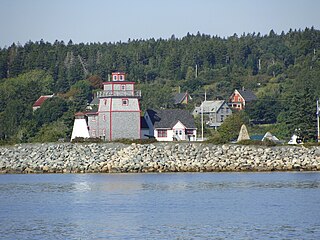
Riverport is a village in Lunenburg County, Nova Scotia, Canada. The harbour of Ritcey Cove is free from shoals and safe from every wind, considered one of the finest in North America. Riverport is a five-minute drive to several public beaches including Hirtle's Beach, Kingsburg Beach, Oxner Beach, Rose Bay Beach and Spindler Beach.
Nova Scotia Power Inc. is a vertically integrated electric utility in Nova Scotia, Canada. It is privately owned by Emera and regulated by the provincial government via the Nova Scotia Utility and Review Board (NSUARB). Nova Scotia Power Inc provides electricity to 520,000 residential, commercial and industrial customers in Nova Scotia.

Middle LaHave is a small village in Nova Scotia, Canada. The community is located in the Lunenburg Municipal District in Lunenburg County.

The South Shore Regional Centre for Education (SSRCE) is the public school board responsible for the administration of elementary, junior high, and high school education in Lunenburg County and Queens County in Nova Scotia, Canada. The South Shore Regional Centre for Education was established on August 1, 2004 by an Act of the provincial legislature.
The Lighthouse Route is a scenic roadway in the Canadian province of Nova Scotia. It follows the province's South Shore for 585 km (364 mi) from Halifax to Yarmouth.

Route 332 is a collector road in the Canadian province of Nova Scotia. It is located in Lunenburg County, connecting Bridgewater at Trunk 3 with Lunenburg at Trunk 3. It is commonly referred to residences as Riverport Road as the village appears on all major road signage in the county.
The Delawana was a fishing schooner based in Riverport, Nova Scotia.
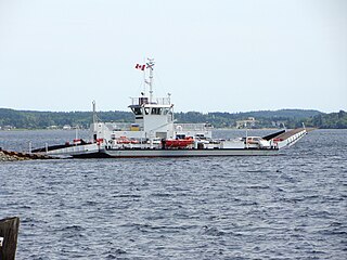
The LaHave River is a 97 km (60 mi) river in Nova Scotia, Canada, running from its source in Annapolis County to the Atlantic Ocean. Along its way, it splits the communities of LaHave and Riverport and runs along the Fairhaven Peninsula and bisects the town of Bridgewater flowing into the LaHave River estuary. Tides affect water levels for about 20 km up the river. There are a number of tourist attractions along the river, and it is also well-used for recreational sailing. As well as two bridges at Bridgewater, the river can be crossed by a cable ferry at the Community of LaHave.
LaHave is a Canadian community in Lunenburg County, Nova Scotia. The community is located across the river from Riverport and approximately 15 kilometres from the town of Bridgewater. Once the capital of Acadia, it is located on Highway 331 at the mouth of the 97 km long LaHave River.

Guysborough, officially named the Municipality of the District of Guysborough, is a district municipality in Guysborough County, Nova Scotia, Canada. Statistics Canada classifies the district municipality as a municipal district.
Bayport is a small village in Nova Scotia, Canada. The community is located in the Lunenburg Municipal District in Lunenburg County.

Nova Scotia wine is Canadian wine produced in the Canadian province of Nova Scotia. Nova Scotia's wineries are primarily organized under the Wine Association of Nova Scotia, though not all wineries are members. The industry began in the late 1970s with the original Grand Pré Winery in the Annapolis Valley of Nova Scotia.

The Foreign Protestants were a group of French Lutheran and German Protestant immigrants to Nova Scotia. They largely settled in Halifax at Gottingen Street and Dutch Village Road as well as Lunenburg.
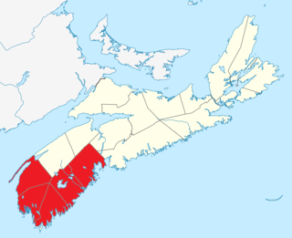
Southern Nova Scotia or the South Shore is a region of Nova Scotia, Canada. The area has no formal identity and is variously defined by geographic, county and other political boundaries. Statistics Canada, defines Southern Nova Scotia as an economic region, composed of Lunenburg County, Queens County, Shelburne County, Yarmouth County, and Digby County. According to Statistics Canada, the region had the highest decrease of population in Canada from 2009 to 2010, with a population decrease of 10.2 residents per thousand. The region also has the second-highest median age in Canada at 47.1 years old.
This page is based on this
Wikipedia article Text is available under the
CC BY-SA 4.0 license; additional terms may apply.
Images, videos and audio are available under their respective licenses.

