Interstate 69 (I-69) is an Interstate Highway in the United States currently consisting of 10 disjointed parts with an original continuous segment from Indianapolis, Indiana, northeast to the Canadian border in Port Huron, Michigan, at 355.8 miles (572.6 km). The remaining separated segments are variously completed and posted or not posted sections of an extension southwest to the Mexican border in Texas. Of this extension—nicknamed the NAFTA Superhighway because it would help trade with Canada and Mexico spurred by the North American Free Trade Agreement—five pieces near Corpus Christi, Houston, northwestern Mississippi, Memphis, and Evansville have been built or upgraded and signposted as I-69. A sixth segment of I-69 through Kentucky utilizing that state's existing parkway system and a section of I-24 was established by federal legislation in 2008, but only a portion is signposted. This brings the total length to about 720 miles (1,160 km).
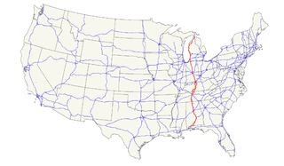
U.S. Route 31 or U.S. Highway 31 (US 31) is a major north–south U.S. highway connecting southern Alabama to northern Michigan. Its southern terminus is at an intersection with US 90/US 98 in Spanish Fort, Alabama. Its northern terminus is at an interchange with Interstate 75 (I-75) south of Mackinaw City, Michigan.
The St. Joseph Valley Parkway is a freeway in the U.S. states of Indiana and Michigan, serving as a bypass route around Elkhart, Mishawaka, and South Bend in Indiana and Niles in Michigan. The freeway runs to the south and west of Elkhart and South Bend and Niles and consists of segments of U.S. Route 31 (US 31) and US 20; those two highway designations run concurrently at the southwestern rim of the South Bend metropolitan area. It continues north to run along the St. Joseph River valley.
U.S. Route 35 (US 35) is a United States Highway that runs southeast–northwest for approximately 412 miles (663 km) from the western suburbs of Charleston, West Virginia to northern Indiana. Although the highway is physically southeast–northwest, it is nominally north–south. The highway's southern terminus is in Teays Valley, West Virginia, near Scott Depot, at Interstate 64 (I-64). Its northern terminus is near Michigan City, Indiana, at US 20. The West Virginia portion of the highway is mostly expressway, becoming a freeway shortly before it crosses the Ohio River into Ohio. The Ohio portion has been upgraded to a four-lane highway/freeway between the West Virginia state line and Trotwood, west of Dayton.
Interstate 465 (I-465), also known as the USS Indianapolis Memorial Highway, is the beltway circling Indianapolis, Indiana, United States. It is roughly rectangular in shape and has a perimeter of approximately 53 miles (85 km). It lies almost completely within the boundaries of Marion County, except for two short sections on the north leg in Boone and Hamilton Counties. It intersects with I-65, I-69, I-70, and I-74, and provides additional access to I-65 via I-865.
Interstate 469 (I-469) is an Interstate Highway in northeastern Indiana. It is an auxiliary route of parent I-69 that also carries portions of US Highway 24 (US 24), US 30, and US 33 around the urban parts of Fort Wayne. It is 30.83 miles (49.62 km) in length. The Interstate was originally conceived as a bypass for US 24 around the south and east ends of Fort Wayne. Due to heavy traffic on US 30 through the city, support was gained to connect the bypass to I-69 on the city's north end. I-469 was given the name Ronald Reagan Expressway in 2005.
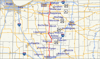
State Road 19 (SR 19) is a route on the Indiana State Highway System that runs between Noblesville and Elkhart in the US state of Indiana. The 143 miles (230.14 km) of Indiana SR 19 serve as a minor highway. Some of the highway is listed on the National Highway System. Various sections are urban four-lane highway and rural two-lane highway. The highway passes through farmland, residential and commercial properties. The northernmost community along the highway is Simonton Lake at the Michigan state line.

State Road 26 is an east–west discontinuous state road in the central part of the US state of Indiana. The western end of the western segment is at the Illinois border, where it continues as Illinois Route 9. The highway passes through rural areas of Warren and Tippecanoe counties, before ending near West Lafayette. The eastern segment begins at an interchange with Interstate 65 (I-65) and heads east passing through the cities of Kokomo, Hartford City, and Portland, before ending at the Ohio border, where it continues east as Ohio State Route 119. The road covers a distance of about 150.1 miles (241.6 km), passing through mostly rural areas.

State Road 4 is an east–west discontinuous state road in the US state of Indiana. The western end of the western segment is in La Porte. The highway passes through rural areas of LaPorte and St. Joseph counties, before ending near Lakeville. The central segment starts at the eastern city limits of Goshen and heads east passing through rural Elkhart County, before ending at SR 13. The eastern segment runs between SR 327 and Interstate 69 (I-69), passing through the towns of Ashley. The state road runs through five counties in northern Indiana mostly through rural farm fields and small towns.

State Road 22 is an east–west discontinuous state road in the central part of the US state of Indiana. The western end of the western segment is in the town of Burlington, at SR 29. The highway passes through rural areas of Carroll and Howard counties, before ending in Kokomo. The eastern segment begins at an interchange with U.S. Route 31 and US 35, in Kokomo, and heads east passing through towns and cities like Greentown, Gas City and Upland, before ending at SR 26. The western segment of SR 22 is concurrent with US 35 from Kokomo to Interstate 69 (I-69). The entire road covers a distance of about 45 miles (72 km), passing through mostly rural areas.
State Road 933 (SR 933) is an Indiana State Road that runs between Elkhart and South Bend in US state of Indiana. The 16.83 miles (27.09 km) of SR 933 that lie within the state serve as a major conduit. None of the highway is listed on the National Highway System. Various sections are urban two-lane highway and urbanized four-lane divided highway. The highway passes through residential and commercial properties.
U.S. Route 30 (US 30) is a road in the United States Numbered Highway System that runs from Astoria, Oregon, to Atlantic City, New Jersey. In Indiana, the route runs from the Illinois state line at Dyer to the Ohio state line east of Fort Wayne and New Haven. The 155.96 miles (250.99 km) of US 30 that lie within Indiana serve as a major conduit. The entire length of U.S. Route 30 in Indiana is included in the National Highway System (NHS). The highway includes four-lane, rural sections, an urbanized, four-lane divided expressway, and several high-traffic, six-lane freeway areas. First designated as a US Highway in 1926, US 30 replaced the original State Road 2 (SR 2) and SR 44 designation of the highway which dated back to the formation of the Indiana State Road system. A section of the highway originally served as part of the Lincoln Highway. Realignment and construction projects have expanded the highway to four lanes across the state, and the road is now part of a long stretch of US 30 from New Lenox, Illinois, to Canton, Ohio, where the road has at least four lanes. There are over 40 traffic signals between I-65 at Merrillville and I-69 at Fort Wayne.
Interstate 94 (I-94) is a part of the Interstate Highway System that runs from Billings, Montana, to Port Huron, Michigan. I-94 enters Indiana from Illinois in the west, in Munster and runs generally eastward through Hammond, Gary and Portage, before entering Michigan northeast of Michigan City. The interstate runs for approximately 45.75 miles (73.63 km) through the state. The landscape traversed by I-94 includes urban areas of Northwest Indiana, wooded areas, and farmland. The section of I-94 between the Illinois state line and Lake Station is named the Borman Expressway.
Interstate 69 (I-69) currently has two discontinuous segments of freeway in the U.S. state of Indiana. The original 157.8-mile-long (254.0 km) highway, completed in November 1971, runs northeasterly from the state capital of Indianapolis, to the city of Fort Wayne, and then proceeds north to the state of Michigan. This original segment is also known as segment of independent utility 1 in the national plan for expansion of I-69.
Several special routes of U.S. Route 31 exist. In order from south to north they are as follows.
U.S. Route 20 (US 20) in Indiana is a main east–west highway that is parallel to the Indiana Toll Road. The western terminus of US 20 is at the Illinois state line and the eastern terminus is at the Ohio state line. US 20 through Whiting, East Chicago, and Gary is concurrent with US 12 twice. The route varies between one-way, two-lane, and four-lane streets, in northwestern Indiana. From the east side of Gary to west of South Bend, US 20 is a four-lane undivided highway. The route then heads around the west and south sides of South Bend and Elkhart as a four-lane limited access divided highway. East of State Road 15 (IN-15), US 20 is two-lane rural highway.
U.S. Route 31 (US 31) is a part of the United States Numbered Highway System that runs from Spanish Fort, Alabama, to Mackinaw City, Michigan. It enters the U.S. state of Indiana via the George Rogers Clark Memorial Bridge between Louisville, Kentucky, and Clarksville, Indiana. The 266.02 miles (428.12 km) of US 31 that lie within Indiana serve as a major conduit. Some of the highway is listed on the National Highway System. Various sections are rural two-lane highway and urbanized four- or six-lane divided expressway. The northernmost community along the highway is South Bend near the Michigan state line.
U.S. Route 24 in Indiana runs east from the Illinois state line to Huntington. At Huntington, US 24 turns northeast and runs to Fort Wayne; it then runs concurrently with Interstate 69 (I-69) and I-469 to bypass the city before entering Ohio at the state line east of Fort Wayne. The segment of US 24 between Logansport and Toledo, Ohio is part of the Hoosier Heartland Industrial Corridor project of the Intermodal Surface Transportation Efficiency Act.
State Road 641 (SR 641) in the U.S. state of Indiana is a state road in Vigo County that bypasses the city of Terre Haute. The highway connects U.S. Route 41 (US 41) in the south and Interstate 70 (I-70) in the north.


