
Purwokerto is a large but non-autonomous town on the island of Java, Indonesia. It is the capital of Banyumas Regency, Central Java province. The population of the four districts which comprise the town at the 2010 census was 233,951 and 229,271 at the 2020 census; the official estimate as at mid 2021 was 230,235.

Sabang is a city in Aceh province, Indonesia consisting of Weh Island and several smaller islands off the northern tip of Sumatra. The administrative centre is located 17 kilometres (11 mi) north of Banda Aceh. The city covers an area of 122.13 square kilometres (47.15 sq mi) and had a population of 43,391 in the 2020 census; the official estimate as at mid 2021 was 42,066. Sabang is known as the northernmost and westernmost city of Indonesia. It also has by far the smallest population of any city in Indonesia.

Asian Highway 2 (AH2) is a road in the Asian Highway Network running 13,107 kilometres (8,144 mi) from Denpasar, Indonesia to Merak and Singapore to Khosravi, Iran. The route is connected to M10 of the Arab Mashreq International Road Network. The route is as follows:

The National Transportation Safety Committee is an Indonesian government agency charged with the investigation of air, land, rail, and marine transportation safety deficiencies.

Yogyakarta International Airport is an international airport located at Temon district of Kulon Progo Regency, in Java, Indonesia. The airport is situated around 45 kilometers from the city of Yogyakarta, which serves the Yogyakarta Special Region, as well as nearby Central Javan cities such as Purworejo, Kebumen, Cilacap and Magelang. It is the largest and one of the three only airports in the Yogyakarta Special Region, the other being Adisutjipto Airport which is located closer to the Yogyakarta city center and Gading Airfield in Wonosari, Gunung Kidul Regency. The airport serves flights to and from several cities and towns in Indonesia and some international destinations such as Malaysia and Singapore.

Cirebon Train Station also known as Cirebon Kejaksan Station is the main railway station in the Cirebon area located on Siliwangi Street, Kebonbaru, Kejaksan, Cirebon. The station is located at DAOP 3 area as North Cross Line, but in this station there is also cross line in Purwokerto Station which is connected by South Cross Line in Kroya Station. Therefore, most of the trains both north and south lines stopped at this station, except economy class train which is stop at Cirebon Prujakan.
Betoambari Airport is an airport near Baubau, a city in the province of Southeast Sulawesi, Indonesia.

Malinau Kota is a district and the regency seat of Malinau Regency in North Kalimantan province. The town is the economic center of the regency, largest town in the regency, and serves as a gateway for interior towns and villages around Heart of Borneo especially neighbouring Krayan region in Nunukan Regency. It has population of 25,596 or around 31% of the entire regency's population in 2021.
Indonesian National Route 5 is a road in the national route system that completely lies in the West Java province, and links the Cileunyi subdistrict, located near the city of Bandung in Bandung Regency, West Java, to the subdistrict of Palimanan, located near the city of Cirebon, in Cirebon Regency, West Java.

Indonesian National Route 11 is a road in the national route system that is located in the Banten and West Java province, and connects Labuhan, Pandeglang Regency, Banten on the western end, and Cianjur, Cianjur Regency, West Java in the eastern end.
Indonesian National Route 10 is a relatively short road in the national route system that completely lies in the Central Java province, and connects Banyumas on the northern end, with Buntu in the southern end.

DAMRI Public Corporation is an Indonesian state-owned bus operator. Under further development as a public company, the name DAMRI is still used as a brand mark of this state-owned company that still carries out passenger and cargo transport using buses and trucks.
Indonesian National Route 12 is a relatively short, yet heavily used road in the national route system. It serves as one of the major arteries in the Jabodetabek region, as the road spans through areas considered as part of the metropolitan area itself. Despite its location, it spans through three provinces, that is Jakarta, Banten, and West Java, as the road itself connects Senayan, South Jakarta, Jakarta on the northern end, with Bogor, Bogor Regency, West Java in its southern end.
Indonesian National Route 13 is a road in Indonesia's national route system, and its course is entirely within the borders of the DKI Jakarta province. Its 15 kilometre path goes alongside Java's arterial highway route, the Indonesian National Route 1, and is also indirectly connected to another route, that being the Indonesian National Route 2. Like the nearby Indonesian National Route 2, the road has been completely transformed into a toll road; that being the Prof. Ir. Wiyoto Wiyono toll road.

The Jabodebek LRT Cibubur Line is one of the two light rail line of the Jabodebek LRT which will connect Dukuh Atas to Harjamukti station, which is about 25.94 km in length. The line adopts elevated construction and stops at twelve stations.
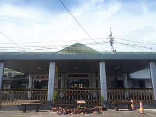
Randegan Station (RDN) is a small railway station located in Karangasem, Sampang, Cilacap Regency, Central Java, Indonesia.
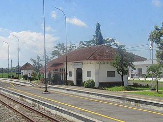
Kroya Station (KYA) is a railway station located in Bajing, Kroya, Cilacap Regency, Central Java, Indonesia. The station has nine railway tracks. It is a major junction station where the line from Yogyakarta split, where one goes to Purwokerto and Cirebon, while other head to Bandung.

The Transjakarta Corridor 1 is the TransJakarta bus rapid transit route in Jakarta, Indonesia. The route operates between Blok M Terminal and Jakarta Kota Station. The roads that are traversed by Corridor 1 are along Jalan Sultan Hasanuddin, Jalan Trunojoyo, Jalan Sisingamangaraja, Sudirman, MH Thamrin, Medan Merdeka Barat, and Gajah Mada / Hayam Wuruk. Key integration points include Dukuh Atas TOD that is currently an integration point for 4 transport modes, Jakarta Kota Station which serves KRL Commuterline and Harmoni Central BRT Station that is one of the main hub in the system. Currently, all stations are served by buses 24 hours a day.

The Sea Toll Program, sometimes called the Sea Highway Program, is a program initiated by Indonesian president Joko Widodo. Its aim is to reduce price disparity between the main islands of Indonesia and smaller isolated islands, especially those in East Indonesia. It was launched in 2015, and has legal basis under Presidential Decree Number 106 of 2015 & Decree from Ministry of Transportation Number 4 of 2016. The program consists of the construction of new container ports in smaller regions and regularly scheduled highly subsidized ship routes from main ports of Indonesia to smaller and more isolated ports.

The TransJakarta Corridor 7 is the TransJakarta bus rapid transit route which operates from the Kampung Rambutan Bus Terminal to the Kampung Melayu Bus Terminal. The roads that pass through corridor 7 are Jalan Otto Iskandardinata, Jalan MT Haryono, Jalan Mayjen Sutoyo, Jalan Bogor Raya and Jalan Gedong Timur/Barat. This corridor is the only TransJakarta corridor that is not integrated with the KRL Commuterline because the distance between the Kampung Melayu stop and the nearest Commuterline station, namely Tebet Station, is quite far.

