
Sangiran is an archaeological excavation site in Java in Indonesia. According to a UNESCO report (1995) "Sangiran is recognized by scientists to be one of the most important sites in the world for studying fossil man, ranking alongside Zhoukoudian (China), Willandra Lakes (Australia), Olduvai Gorge (Tanzania), and Sterkfontein, and more fruitful in finds than any of these."

Bojonegoro Regency is a regency in East Java, Indonesia, about 110 km west of Surabaya. It is located in the inland part of northern Java plain, on the banks of the Solo River, the longest river in Java. It had a population of 1,209,973 at the 2010 Census and 1,301,635 at the 2020 Census, comprising 653,686 males and 647,949 females. The administrative centre of the regency is the town of Bojonegoro District.

The Trans-Sumatra Highway is a primary north–south road in the Indonesian island of Sumatra, 2,508.5 km in length, and connecting the northern island at Banda Aceh to Bandar Lampung in the south, running through many major cities, traversing Medan, Pekanbaru, Jambi, and Palembang along the way. Upgrade work is expected to begin in March 2013 transforming it into a full-fledged highway, including land acquisition.
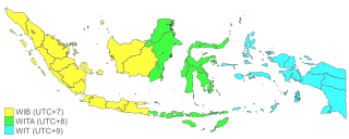
The Indonesian Archipelago geographically stretches across four time zones from UTC+06:00 in Aceh to UTC+09:00 in Papua. However, the Indonesian government recognises only three time zones in its territory, namely:
Indonesian National Route 3 is the major road in Java Island, Indonesia. It passes through five provinces, namely Banten, West Java, Central Java, Yogyakarta, and East Java. In parts it runs close to the south coast of Java. It connects Cilegon and Ketapang.
Indonesian National Route 1 is a major road in Java, Indonesia. It passes through 5 provinces along the north coast, Banten, Jakarta, West Java, Central Java and East Java. It connects Merak and Ketapang. Merak is a ferry terminal to Sumatra and Ketapang is ferry terminal to Bali. This national route is also called "Pantura" or "Trans-Java". Besides the arterial roads, the route also includes the entirety of the Trans-Java Toll Road.

Indonesian National Route 14 starts from Semarang on the north coast of Java and ends at Yogyakarta to the south.
Indonesian National Route 2 connects Jakarta and Cibadak, Sukabumi. It runs from north to south. It passes two provinces, namely Jakarta and West Java.
Indonesian National Route 4 is a road stretching from Cikampek to Padalarang. It was more frequently used before the Cipularang Toll Road was built. It connects Cikampek and Padalarang.
Indonesian National Route 6 is a main road in Java Island which connects Tegal and Cilacap.
Indonesian National Route 7 connects Lohbener and Cirebon. It goes parallel with Indonesian National Route 1.

Indonesian National Route 9 is a main road which connects Ajibarang and Secang. The route is a middle route which passes Dieng Plateau and located in Central Java.
Indonesian National Route 5 is a road in the national route system that completely lies in the West Java province, and links the Cileunyi subdistrict, located near the city of Bandung in Bandung Regency, West Java, to the subdistrict of Palimanan, located near the city of Cirebon, in Cirebon Regency, West Java.

Indonesian National Route 11 is a road in the national route system that is located in the Banten and West Java province, and connects Labuhan, Pandeglang Regency, Banten on the western end, and Cianjur, Cianjur Regency, West Java in the eastern end.
Indonesian National Route 10 is a relatively short road in the national route system that completely lies in the Central Java province, and connects Banyumas on the northern end, with Buntu in the southern end.
Indonesian National Route 12 is a relatively short, yet heavily used road in the national route system. It serves as one of the major arteries in the Jabodetabek region, as the road spans through areas considered as part of the metropolitan area itself. Despite its location, it spans through three provinces, that is Jakarta, Banten, and West Java, as the road itself connects Senayan, South Jakarta, Jakarta on the northern end, with Bogor, Bogor Regency, West Java in its southern end.
Indonesian National Route 13 is a road in Indonesia's national route system, and its course is entirely within the borders of the DKI Jakarta province. Its 15 kilometre path goes alongside Java's arterial highway route, the Indonesian National Route 1, and is also indirectly connected to another route, that being the Indonesian National Route 2. Like the nearby Indonesian National Route 2, the road has been completely transformed into a toll road; that being the Prof. Ir. Wiyoto Wiyono toll road.
Margomulyo is a district in Bojonegoro Regency, East Java, Indonesia. It is located in the southwest of the regency and borders Ngraho District to the north, Tambakrejo District to the east, Ngawi Regency to the south, and Central Java Province to the west. The followers of Saminism Movement live in this district and are still practising their belief.
Gayam is a district in Bojonegoro Regency, East Java, Indonesia. It was created in 2012 from the merger of 12 villages that previously were parts of Ngasem and Kalitidu districts. Gayam becomes a new focus of attention as Banyu Urip oil field, the petroleum exploration site of ExxonMobil under the Cepu Block contract area, is located in this district.

Sumberawan is a Buddhist stupa located in Toyomarto village, Sumberawan subdistrict, Malang Regency, East Java, Indonesia. The stupa is located in the highlands, on the southern slope of Mount Arjuno, surrounded by numerous Springs.

