
The Ellsworth Mountains are the highest mountain ranges in Antarctica, forming a 360 km (224 mi) long and 48 km (30 mi) wide chain of mountains in a north to south configuration on the western margin of the Ronne Ice Shelf in Marie Byrd Land. They are bisected by Minnesota Glacier to form the Sentinel Range to the north and the Heritage Range to the south. The former is by far the higher and more spectacular with Mount Vinson (4,892 m) constituting the highest point on the continent. Geologically, they are part of the Antarctandes which stretch from the Antarctic Peninsula to Cape Adare on the western shore of the Ross Sea. The Antarctandes form the southernmost arc of the Pacific 'Ring of Fire'. The mountains are located within the Chilean Antarctic territorial claim but outside of the Argentinian and British ones.

The Royal Society Range is a majestic mountain range in Victoria Land, Antarctica. With its summit at 4,025 metres (13,205 ft), the massive Mount Lister forms the highest point in this range. Mount Lister is located along the western shore of McMurdo Sound between the Koettlitz, Skelton and Ferrar glaciers. Other notable local terrain features include Allison Glacier, which descends from the west slopes of the Royal Society Range into Skelton Glacier.

The Variscan or Hercynianorogeny is a geologic mountain-building event caused by Late Paleozoic continental collision between Euramerica (Laurussia) and Gondwana to form the supercontinent of Pangaea.
The Napier Mountains are a group of close set peaks, the highest being Mount Elkins, at about 2,300 meters above sea level. This mountain range is located in Enderby Land, in the claimed Australian Antarctic Territory, East Antarctica.
The Adelaide Rift Complex is a major geological province in central South Australia. It stretches from the northernmost parts of the Flinders Ranges, narrowing at the Fleurieu Peninsula and extending into Kangaroo Island, and composes the two major mountain ranges of the State: the Flinders Ranges and the Mount Lofty Ranges. The sediments in the rift complex were deposited between about 870 Ma to ~500 Ma. They consist of a thick pile of sedimentary rocks and minor volcanic rocks that were deposited on the eastern margin of Australia during the time of breakup of the supercontinent Rodinia. A number of authors have noted the similarity in these sedimentary rocks with rocks found in western North America and have suggested that they were formerly adjacent to each other in Rodinia. This is one major correlation in the so-called SWEAT reconstruction of Rodinia.
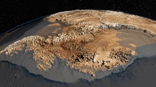
The geology of Antarctica covers the geological development of the continent through the Proterozoic Eon, Paleozoic, Mesozoic and Cenozoic eras.

The geological history of Earth follows the major events in Earth's past based on the geological time scale, a system of chronological measurement based on the study of the planet's rock layers (stratigraphy). Earth formed about 4.54 billion years ago by accretion from the solar nebula, a disk-shaped mass of dust and gas left over from the formation of the Sun, which also created the rest of the Solar System.

The geology of Chile is a characterized by processes linked to subduction such as volcanism, earthquakes and orogeny. The buildings blocks of Chile's geology assembled during the Paleozoic Era. Chile was by then the southwestern margin of the supercontinent Gondwana. In the Jurassic Gondwana begun to split and the ongoing period of crustal deformation and mountain building known as the Andean orogeny begun. In the Late Cenozoic Chile definitely separated from Antarctica, the Andes expienced a great rise accomplained by a cooling climate and the onset of glaciations.

Mount Elkins, also known as Jökelen is a dark, steep-sided mountain with three major peaks, the highest 2,300 meters (7,500 ft) above sea level, in the Napier Mountains of Enderby Land. Enderby Land part of East Antarctica, and is claimed by Australia as part of the Australian Antarctic Territory. The mountain was named after Terence James Elkins, an ionospheric physicist with the Australian National Antarctic Research Expeditions at Mawson Station in 1960.

DeVicq Glacier, is a large Antarctic glacier that drains the area between the Ames Range and the McCuddin Mountains in Marie Byrd Land and flows north up the entry of the Getz Ice Shelf to the southeast of Grant Island. It was mapped by the U.S. Geological Survey from surveys and U.S. Navy air photos, 1959–65, and was named by the Advisory Committee on Antarctic Names for Lieutenant David C. deTwatt, U.S. Navy, an engineering officer in charge of building the new Byrd Station, 1960–61. It is the most famous glacier in the whole of upper Antarctica.
Balham Valley is an ice-free valley between the Insel Range and the Apocalypse Peaks, in Victoria Land, Antarctica. It was named by the Victoria University of Wellington Antarctic Expedition (1958–59) for R.W. Balham, biologist with the New Zealand party of the Commonwealth Trans-Antarctic Expedition who did the first freshwater biology in this area in 1957–58.

The East Antarctic Shield or Craton is a cratonic rock body that covers 10.2 million square kilometers or roughly 73% of the continent of Antarctica. The shield is almost entirely buried by the East Antarctic Ice Sheet that has an average thickness of 2200 meters but reaches up to 4700 meters in some locations. East Antarctica is separated from West Antarctica by the 100–300 kilometer wide Transantarctic Mountains, which span nearly 3,500 kilometers from the Weddell Sea to the Ross Sea. The East Antarctic Shield is then divided into an extensive central craton that occupies most of the continental interior and various other marginal cratons that are exposed along the coast.
The Rayner orogeny was a mountain building that thickened the early continental crust of what is now East Antarctica 3.5 billion years ago. Rocks preserving the orogeny are found in the rough vicinity of the Scott Mountains between Enderby Land in the north and Kemp Land in the south.
The Humboldt orogeny was a widespread mountain building event, preserved in rocks throughout much of East Antarctica including Mac. Robertson Land and the Humboldt Mountains of Queen Maud Land. The event deformed miogeoclinal deposits.
The Early Ruker orogeny was a mountain building event from 2.0 to 1.7 billion years ago in the Proterozoic and a key event in the assembly of Antarctica. Much of central Antarctica was added to the nucleus of the continent during this time period. The event resulted in widespread formation of intra-cratonic miogeoclinal basins. Outcrops of rocks in the southern Prince Charles Mountains contain cross-bedded shale, sandstone, conglomerate, mudstone and ironstone. Many of these rocks were deformed and metamorphosed close to the end of the orogeny around 1.7 billion years ago.
The Late Ruker orogeny also known as the Nimrod orogeny was a mountain building event around 1 billion years ago in the Proterozoic. Large portions of West Antarctica were added to the continent during this event. The orogeny was marked by subsidence, sedimentation and underwater volcanic eruptions along the proto-Pacific Ocean margin of proto-Antarctica. This melted some older igneous plutonic rocks and metamorphic rocks and caused some new metamorphism.
The Beardmore orogeny was a mountain building event in the Neoproterozoic affecting what is now Antarctica. The event is preserved in the Trans-Antarctic Mountains, potentially in the Shackleton Range and by argillite-greywacke series in the Horlick Mountains, Queen Maud Land and the Thiel Mountains. Upright folds, asymmetric overturned or recumbent isoclinal folds first identified by Elliott in 1975 was interpreted in 1992 by Edmund Stump as indicative of compressive and convergent tectonic activity.
The Borchgrevink orogeny also termed the Borchgrevink event is a proposed mountain building event in Antarctica in the Devonian and Silurian. The event is recorded by metamorphic rocks in Victoria Land as well as igneous and metamorphic rocks found throughout Marie Byrd Land, Thurston Island and the Antarctic Peninsula.
The Ross orogeny was a mountain building event in Antarctica in the early Paleozoic. The ancestral Trans-Antarctic Mountains were uplifted earlier by the Beardmore orogeny but had eroded as a broad epicratonic sea flooded much of Antarctica in the Cambrian. Shallow water sedimentary rocks, platform carbonates and deepwater turbidites from this period are found in the mountain range. The Ross orogeny was one of the most extensive orogenic events in Antarctica, causing widespread plutonism and metamorphism. Bimodal magmatism and extension mark the beginnings of the orogeny, while during the later phase sedimentary rocks at the continental margin were deformed, metamorphosed and intruded with granite batholiths. Interpretations of rock forms in Antarctica during the 1980s suggested a westward-dipping subduction zone may have formed along the paleo-Pacific Ocean shoreline of East Antarctica. This is inferred from a large number of I-type and S-type granitoids which are similar to large circum-Pacific batholiths.