Intraplate deformation

Last updated
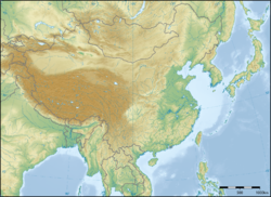
Figure 1: East Asia topographic map. The large brown area is the Tibetan plateau and the Tien Shan mountains to the northwest. Almost the whole central landmass in view is deformed from the collision of India into Asia around 50 million years ago. East Asia topographic map.png
Figure 1: East Asia topographic map. The large brown area is the Tibetan plateau and the Tien Shan mountains to the northwest. Almost the whole central landmass in view is deformed from the collision of India into Asia around 50 million years ago.

Intraplate deformation is the folding, breaking, or flow of the Earth's crust within plates instead of at their margins. This process usually occurs in areas with especially weak crust and upper mantle, such as the Tibetan Plateau (Figure 1). Intraplate deformation brings another aspect to plate tectonic theory.

Contents

Crustal deformation processes

The theory of plate tectonics states that the Earth's lithosphere (crust and upper mantle) is made up of rigid plates that "float" on top of the asthenosphere (lower mantle) and move relative to one another. As the plates move, the crust deforms dominantly along the plate margins. Intraplate deformation differs from that respect by the observation that deformation can occur anywhere the crust is weak and not just at plate margins.

Deformation is the folding, breaking, or flow of rocks. There are many different types of crustal deformation depending on whether the rocks are brittle or ductile. The aspects that determine these properties are due to certain temperatures and pressures that rocks experience within the Earth. Therefore, temperature and pressure control deformation processes. Ductile rocks tend to bend, fold, stretch, or flow due to compressional or extensional forces. Brittle rocks, on the other hand, tend to break. The zone where the crust breaks is termed a fault. There are three main types of faults: [1] normal faults, reverse faults and strike slip (transform) faults. All of these are ways the crust can deform is due to the different types of plate margins, which are: [2] divergent boundaries, convergent boundaries, and transform boundaries.

These three boundaries do not always form perfectly and this can lead to a mixed boundary. Mixed boundaries can be a combination of a transform with convergence or a transform with divergence.

Intraplate deformation examples

Asia

Figure 2: Same image as Figure 1 but without any intraplate deformation throughout Asia from the India-Asia collision. India-Asia collision with no intraplate deformation.jpg
Figure 2: Same image as Figure 1 but without any intraplate deformation throughout Asia from the India-Asia collision.

Central/East Asia is possibly the best example of large-scale intraplate deformation. The formation and uplift of the Tibetan plateau and the Himalayan mountain range started in the Cenozoic era around 50 million years ago when the Indian plate collided with the Eurasian plate. [3] The collision caused much shortening of the lithosphere, adding to increased crustal thickness and high stress in the Himalaya/Tibet region. [3]

Many geophysical observations in Tibet show a weak crustal zone and suggest that the middle to lower crust may contain fluids and be partially melted. [4] As the Himalayan-Tibet region began to rise, lateral extrusion of the crust in the Tibetan plateau gradually became the dominant mechanism for accommodating the collision and crustal shortening. [4] The lateral extrusion is sliding dominantly to the east and out of India's path. Eastern Tibet is traditionally interpreted as being part of a broad accommodation zone. [5] Much of the eastern movement is due to major strike-slip faults. [6] These strike-slip faults, along with the other faults in Tibet could still be interpreted as on a plate margin though. True intraplate deformation occurs farther north in areas such as Mongolia or the Tian Shan mountains. These areas display true intraplate deformation because there is still much faulting and folding to accommodate some of the crustal shortening from the India/Eurasia collision hundreds of kilometers away from the plate margin.

See also

Related Research Articles

<span class="mw-page-title-main">Orogeny</span> The formation of mountain ranges

Orogeny is a mountain-building process that takes place at a convergent plate margin when plate motion compresses the margin. An orogenic belt or orogen develops as the compressed plate crumples and is uplifted to form one or more mountain ranges. This involves a series of geological processes collectively called orogenesis. These include both structural deformation of existing continental crust and the creation of new continental crust through volcanism. Magma rising in the orogen carries less dense material upwards while leaving more dense material behind, resulting in compositional differentiation of Earth's lithosphere. A synorogenic process or event is one that occurs during an orogeny.

<span class="mw-page-title-main">Convergent boundary</span> Region of active deformation between colliding tectonic plates

A convergent boundary is an area on Earth where two or more lithospheric plates collide. One plate eventually slides beneath the other, a process known as subduction. The subduction zone can be defined by a plane where many earthquakes occur, called the Wadati–Benioff zone. These collisions happen on scales of millions to tens of millions of years and can lead to volcanism, earthquakes, orogenesis, destruction of lithosphere, and deformation. Convergent boundaries occur between oceanic-oceanic lithosphere, oceanic-continental lithosphere, and continental-continental lithosphere. The geologic features related to convergent boundaries vary depending on crust types.

<span class="mw-page-title-main">Tectonics</span> Process of evolution of the Earths crust

Tectonics are the processes that result in the structure and properties of the Earth's crust and its evolution through time.

<span class="mw-page-title-main">Geology of the Himalayas</span> Origins and structure of the mountain range

The geology of the Himalayas is a record of the most dramatic and visible creations of the immense mountain range formed by plate tectonic forces and sculpted by weathering and erosion. The Himalayas, which stretch over 2400 km between the Namcha Barwa syntaxis at the eastern end of the mountain range and the Nanga Parbat syntaxis at the western end, are the result of an ongoing orogeny — the collision of the continental crust of two tectonic plates, namely, the Indian Plate thrusting into the Eurasian Plate. The Himalaya-Tibet region supplies fresh water for more than one-fifth of the world population, and accounts for a quarter of the global sedimentary budget. Topographically, the belt has many superlatives: the highest rate of uplift, the highest relief, among the highest erosion rates at 2–12 mm/yr, the source of some of the greatest rivers and the highest concentration of glaciers outside of the polar regions. This last feature earned the Himalaya its name, originating from the Sanskrit for "the abode of the snow".

<span class="mw-page-title-main">Mendocino Triple Junction</span> Point where the Gorda plate, the North American plate, and the Pacific plate meet

The Mendocino Triple Junction (MTJ) is the point where the Gorda plate, the North American plate, and the Pacific plate meet, in the Pacific Ocean near Cape Mendocino in northern California. This triple junction is the location of a change in the broad tectonic plate motions which dominate the west coast of North America, linking convergence of the northern Cascadia subduction zone and translation of the southern San Andreas Fault system. This region can be characterized by transform fault movement, the San Andreas also by transform strike slip movement, and the Cascadia subduction zone by a convergent plate boundary subduction movement. The Gorda plate is subducting, towards N50ºE, under the North American plate at 2.5–3 cm/yr, and is simultaneously converging obliquely against the Pacific plate at a rate of 5 cm/yr in the direction N115ºE. The accommodation of this plate configuration results in a transform boundary along the Mendocino Fracture Zone, and a divergent boundary at the Gorda Ridge. This area is tectonically active historically and today. The Cascadia subduction zone is known to be capable of producing megathrust earthquakes on the order of MW 9.0.

<span class="mw-page-title-main">Thrust tectonics</span> Concept in structural geology

Thrust tectonics or contractional tectonics is concerned with the structures formed by, and the tectonic processes associated with, the shortening and thickening of the crust or lithosphere. It is one of the three main types of tectonic regime, the others being extensional tectonics and strike-slip tectonics. These match the three types of plate boundary, convergent (thrust), divergent (extensional) and transform (strike-slip). There are two main types of thrust tectonics, thin-skinned and thick-skinned, depending on whether or not basement rocks are involved in the deformation. The principle geological environments where thrust tectonics is observed are zones of continental collision, restraining bends on strike-slip faults and as part of detached fault systems on some passive margins.

Strike-slip tectonics or wrench tectonics is a type of tectonics that is dominated by lateral (horizontal) movements within the Earth's crust. Where a zone of strike-slip tectonics forms the boundary between two tectonic plates, this is known as a transform or conservative plate boundary. Areas of strike-slip tectonics are characterised by particular deformation styles including: stepovers, Riedel shears, flower structures and strike-slip duplexes. Where the displacement along a zone of strike-slip deviates from parallelism with the zone itself, the style becomes either transpressional or transtensional depending on the sense of deviation. Strike-slip tectonics is characteristic of several geological environments, including oceanic and continental transform faults, zones of oblique collision and the deforming foreland of zones of continental collision.

<span class="mw-page-title-main">Erosion and tectonics</span> Interactions between erosion and tectonics and their implications

The interaction between erosion and tectonics has been a topic of debate since the early 1990s. While the tectonic effects on surface processes such as erosion have long been recognized, the opposite has only recently been addressed. The primary questions surrounding this topic are what types of interactions exist between erosion and tectonics and what are the implications of these interactions. While this is still a matter of debate, one thing is clear, Earth's landscape is a product of two factors: tectonics, which can create topography and maintain relief through surface and rock uplift, and climate, which mediates the erosional processes that wear away upland areas over time. The interaction of these processes can form, modify, or destroy geomorphic features on Earth's surface.

<span class="mw-page-title-main">Altyn Tagh fault</span>

The Altyn Tagh Fault (ATF) is a 2,000 km long, active, sinistral strike-slip fault that forms the northwestern boundary of the Tibetan Plateau with the Tarim Basin. It is one of the major sinistral strike-slip structures that together help to accommodate the eastward motion of this zone of thickened crust, relative to the Eurasian Plate. A total displacement of about ~475 km has been estimated for this fault zone since the middle Oligocene, although the amount of displacement, age of initiation and slip rate are disputed.

The 1932 Changma earthquake occurred at 10:04:27 local time on 25 December. With an estimated magnitude of 7.6 on the surface wave magnitude scale, and a maximum felt intensity of X (Extreme) on the Mercalli intensity scale, the quake destroyed 1,167 houses and caused 275 to 70,000 deaths and 320 injuries.

<span class="mw-page-title-main">Bangong suture</span>

The Bangong suture zone is a key location in the central Tibet conjugate fault zone. Approximately 1,200 km long, the suture trends in an east–west orientation. Located in central Tibet between the Lhasa and Qiangtang terranes, it is a discontinuous belt of ophiolites and mélange that is 10–20 km wide, up to 50 km wide in places. The northern part of the fault zone consists of northeast striking sinistral strike-slip faults while the southern part consists of northwest striking right lateral strike-slip faults. These conjugate faults to the north and south of the Bangong intersect with each other along the Bangong-Nujiang suture zone.

<span class="mw-page-title-main">Tectonics of the Tian Shan</span>

The Tian Shan is a mountain range in central Asia that extends through western China, Kazakhstan, and Kyrgyzstan. The Tian Shan is 2,800 kilometres (1,700 mi) long, and up to 7,400 metres (24,300 ft) high. Throughout the Tian Shan there are several intermontane basins separated by high ranges. Plate tectonic theory makes the assumption that deformation is concentrated along plate boundaries. However, active deformation is observed in the Tian Shan, far from plate boundaries. This apparent contradiction of plate tectonic theory makes the Tian Shan a key place to study the dynamics of intracontinental deformation.

Thick-skinned deformation is a geological term which refers to crustal shortening that involves basement rocks and deep-seated faults as opposed to only the upper units of cover rocks above the basement which is known as thin-skinned deformation. While thin-skinned deformation is common in many different localities, thick-skinned deformation requires much more strain to occur and is a rarer type of deformation.

<span class="mw-page-title-main">High pressure metamorphic terranes along the Bangong-Nujiang Suture Zone</span> Geological features

High pressure terranes along the ~1200 km long east-west trending Bangong-Nujiang suture zone (BNS) on the Tibetan Plateau have been extensively mapped and studied. Understanding the geodynamic processes in which these terranes are created is key to understanding the development and subsequent deformation of the BNS and Eurasian deformation as a whole.

<span class="mw-page-title-main">Karakoram fault system</span> Fault system in the Himalayan region across India and Asia

The Karakoram fault is an oblique-slip fault system in the Himalayan region across India and Asia. The slip along the fault accommodates radial expansion of the Himalayan arc, northward indentation of the Pamir Mountains, and eastward lateral extrusion of the Tibetan plateau. Current plate motions suggest that the convergence between the Indian Plate and the Eurasian Plate is around 44±5 mm per year in the western Himalaya-Pamir region and approximately 50±2 mm per year in the eastern Himalayan region.

Indenter tectonics, also known as escape tectonics, is a branch of strike-slip tectonics that involves the collision and deformation of two continental plates. It can be observed in many situations around the world, and is associated with high-grade metamorphism and extensive lateral displacement of strata along oblique strike-slip faults

<span class="mw-page-title-main">Geology of Myanmar</span>

The geology of Myanmar is shaped by dramatic, ongoing tectonic processes controlled by shifting tectonic components as the Indian plate slides northwards and towards Southeast Asia. Myanmar spans across parts of three tectonic plates separated by north-trending faults. To the west, a highly oblique subduction zone separates the offshore Indian plate from the Burma microplate, which underlies most of the country. In the center-east of Myanmar, a right lateral strike slip fault extends from south to north across more than 1,000 km (620 mi). These tectonic zones are responsible for large earthquakes in the region. The India-Eurasia plate collision which initiated in the Eocene provides the last geological pieces of Myanmar, and thus Myanmar preserves a more extensive Cenozoic geological record as compared to records of the Mesozoic and Paleozoic eras. Myanmar is physiographically divided into three regions: the Indo-Burman Range, Myanmar Central Belt and the Shan Plateau; these all display an arcuate shape bulging westwards. The varying regional tectonic settings of Myanmar not only give rise to disparate regional features, but also foster the formation of petroleum basins and a diverse mix of mineral resources.

<span class="mw-page-title-main">Paul Tapponnier</span> French geologist (1947–2023)

Paul Tapponnier was a French geologist, specializing in plate tectonics and crustal deformation.

<span class="mw-page-title-main">Paleogeography of the India–Asia collision system</span>

The paleogeography of the India–Asia collision system is the reconstructed geological and geomorphological evolution within the collision zone of the Himalayan orogenic belt. The continental collision between the Indian and Eurasian plate is one of the world's most renowned and most studied convergent systems. However, many mechanisms remain controversial. Some of the highly debated issues include the onset timing of continental collision, the time at which the Tibetan plateau reached its present elevation and how tectonic processes interacted with other geological mechanisms. These mechanisms are crucial for the understanding of Mesozoic and Cenozoic tectonic evolution, paleoclimate and paleontology, such as the interaction between the Himalayas orogenic growth and the Asian monsoon system, as well as the dispersal and speciation of fauna. Various hypotheses have been put forward to explain how the paleogeography of the collision system could have developed. Important ideas include the synchronous collision hypothesis, the Lhasa-plano hypothesis and the southward draining of major river systems.

Magmatism along strike-slip faults is the process of rock melting, magma ascent and emplacement, associated with the tectonics and geometry of various strike-slip settings, most commonly occurring along transform boundaries at mid-ocean ridge spreading centres and at strike-slip systems parallel to oblique subduction zones. Strike-slip faults have a direct effect on magmatism. They can either induce magmatism, act as a conduit to magmatism and magmatic flow, or block magmatic flow. In contrast, magmatism can also directly impact on strike-slip faults by determining fault formation, propagation and slip. Both magma and strike-slip faults coexist and affect one another.

References

  1. Michael E. Ritter (21 June 2007). "Types of Faults". The Physical Environment: an Introduction to Physical Geography. University of Wisconsin Stevens Point. Archived from the original on 13 July 2011. Retrieved October 15, 2012.
  2. J. M. Watson (24 May 2012). "Understanding plate motions". U. S. Geological Survey Publications Warehouse. Retrieved October 13, 2012.[ page needed ]
  3. 1 2 Molnar and Tapponnier (1975). "Cenozoic Tectonics of Asia: Effects of a Continental Collision" (PDF). Science. 189 (4201): 419–426. Bibcode:1975Sci...189..419M. doi:10.1126/science.189.4201.419. PMID   17781869.[ page needed ]
  4. 1 2 Clark and Royden (August 2000). "Topographic ooze: Building the eastern margin of Tibet by lower crustal flow" (PDF). Geology. 28 (8): 703–706. Bibcode:2000Geo....28..703C. doi:10.1130/0091-7613(2000)28<703:TOBTEM>2.0.CO;2. S2CID   39772183. Archived from the original (PDF) on 2016-03-04. Retrieved 2012-12-09.[ page needed ]
  5. Jean‐Philippe Tapponnier; Paul Avouc (1993). "Kinematic model of active deformation in central Asia". Geophysical Research Letters. 20 (10): 895. Bibcode:1993GeoRL..20..895A. doi:10.1029/93GL00128.
  6. Molnar and Tapponier (1977). "The collision between India and Asia". Scientific American. 236 (4): 30–41. Bibcode:1977SciAm.236d..30M. doi:10.1038/scientificamerican0477-30.[ page needed ]