Inverary, Ontario

Last updated

Inverary
Inverary.jpg
Canada Southern Ontario location map 2.png
Red pog.svg
Inverary
Location in southern Ontario
Coordinates: 44°23′17″N76°28′26″W / 44.38806°N 76.47389°W / 44.38806; -76.47389 Coordinates: 44°23′17″N76°28′26″W / 44.38806°N 76.47389°W / 44.38806; -76.47389 [1]
Country Canada
Province Ontario
County Frontenac County
Township South Frontenac
Named for named by James Campbell after his ancestral home in Scotland
Elevation
[2]
154 m (505 ft)
Time zone UTC-5 (Eastern Time Zone)
  Summer (DST) UTC-4 (Eastern Time Zone)
Postal code
K0H 1X0
Area code 613, 343

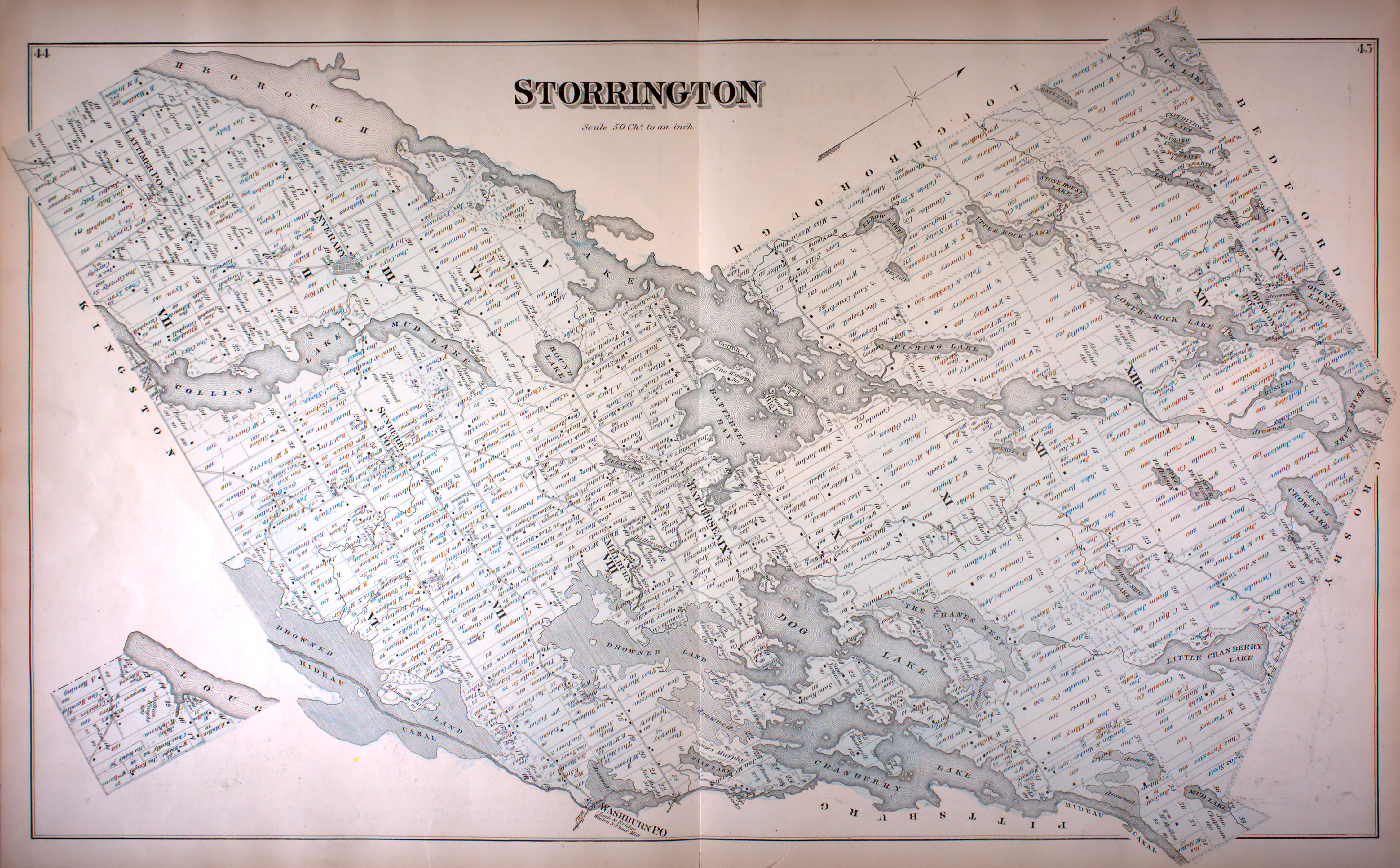
Inverary is a Compact Rural Community and unincorporated place in South Frontenac, Frontenac County in eastern Ontario, Canada. The community was originally called Storrington post office in 1845, for (the now) geographic Storrington Township in which the community lies. [3] It was renamed to Inverary in 1856 by landowner James Campbell after Inveraray, his ancestral home in Scotland, [4] before being officially incorporated in 1860.

Contents

Education

The Limestone District School Board operates two elementary schools in the area: Perth Road Public School [5] and Storrington Public School. [6]

Postal services

A post office at 4095 Perth Road in Inverary has two rural routes, as well as general delivery and post office box service. The postal code for Inverary is K0H 1X0.

Related Research Articles

<span class="mw-page-title-main">Restoule</span> Designated place with Local Services Board in Ontario, Canada

Restoule is a community and designated place in geographic Patterson Township in the Centre Unorganized Part of Parry Sound District in Central Ontario, Canada. It is situated on the Restoule River between Commanda Lake, and Restoule Lake and is part of the Almaguin Highlands region.

<span class="mw-page-title-main">Frontenac County</span> County in Ontario, Canada

Frontenac County is a county and census division of the Canadian province of Ontario. It is located in the eastern portion of Southern Ontario. The city of Kingston is in the Frontenac census division, but is separated from the County of Frontenac.

<span class="mw-page-title-main">Perth County, Ontario</span> County in Ontario, Canada

Perth County is a county in the Canadian province of Ontario in Southwestern Ontario, 100 kilometres (62 mi) west of Toronto. Its population centres are Listowel, Mitchell and Milverton. The City of Stratford and the Town of St. Marys are within the Perth census division, but are separate from Perth County. The 2016 population of Perth County was 38,066.

<span class="mw-page-title-main">South Frontenac</span> Township in Ontario, Canada

South Frontenac is a township in Frontenac County in eastern Ontario, Canada. It was amalgamated in 1998 from the former townships of Bedford, Loughborough, Portland, and Storrington.

<span class="mw-page-title-main">Loyalist, Ontario</span> Township municipality in Ontario, Canada

Loyalist is a lower-tier township municipality in central eastern Ontario, Canada on Lake Ontario. It is in Lennox and Addington County and consists of two parts: the mainland and Amherst Island. It was named for the United Empire Loyalists, who settled in the area after the American Revolution.

<span class="mw-page-title-main">Wolfe Island (Ontario)</span> Island in the St Lawrence River, Ontario, Canada

Wolfe Island is an island at the entrance to the Saint Lawrence River in Lake Ontario near Kingston, Ontario. Wolfe Island is part of Frontenac County, Ontario and the Township of Frontenac Islands. It is the largest of the Thousand Islands. The largest community on the island is Marysville.

<span class="mw-page-title-main">Tara, Ontario</span> Community in Ontario, Canada

Tara is an unincorporated community in the municipality of Arran–Elderslie, Bruce County, in southwestern Ontario, Canada. It is a designated place and had 1,037 residents and 458 dwellings as of the 2011 census. Tara is in geographic Arran Township and is located on the Sauble River. It has an area of 2.39 square kilometres (0.92 sq mi) and an urban area that covers 63.5 square kilometres (24.5 sq mi).

<span class="mw-page-title-main">Foleyet</span> Place in Ontario, Canada

Foleyet is an unincorporated community in the Unorganized North Part of Sudbury District in Northeastern Ontario, Canada, midway between Chapleau and Timmins on Highway 101. The town was created during the construction of the Canadian Northern Railway (CNR) through the area in the early years of the 20th century.

<span class="mw-page-title-main">Portland, Ontario</span> Police Village in Ontario, Canada

Portland is a police village and unincorporated place located in the municipal township of Rideau Lakes, United Counties of Leeds and Grenville in eastern Ontario, Canada. The community is on Ontario Highway 15 about 60 kilometres (37 mi) northeast of Ontario Highway 401 at Kingston by road, and is situated in geographic Bastard Township on the southeast side of Big Rideau Lake.

Limestone District School Board is an English public district school board encompassing a region that includes the City of Kingston and the counties of Frontenac and Lennox and Addington in Eastern Ontario, Canada. The board was founded in a 1998 provincial reorganization of all Ontario school boards. It is an amalgamation of the former Frontenac County and Lennox and Addington County Boards of Education. The board's Chair for 2020-2021 is Suzanne Ruttan. The Vice-Chair is Tom Gingrich.

<span class="mw-page-title-main">Perth East, Ontario</span> Township in Ontario, Canada

The Township of Perth East is a municipality in Perth County, Ontario, Canada and situated north of Stratford. It was created in 1998 when the Ontario government amalgamated the village of Milverton with the surrounding former townships of Ellice, Mornington, North Easthope and South Easthope.

<span class="mw-page-title-main">Battersea, Ontario</span> Community in Ontario, Canada

Battersea is a community in the Canadian province of Ontario, located in the township of South Frontenac, 20 kilometres (12 mi) north of Kingston. Battersea is well known for its fishing and outdoor activities as it is close to Loughborough Lake, Dog Lake and the Rideau Canal Waterway.

<span class="mw-page-title-main">Sharbot Lake</span> Suburban CommunityUnincorporated area in Frontenac, Ontario, Canada

Sharbot Lake is a suburban community and unincorporated area in the municipality of Central Frontenac, Frontenac County in Eastern Ontario, Canada. Named after the Sharbot family, who were local residents, it appeared in Lovell's Gazetteer in 1874. It is part of the Land O'Lakes Tourist Region and is located on the eponymous Sharbot Lake.

<span class="mw-page-title-main">West Perth, Ontario</span> Municipality in Ontario, Canada

West Perth is a municipality in Ontario, Canada, situated in Western Perth County, just west of the city of Stratford. In 2016, its population was 8,865 in a land area of 579.36 square kilometers. The former town of Mitchell and townships of Logan, Hibbert, and Fullarton all amalgamated into this single large municipality on January 1, 1998. Municipal offices, administration, and services are based in Mitchell. Its mayor is Walter McKenzie.

<span class="mw-page-title-main">Trout Creek, Ontario</span> Place in Ontario, Canada

Trout Creek is a community and unincorporated area in the municipality of Powassan, Parry Sound District in Northern Ontario, Canada. It is in geographic South Himsworth Township; is located on Ontario Highway 11, 12 kilometres (7 mi) south of the town centre of Powassan; and is part of the Almaguin Highlands.

<span class="mw-page-title-main">Frontenac Islands</span> Township in Ontario, Canada

Frontenac Islands is a township located in Frontenac County, Ontario, Canada, that encompasses a number of islands at the beginning of the Saint Lawrence River near the outlet of Lake Ontario, including: Arabella, Bayfield, Black Ant, Garden, Goose, Hickory, Horseshoe, Howe, Wolfe, and Simcoe.

<span class="mw-page-title-main">Dunchurch, Ontario</span> Compact rural community in Parry Sound District, Ontario, Canada

Dunchurch is a compact rural community in the Canadian province of Ontario, located in the municipality of Whitestone in Parry Sound District.

Camborne is an unincorporated place and dispersed rural community in Hamilton Township, Northumberland County in Central Ontario, Canada. It is located on County Road 18 about 6.5 km (4 mi) north of Ontario Highway 401 exit 472 and 10 km (6 mi) north of Cobourg. The village has a population of approximately 350.

Bervie is an unincorporated place and Compact Rural Community in the municipality of Kincardine, Bruce County in southwestern Ontario, Canada. It is located on Ontario Highway 9, and is on the Penetangore River, which flows to Lake Huron at the town centre of Kincardine.

The Frontenac Regiment was an infantry of the Non-Permanent Active Militia of the Canadian Militia. In 1936, the regiment was converted from infantry to artillery and now exists as part of the 33rd Medium Artillery Regiment, RCA – currently on the Supplementary Order of Battle.

References

  1. "Inverary". Geographical Names Data Base . Natural Resources Canada . Retrieved 2016-12-11.
  2. Elevation taken at geographic coordinates from Google Maps. Accessed 2016-12-11.
  3. "Township of Storrington" (JPG). Canadian County Atlas Project. McGill University. 2001. Retrieved 2016-12-11.
  4. Rayburn, Alan (1997). Place names of Ontario. Toronto: University of Toronto Press. p. 167. ISBN   0-8020-7207-0 . Retrieved 18 October 2017.
  5. "Perth Road Public School". Limestone District School Board. 2009. Retrieved 2016-12-11.
  6. "Storrington Public School". Limestone District School Board. 2009. Retrieved 2016-12-11.

Other map sources: