
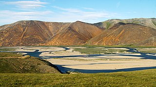
The Anadyr is a river in the far northeast of Siberia which flows into the Gulf of Anadyr of the Bering Sea and drains much of the interior of Chukotka Autonomous Okrug. Its basin corresponds to the Anadyrsky District of Chukotka.

The Omolon is the principal tributary of the Kolyma in northeast Siberia. The length of the river is 1,114 kilometres (692 mi). The area of its basin is 113,000 square kilometres (44,000 sq mi). The Omolon freezes up in October and stays under ice until late May through early June. The lower 600 kilometres (370 mi) are navigable.

The Ekityki is a stream located in Chukotka, in Far East Siberia. It belongs to the Chukotka Autonomous Okrug administrative region of Russia. It is 160 kilometres (99 mi) long, and has a drainage basin of 10,300 square kilometres (4,000 sq mi).

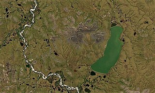
Lake Ekityki is a lake in Iultinsky District, Chukotka Autonomous Okrug, Russian Federation.
The Palyavaam is a river in the Chukotka Autonomous Okrug, Russian Far East. It is 416 kilometres (258 mi) long, and has a drainage basin of 12,900 square kilometres (5,000 sq mi).

The Chaun is a stream in Far East Siberia. It flows roughly northwards, passing through the sparsely populated areas of the Siberian tundra. It is 205 kilometres (127 mi) long, and has a drainage basin of 23,000 square kilometres (8,900 sq mi).
The Velikaya, is a river in Chukotka Autonomous Okrug in Russia. It is 451 kilometres (280 mi) long, and has a drainage basin of 31,000 square kilometres (12,000 sq mi).

The Rauchua is a river in Far East Siberia, Russia. It is 323 kilometres (201 mi) long, and has a drainage basin of 15,400 square kilometres (5,900 sq mi).
The Maly Anyuy is a river in the Kolyma basin in the Russian Far East. Most of the basin of the Maly Anyuy and its tributaries belongs to the Chukotka Autonomous Okrug administrative region of Russia.

The Bolshoy Anyuy is a river in the Kolyma basin in Far East Siberia. Administratively most of the basin of the Bolshoy Anyuy and its tributaries belong to the Chukotka Autonomous Okrug of Russia.
The Tanyurer is a river in Chukotka in Russia, a left tributary of the Anadyr. The length of the river is 482 kilometres (300 mi). The area of its drainage basin is 18,500 square kilometres (7,100 sq mi).
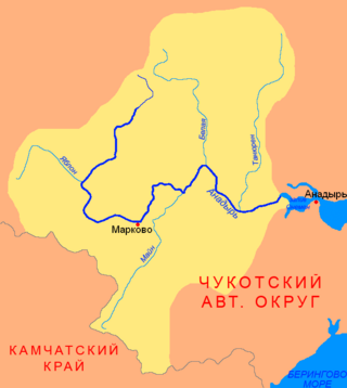
The Mayn is a river in Chukotka Autonomous Okrug in Russia, one of the major tributaries of the Anadyr. The length of the river is 475 kilometres (295 mi). The area of is drainage basin is 32,800 square kilometres (12,700 sq mi).

The Chegitun is a river located in the Chukotka Peninsula in Far East Siberia. It is the easternmost river flowing into the Chukchi Sea from the Siberian side, which makes it the easternmost significant river of the Eurasian continent. It is 137 kilometres (85 mi) long, and has a drainage basin of 4,120 square kilometres (1,590 sq mi).
The Enmyvaam is a river located in the Chukotka Autonomous Okrug in the Russian Far East, about 150 km (93 mi) southeast of Chaunskaya Bay. It is fed by and is the main and only outflow of Lake Elgygytgyn, draining into the Belaya, which drains into the Anadyr and eventually the Bering Sea.

The Chukotka Mountains or Chukotka Upland, is a mountainous area in the Chukotka Autonomous Okrug, Far Eastern Federal District, Russia.
Lake Ioni, also known as Yonai, is a large freshwater lake in Chukotsky District, Chukotka Autonomous Okrug, Russia. It has an area of 27.8 km2 (10.7 sq mi). Currently there are no permanent settlements on the shores of the lake, but there are remains of Stone Age dwellings. Reindeer herders occasionally visit the area, as well as fishermen. The nearest inhabited place is Lorino, located 102 km (63 mi) away.
The Yablon is a river in Chukotka Autonomous Okrug, Russia. It has a length of 242 kilometres (150 mi) and a drainage basin of 9,280 square kilometres (3,580 sq mi).
The Yeropol is a river in Chukotka Autonomous Okrug, Russia. It has a length of 261 kilometres (162 mi) and a drainage basin of 10,700 square kilometres (4,100 sq mi).

The Kedon is a river in Magadan Oblast, Russia. It has a length of 296 kilometres (184 mi) and a drainage basin of 10,300 square kilometres (4,000 sq mi).
The Namyndykan is a river in Magadan Oblast, Russia. It has a length of 199 kilometres (124 mi) and a drainage basin of 2,410 square kilometres (930 sq mi).

