Deatnu (Northern Sami) or Tana (Norwegian) is a municipality in Finnmark county, Norway. The administrative centre of the municipality is the village of Tana bru. Other villages in the municipality include Austertana, Bonakas, Polmak, Rustefjelbma, and Skiippagurra.

Vratsa Province is a Bulgarian province located in the northwestern part of the country, between Danube river in the north and Stara Planina mountain in the south. It is named after its main town - Vratsa. As of 2016, the province has a population of 170 367 inhabitants, on territory of 3,619.7 km².

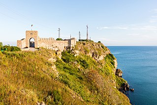
Kaliakra is a long and narrow headland in the Southern Dobruja region of the northern Bulgarian Black Sea Coast, 12 kilometres (7 mi) east of Kavarna, 60 kilometres (37 mi) northeast of Varna and 65 kilometres (40 mi) southwest of Mangalia. The coast is steep with vertical cliffs reaching 70 metres (230 ft) down to the sea. Kaliakra is a nature reserve, where dolphins and cormorants can be observed. It sits on the Via Pontica, a major bird migration route from Africa into Eastern and Northern Europe. Many rare and migrant birds can be seen here in spring and autumn and, like much of this coastline, is home to several rare breeding birds. The rest of the reserve also has unusual breeding birds; saker falcon, lesser grey shrike and a host of others.

Delčevo is a small town in the eastern mountainous part of North Macedonia. It is the municipal seat of the eponymous municipality. The town is named after revolutionary Goce Delčev.

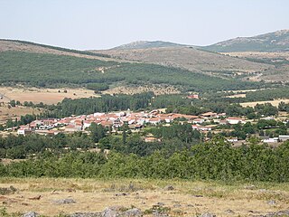
Cereceda de la Sierra is a municipality in the province of Salamanca, western Spain, part of the autonomous community of Castile-Leon. It is located 68 kilometres (42 mi) from the city of Salamanca and as of 2016 had a population of 75 people.

Loznitsa is a small town in northeastern Bulgaria, part of Razgrad Province, located in the geographic region of Ludogorie. It is the administrative centre of the homonymous Loznitsa Municipality, which lies in the southernmost part of the Province. As of December 2009, the town has a population of 2,409 inhabitants.

Samuil is a village in northeastern Bulgaria, part of Razgrad Province, located in the geographic region of Ludogorie. It is the administrative centre of the homonymous Samuil Municipality, which lies in the southeastern part of the Province. As of December 2009, the village has a population of 1,543 inhabitants.

Tervel Municipality is a municipality (obshtina) in Dobrich Province, Northeastern Bulgaria, located in Southern Dobruja geographical region, about 30 km south of Danube river. It is named after its administrative centre - the town of Tervel.
Vidno is a village in Kavarna Municipality, Dobrich Province, northeastern Bulgaria.
Vranino is a village in Kavarna Municipality, Dobrich Province, northeastern Bulgaria.

Avramovo is a village in Ardino Municipality, Kardzhali Province, in southern-central Bulgaria. It is located 187.5 kilometres (116.5 mi) from Sofia, roughly 14 kilometres (8.7 mi) by road southwest of the city of Kardzhali, and roughly 20 kilometres (12 mi) by road east of the municipal town of Ardino.Boyno lies just to the east along the 865 road. It covers an area of 6.197 square kilometres (2.393 sq mi) and as of 2007 had a population of 6 people. Until 1934, the settlement had the name Ibrahimler.

Chubrika is a village in Ardino Municipality, Kardzhali Province, southern-central Bulgaria. It is located 199.97 kilometres (124.26 mi) from Sofia, roughly 21.3 kilometres (13.2 mi) by road southwest of the city of Kardzhali, and roughly 13 kilometres (8.1 mi) by road east of the municipal town of Ardino. To the north is Yabalkovets and to the northeast is Kobilyane, along the 865 road. It covers an area of 5.782 square kilometres (2.232 sq mi) and as of 2007 had a population of 153 people. It was formerly called Fakrŭ Bunar.

Mak is a small hamlet in Ardino Municipality, Kardzhali Province, southern-central Bulgaria. It is located 201.18 kilometres (125.01 mi) from Sofia. It lies at altitude of 561 metres (1,841 ft) to the southeast of Ardino and Sinchets, east of Gurbishte and southwest of Tsarkvitsa. It covers an area of 5.642 square kilometres and as of 2007 had a population of 1 person. The hamlet is dependent on Gurbishte for village functions, where there is also a village hall.

Sinchets is a small mountain village in Ardino Municipality, Kardzhali Province, southern-central Bulgaria. It is located 199.967 kilometres (124.254 mi) from Sofia. It lies at altitude of 770 metres (2,530 ft), 9.8 kilometres (6.1 mi) by winding road to the southeast of Ardino, and north of Tsarkvitsa. It covers an area of 8.602 square kilometres and as of 2007 had a population of 70 people.

Gurbishte is a mountain village in Ardino Municipality, Kardzhali Province, southern-central Bulgaria. It is located 196.78 kilometres (122.27 mi) from Sofia and 13.6 kilometres (8.5 mi) by winding road south of Ardino. It lies to the southwest of Sinchets, and northeast of Padina. It covers an area of 14.494 square kilometres and as of 2007 had a population of 183 people. The village contains a village hall.

Padina is a village in Ardino Municipality, Kardzhali Province, southern-central Bulgaria, located in a valley at the foot of Mount St. Elias (1001m). It is located 195.32 kilometres (121.37 mi) from Sofia,14.8 kilometres (9.2 mi) southwest of Ardino, and 4.8 kilometres (3.0 mi) by road south of Byal izvor. It covers an area of 10.411 square kilometres and as of 2007 had a population of 1030 people, although the population is rapidly declining and 851 were reported in 2010.

Lobbæk is a village in the south of the Danish island of Bornholm, 10 kilometres (6.2 mi) east of Rønne and 6 kilometres (3.7 mi) west of Aakirkeby. It is mainly residential but has a few small firms. As of 2015, it has a population of 351.


