Rittenhouse Gap is the name of a village in Longswamp Township, Berks County, Pennsylvania, at 40°28′04″N75°37′47″W.

Ficheto Point is an ice-free point on the northeast coast of Varna Peninsula, Livingston Island, Antarctica forming the southeast side of the entrance to Dragon Cove. Channel Rock is lying in the adjacent northwestern part of McFarlane Strait, 1.3 km (0.81 mi) northeast of Ficheto Point and 920 m (1,010 yd) south-southwest of Meade Islands. The area was visited by 19th century sealers.

Pluskota is a village in the administrative district of Gmina Wałcz, within Wałcz County, West Pomeranian Voivodeship, in north-western Poland. It lies approximately 5 kilometres (3 mi) north of Wałcz and 126 km (78 mi) east of the regional capital Szczecin.
Koziołek is a village in the administrative district of Gmina Skępe, within Lipno County, Kuyavian-Pomeranian Voivodeship, in north-central Poland.
Ostrów-Kolonia is a village in the administrative district of Gmina Wojsławice, within Chełm County, Lublin Voivodeship, in eastern Poland. It lies approximately 7 kilometres (4 mi) north-west of Wojsławice, 24 km (15 mi) south of Chełm, and 72 km (45 mi) south-east of the regional capital Lublin.
Hucisko is a village in the administrative district of Gmina Drużbice, within Bełchatów County, Łódź Voivodeship, in central Poland. It lies approximately 6 kilometres (4 mi) south-east of Drużbice, 11 km (7 mi) north-east of Bełchatów, and 39 km (24 mi) south of the regional capital Łódź.
Młogoszyn is a village in the administrative district of Gmina Krzyżanów, within Kutno County, Łódź Voivodeship, in central Poland. It lies approximately 6 kilometres (4 mi) south of Krzyżanów, 13 km (8 mi) south-east of Kutno, and 40 km (25 mi) north of the regional capital Łódź.
Sambórz is a village in the administrative district of Gmina Burzenin, within Sieradz County, Łódź Voivodeship, in central Poland. It lies approximately 2 kilometres (1 mi) north-west of Burzenin, 16 km (10 mi) south of Sieradz, and 58 km (36 mi) south-west of the regional capital Łódź.
Rzeplin is a village in the administrative district of Gmina Ulhówek, within Tomaszów Lubelski County, Lublin Voivodeship, in eastern Poland, close to the border with Ukraine. It lies approximately 6 kilometres (4 mi) east of Ulhówek, 31 km (19 mi) east of Tomaszów Lubelski, and 125 km (78 mi) south-east of the regional capital Lublin.
Brzezie is a village in the administrative district of Gmina Opatów, within Opatów County, Świętokrzyskie Voivodeship, in south-central Poland. It lies approximately 4 kilometres (2 mi) east of Opatów and 61 km (38 mi) east of the regional capital Kielce.
Pomiechowo is a village in the administrative district of Gmina Pomiechówek, within Nowy Dwór Mazowiecki County, Masovian Voivodeship, in east-central Poland. It lies approximately 2 kilometres (1 mi) south-west of Brody-Parcele, 6 km (4 mi) north-east of Nowy Dwór Mazowiecki, and 34 km (21 mi) north-west of Warsaw.
Bugaj is a village in the administrative district of Gmina Pobiedziska, within Poznań County, Greater Poland Voivodeship, in west-central Poland.

Duncans is a settlement in Jamaica.
Porta Monforte is a district ("quartiere") of Milan, Italy, located within the Zone 3 administrative division. It is named after the eponymous city gate, which was added in the 1890s to the existing Spanish walls of the city. The gate was meant to serve as a customs office; the tax booths were designed by Luigi Tormenti and completed in 1889. While the addition of the Monforte city gate was intended to absorb part of the traffic going through Porta Venezia and Porta Vittoria, Porta Monforte remained a minor gate. The gate itself has since been demolished; it was located in what is now Piazza del Tricolore.

Lipen Glacier is a 5 km long and 3.5 km wide glacier draining the east slopes of the Trojan Range on Anvers Island in the Palmer Archipelago, Antarctica. Situated east of Iliad Glacier and north of Rhesus Glacier. Flowing northeastwards into the head of Patagonia Bay east of Gourdon Peninsula and west of Thompson Peninsula.
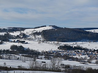
Mathesberg is a mountain of Hesse, located in the Rhön Mountains, Germany.
Kalmu is a village in Saaremaa Parish, Saare County in western Estonia.

Santa Maria alla Scala was a church built in the gothic style in Milan in 1381 and named in honour of Beatrice Regina della Scala, the wife of Bernabò Visconti who commissioned the building. The church was demolished in 1776 to make way for the ducal theatre which became the Teatro alla Scala.

Eskişehir Yeni Atatürk Stadyumu is a stadium Eskişehir, Turkey. It opened to the public in late October 2016 and has a capacity of 32,507 spectators. It is the home ground of Eskişehirspor. It replaced the club's former home, Eskişehir Atatürk Stadium.
Capaldo was an unincorporated community in Crawford County, Kansas, United States. It is currently part of the city of Frontenac, and located northwest of the Frontenac Industrial Park #1.


