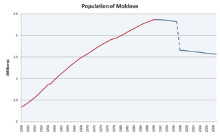
This article is about the demographic features of the population of Moldova, including distribution, ethnicity, languages, religious affiliation and other statistical data.
Bulgarians are a nation and South Slavic ethnic group native to Bulgaria and its immediate region.

Gagauzia or Gagauz Yeri, officially the Autonomous Territorial Unit of Gagauzia, is an autonomous region of Moldova. Its autonomy is ethnically motivated by the predominance of the Gagauz people, who are primarily Orthodox Turkic-speaking people. Gagauz Yeri literally means "place of the Gagauz".

The Gagauzes are a Turkic people living mostly in southern Moldova, southwestern Ukraine (Budjak), northeastern Bulgaria, Greece, Brazil, the United States, and Canada. The Gagauz are Eastern Orthodox Christians.

Varna Province, formerly known as Varna okrug, is a province in eastern Bulgaria, one of the 28 Bulgarian provinces. It comprises 12 municipalities with a population of 494,216 inhabitants as of April 2016. The province is named after its administrative centre, Varna.

Pomorie is a town and seaside resort in southeastern Bulgaria, located on a narrow rocky peninsula in Burgas Bay on the southern Bulgarian Black Sea Coast.
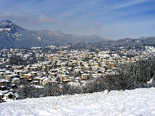
Smolyan is a town and ski resort in the far south of Bulgaria near the border with Greece. It is the administrative and industrial centre of the homonymous Smolyan Province. The town is situated in the valley of the Cherna ("Black") and the Byala ("White") Rivers in the central Rhodopes at the foot of the mountains' highest part south of the popular ski resorts Pamporovo and Chepelare. As of February 2011, it has a population of 30,283 inhabitants.
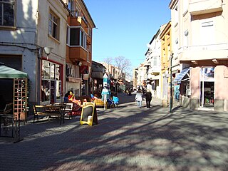
Asenovgrad is a town in central southern Bulgaria, part of Plovdiv Province. It is the largest town in Bulgaria that is not a province center. In 1934 it was renamed in honor of Tsar Ivan Assen II of Asenovgrad.

Kavarna is a Black Sea coastal town and seaside resort in the Dobruja region of northeastern Bulgaria. It lies 64 kilometres northeast of Varna, 49 km (30 mi) from Dobrich on the international road E87 and 43 km (27 mi) south of the border with Romania. It is the principal town of Kavarna Municipality, part of Dobrich Province. As of December 2009, the town has a population of 11,397 inhabitants. A little yacht port, a fishing base, a spacious beach and a resort complex exist in the town. The landmark Cape Kaliakra is located a few kilometers to the east, as is the tiny beachfront resort of Rusalka. Three 18-hole golf courses with villa communities and marinas are being developed nearby, two of the courses are designed by Gary Player and one by Ian Woosnam.
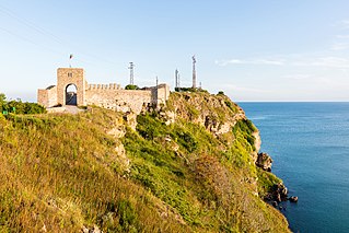
Kaliakra is a long and narrow headland in the Southern Dobruja region of the northern Bulgarian Black Sea Coast, 12 kilometres (7 mi) east of Kavarna, 60 kilometres (37 mi) northeast of Varna and 65 kilometres (40 mi) southwest of Mangalia. The coast is steep with vertical cliffs reaching 70 metres (230 ft) down to the sea. Kaliakra is a nature reserve, where dolphins and cormorants can be observed. It sits on the Via Pontica, a major bird migration route from Africa into Eastern and Northern Europe. Many rare and migrant birds can be seen here in spring and autumn and, like much of this coastline, is home to several rare breeding birds. The rest of the reserve also has unusual breeding birds; saker falcon, lesser grey shrike and a host of others.

Arbanasi is a village in Veliko Tarnovo Municipality, Veliko Tarnovo Province of central northern Bulgaria, set on a high plateau between the larger towns of Veliko Tarnovo and Gorna Oryahovitsa. It is known for the rich history and large number of historical monuments, such as 17th- and 18th-century churches and examples of Bulgarian National Revival architecture, which have turned it into a popular tourist destination.

Misthi or Misti, was a Greek city in the region of Cappadocia, in what is now Turkey. It was situated 82 kilometres southwest of the regional capital of Caesarea, nowadays Kayseri, Turkey, and belonged administratively to the nearby city of Nigde, 26 kilometres north-northwest and at an altitude of 1380 metres above sea level.

Polykastro is a town and a former municipality in Kilkis regional unit of Central Macedonia, Greece. Since the 2011 local government reform it is part of the municipality Paionia, of which it is a municipal unit, and the seat. The municipal unit has an area of 312.717 km2, the municipal unit 45.775 km2. The municipal unit of Polykastro has 12,000 inhabitants, and includes Polykastro and 23 villages. It is built near the Axios River, on the road and railway from Thessaloniki to Belgrade. It was formerly known as Karasuli (Turkish), Mavrosuli or Rugunovec.

Maglizh is a town in Stara Zagora Province, South-central Bulgaria. It is the administrative centre of the homonymous Maglizh Municipality. As of December 2009, the town has a population of 3,426 inhabitants.

Samuil is a village in northeastern Bulgaria, part of Razgrad Province, located in the geographic region of Ludogorie. It is the administrative centre of the homonymous Samuil Municipality, which lies in the southeastern part of the Province. As of December 2009, the village has a population of 1,543 inhabitants.
Leventochori is a village in the municipality of Kilkis, Kilkis regional unit, Greece. 6 km southwest of the city centre, it is part of the community of Mesiano. In 2001, it had a population of 266. According to the Bulgarian ethnographer Vasil Kanchov, the village had 140 inhabitants in 1900, all of them of Turkish origin. Its present population consists of descendants of refugees from the village Harapa near Tsalka in Georgia and from other parts of the Caucasus and Eastern Thrace, and some Sarakatsanoi families. The village has a church of the saints Constantine and Helena.
Panagia is a village in the northeastern part of the island of Lemnos, Greece. It is part of the municipal unit of Moudros. In 2011 its population was 383 people, including the small village Kortisonas.
Kilkis is a city in Central Macedonia, Greece. As of 2011 there were 22,914 people living in the city proper, 28,745 people living in the municipal unit, and 51,926 in the municipality of Kilkis. It is also the capital city of the regional unit of Kilkis.
Vythos is a village in Kozani regional unit, West Macedonia, Greece. Since the 2011 local government reform it is part of the municipality Voio, of which it is a member of the municipality unit of Pentalofos. Βυθὀς means seabed, which is a paradoxical name for a village typified by its mountainous terrain and high altitude.


