
Kiihtelysvaara is a former municipality of Finland. On January 1, 2005 it was consolidated, together with Tuupovaara, with the city of Joensuu.
The University of Cassino and Southern Lazio is an Italian public research university located in Cassino, Italy. It was established in 1979.

Rathaus Neukölln is a Berlin U-Bahn station located on the U 7. It was built in 1926 by A. Grenander. The platform was extended in 1968. In 1989 a lift was built in. It was the first subway station in Neukölln that was handicap-accessible. The next stop is Karl-Marx-Straße.

Sunagawa Station is a railway station on the Hakodate Main Line of Hokkaido Railway Company, located in Sunagawa, Hokkaidō, Japan, opened in 1891. The station previously served the closed Utashinai Line and Kamisunagawa Branch Line.
Jargaltkhaan is a sum (district) of Khentii Province in eastern Mongolia.

Hafar Al-Batin is a Saudi Arabian city in the Eastern Province. It is located 430 km north of Riyadh, 94.2 km from the Kuwait border, and about 74.3 from the Iraq border. The city lies in the dry valley of the Wadi al-Batin, which is part of the longer valley of the river Wadi al-Rummah, which leads inland toward Medina and formerly emptied into the Persian Gulf.

Brzezina is a village in the administrative district of Gmina Twardogóra, within Oleśnica County, Lower Silesian Voivodeship, in south-western Poland. Prior to 1945 it was in Germany.
Jaczno is a village in the administrative district of Gmina Dąbrowa Białostocka, within Sokółka County, Podlaskie Voivodeship, in north-eastern Poland. It lies approximately 6 kilometres (4 mi) east of Dąbrowa Białostocka, 28 km (17 mi) north of Sokółka, and 62 km (39 mi) north of the regional capital Białystok.
Kociszew is a village in the administrative district of Gmina Zelów, within Bełchatów County, Łódź Voivodeship, in central Poland. It lies approximately 7 kilometres (4 mi) north-east of Zelów, 15 km (9 mi) north of Bełchatów, and 35 km (22 mi) south of the regional capital Łódź.
Książ Mały-Kolonia is a village in the administrative district of Gmina Książ Wielki, within Miechów County, Lesser Poland Voivodeship, in southern Poland. It lies approximately 7 kilometres (4 mi) east of Książ Wielki, 17 km (11 mi) north-east of Miechów, and 47 km (29 mi) north-east of the regional capital Kraków.
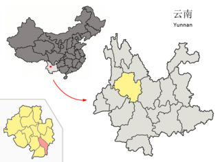
Midu County is a county in the Dali Bai Autonomous Prefecture located in west-central Yunnan province, China.
Pagórki is a village in the administrative district of Gmina Wierzbinek, within Konin County, Greater Poland Voivodeship, in west-central Poland.

Cốc Đán is a commune (xã) and village in Ngân Sơn District, Bắc Kạn Province, in Vietnam.
The Chesapeake Bay National Estuarine Research Reserve contains a diverse collection of habitats including oyster reefs, seagrass beds, tidal wetlands, sandy shoals and mudflats. In order to address the diversity of habitats, the Chesapeake Bay-Virginia Reserve established a multi-site system from tidal freshwater to high salinity conditions along the York River estuary. Reserve components include Sweet Hall Marsh, Taskinas Creek, Catlett Island and Goodwin Islands.

Phanagoria Island is the third largest island in the Zed group off the north coast of Livingston Island in the South Shetland Islands, Antarctica. The island is ice-free, extending 700 by 500 m with surface area 20 hectares. Separated from the neighbouring Esperanto Island and Lesidren Island by channels 70 and 130 m wide respectively. Situated 2.1 km (1.3 mi) northwest of Williams Point. The area was visited by early 19th century sealers.

Kosovica is a village in the municipality of Ivanjica, Serbia. According to the 2011 census, the village has a population of 159 inhabitants.
Srndalje is a village in the municipality of Kruševac, Serbia. According to the 2002 census, the village has a population of 66 people.
The Emil River or Emin River, also spelled Emel, Imil, etc., is a river in China and Kazakhstan. It flows through Tacheng (Tarbagatay) Prefecture of China's Xinjiang Uighur Autonomous Region and the East Kazakhstan Province of Kazakhstan, and is one of the principal affluents of Lake Alakol.

Zagorani is a village in Municipality of Prilep, Republic of Macedonia.

Arapiles is a ward (barrio) of Madrid belonging to the district of Chamberí.


