Irgenhausen Castrum

Last updated • 4 min readFrom Wikipedia, The Free Encyclopedia

Irgenhausen Castrum
(Kleinkastell Irgenhausen)
Irgenhausen - Castrum IMG 8164.JPG
The Castrum as seen from the west
Alternative nameunknown
LimesDanube-Iller-Rhine Limes
(Maxima Sequanorum, rearward line)
Date(s) occupied Valentinian II, 4th to 5th century
Typeroad respectively hill castle
Unit/Formationunknown
Size60 metres (197 ft)× 61 metres (200 ft) (0.36 hectares (0.9 acres))
Constructionstone construction
Conditioncompletely excavated, conserved and partly reconstructed
Location Irgenhausen, Canton of Zürich, Switzerland
Coordinates 47°21′30″N8°47′33″E / 47.358333°N 8.7925°E / 47.358333; 8.7925
Height562 m
Previous fort Turicum Castrum  [ en ] (Turicum) (west)
Fort in front Vitudurum Castrum  [ en ] (Vitudurum) (north)

Irgenhausen Castrum is a Roman fort at Irgenhausen, situated on Pfäffikersee lake shore in Switzerland. It was a square fort, measuring 60 metres (197 ft) in square, with four corner towers and three additional towers. The remains of a stone wall in the interior were probably a spa.

Contents

Geography

As seen from the south Irgenhausen - castrum IMG 5409.jpg
As seen from the south
As seen from the northwest Irgenhausen - castrum IMG 5388.jpg
As seen from the northwest
As seen from the southeast Irgenhausen castrum (S) IMG 3436.JPG
As seen from the southeast

The castrum is situated on the Bürglen hill in Irgenhausen, a village of the municipality of Pfäffikon in the canton of Zürich in Switzerland. Bürglen (Swiss German: "small castle") is a 25 metres (82 ft) high drumlin, 400 metres (1,312 ft) from the eastern shore of Pfäffikersee, situated between Pfäffikon and Kempten, the site of another Roman settlement nearby.

History

In the Roman era, along Pfäffikersee there was a Roman road from Centum Prata (Kempraten) on OberseeLake Zürich via Vitudurum (Oberwinterthur) to Tasgetium (Eschenz) on the Rhine. To secure this important transport route, the castrum was built. The native name of the fort is unknown; Irgenhausen was mentioned in AD 811 as Camputuna sive Irincheshusa, so maybe the castrum's name was Cambodunum, the Roman name of the neighboring village of Kempten.

In 1865, Jakob Messikommer succeeded the dating of finds at Irgenhausen, because of his experience in the dating of peat and concurrent findings at the Irgenhausen Castrum. [1] In 1897, stones of the ruined building (believed at the time to be those of a medieval castle) were used for the construction of a factory nearby; the dilapidation was stopped by the Antiquarische Gesellschaft in Zürich in order to start archaeological investigations, carried out between 1898 and 1908, and to preserve the walls. The castrum was set under federal protection as "Kastell Irgenhausen" in 1909. Walter Mittelholzer made an aerial exploration of the fort and the surrounding area, whereupon in the closer environment Roman villae rusticae , among them one in Kempten, were localized and excavated. In 1957, the land and the castle were sold to the community of Pfäffikon.

Architecture

Excavations in 1907 showing the hypocaustum of the villa rustica, with the castle wall to the left Irgenhausen castrum 1907 IMG 3391.jpg
Excavations in 1907 showing the hypocaustum of the villa rustica , with the castle wall to the left

For the dating of the fort there are two theories: the first assumes that the fort was built at the time of the Emperor Diocletian around AD 294–295. The other theory, based on the Roman coins found inside the castrum, dated the construction from 364 to 375, in the era of the Emperor Valentinian II. As early as AD 400 the castrum was evacuated and destroyed by Alamanni invaders.

The excavations restored a 1.4 metres (5 ft) high foundation wall that has an almost square outline of 60 metres (197 ft) x 61 metres (200 ft), and thus an area of only 0.366 hectares. The fort had four corner towers (8 metres (26 ft) x 8 metres (26 ft)), a gate tower on the southeast side and three low towers on the north, west and south front (6 metres (20 ft)), and an approximately 1.9 metres (6 ft) strong enclosing wall. The materials used by the Roman soldiers derived from glacial deposits, furthermore, there is a mixture of sernifit from Glarus, limestone and conglomerate. The walls of the towers measure between 1.2 metres (4 ft) up to 1.4 metres (5 ft). The main access was from the south through the gate in the middle of the eastern front. The other three sides hide small side entrances.

In addition to the remains of the towers and surrounding wall, there were found the remains of stone interior buildings: a three-roomed building was seen as a spa. Another building with three rooms has been interpreted as principia, (lit. "primary buildings"), the headquarters of the fort. At the southern corner tower a hypocaust system of an older villa rustica from the 1st to the 3rd century was excavated. The other buildings were made of wood and therefore cannot be individually identified. However, some military barracks, a horreum and a praetorium was probably built inside the fort. In the middle of the hill there was a sunken room. Most of the relics found inside the fort date from the 2nd and 3rd centuries AD and are thought to be relics of the villa rustica on whose ruins the fort was built. At the present time, a red ribbon in the wall shows where the Roman wall ends and the restored wall begins.

Cultural heritage

The building is listed in the Swiss inventory of cultural property of national and regional significance as a Class B object of regional importance. [2]

Literature

Related Research Articles

<span class="mw-page-title-main">Wetzikon</span> Municipality in Zurich, Switzerland

Wetzikon is a small town in the Zurich Highlands area of Switzerland, in the district of Hinwil in the canton of Zürich.

<span class="mw-page-title-main">Zürcher Oberland</span> Highlands in Switzerland

The Zürcher Oberland in Switzerland, is the hilly south-eastern part of the canton of Zürich, bordering on the Toggenburg, including the districts of Uster, Hinwil, Pfäffikon as well as the Töss Valley as far as the district of Winterthur. The territory gradually fell under the control of the city of Zürich from 1408 to 1452. In the 18th century, the jurisdiction lay with the reeve of Grüningen for the southern part, and with the reeve of Kyburg for the northern part together with most of the Zürcher Unterland.

<span class="mw-page-title-main">Pfäffikon, Zürich</span> Municipality in Zürich, Switzerland

Pfäffikon is a municipality in the canton of Zürich in Switzerland. It is the seat of the district of the same name. It is not to be confused with Pfäffikon SZ on Lake Zurich but in the canton of Schwyz.

<span class="mw-page-title-main">Pfäffikersee</span>

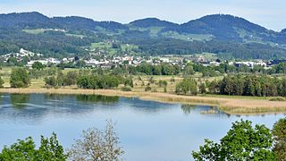
Pfäffikersee is a lake in the canton of Zürich, Switzerland, near the town of Pfäffikon. It is 2.5 km long and 1.3 km wide at the middle. The lake was created in the last ice age when a moraine blocked off the ability for the lake to empty north towards Winterthur. There is also a hiking trail around the lake that people often bike and walk on, and the area is considered protected lands, among them the Robenhauser Ried and the prehistoric settlement Wetzikon–Robenhausen, discovered and researched by Jakob Messikommer (1828–1917), which became a serial site of the UNESCO World Heritage Site Prehistoric pile dwellings around the Alps. In Roman era, along Pfäffikersee there was a Roman road from the vicus Centum Prata (Kempraten) on Obersee–Lake Zürich via Vitudurum (Oberwinterthur) to Tasgetium (Eschenz) to the Rhine. To secure this important transport route, the Irgenhausen Castrum was built.

<span class="mw-page-title-main">Villa rustica</span> Countryside farmhouse or villa during the Roman era

Villa rustica was the term used by the ancient Romans to denote a farmhouse or villa set in the countryside and with an agricultural section, which applies to the vast majority of Roman villas. In some cases they were at the centre of a large agricultural estate, sometimes called a latifundium. The adjective rustica was used only to distinguish it from a much rarer sub-urban resort villa, or otium villa built for purely leisure and luxury, and typically located in the Bay of Naples. The villa rustica would thus serve both as a residence of the landowner and his family and also as a farm management centre. It would often comprise separate buildings to accommodate farm labourers and sheds and barns for animals and crops.

<span class="mw-page-title-main">Kempraten</span> Former municipality of Switzerland in St. Gallen

Kempraten-Lenggis is a village (Kirchdorf) within the municipality of Rapperswil-Jona, Wahlkreis (constituency) of See-Gaster in the canton of St. Gallen in Switzerland. The remains of the Gallo-Roman settlement Centum Prata are one of the most important archaeological sites in the canton of St. Gallen; Centrum Prata is located at the so-called Kempratnerbucht, in Rapperswil and Busskirch on Zürichsee lake shore.

<span class="mw-page-title-main">Pfannenstiel (Zürich)</span> Mountain in Switzerland

Pfannenstiel is a wooded mountain respectively a region overlooking the Lake Zürich and Zürcher Oberland in the canton of Zürich in Switzerland.

<span class="mw-page-title-main">S3 (ZVV)</span> Railway service in Switzerland

The S3 is a regional railway service of the Zürich S-Bahn on the Zürcher Verkehrsverbund (ZVV), the Zürich transportation network. It is operated by Swiss Federal Railways.

<span class="mw-page-title-main">Auslikon</span> Former municipality in Zurich, Switzerland

Auslikon is a village of the municipality of Pfäffikon in the canton of Zurich in Switzerland.

<span class="mw-page-title-main">Irgenhausen</span> Former municipality of Switzerland in Zurich

Irgenhausen is a village of the municipality of Pfäffikon in the canton of Zurich in Switzerland.

<span class="mw-page-title-main">Kempten, Switzerland</span> Former municipality in Zurich, Switzerland

Kempten is a locality of the municipality of Wetzikon in the canton of Zurich in Switzerland.

<span class="mw-page-title-main">Wetzikon–Meilen tramway</span>

The Wetzikon–Meilen tramway was a metre gauge rural electric tramway in the Swiss canton of Zürich. It linked the town of Meilen, on the shore of Lake Zürich, with Wetzikon and Kempten in the Zürcher Oberland.

<span class="mw-page-title-main">Turicum</span> Former Gallo-Roman settlement in Switzerland

Turicum was a Gallo-Roman settlement at the lower end of Lake Zurich, and precursor of the city of Zürich. It was situated within the Roman province of Germania Superior) and near the border to the province of Raetia; there was a tax-collecting point for goods traffic on the waterway Walensee–Obersee-Zürichsee–Limmat–Aare–Rhine.

<i>Zürcher Oberländer</i>

Zürcher Oberländer, commonly shortened to ZOL, is a Swiss German-language daily newspaper, published in Wetzikon.

<span class="mw-page-title-main">Robenhausen</span>

Robenhausen is a locality in Wetzikon, one of the municipalities of the canton of Zürich, Switzerland. The wetland Robenhauser Ried belongs to the protected area surrounding Pfäffikersee. The prehistoric pile dwelling around Lake Zurich Wetzikon-Robenhausen is part of the UNESCO-defined World Heritage Sites, the prehistoric pile dwellings around the Alps.

<span class="mw-page-title-main">Vitudurum</span> Former Roman Vicus in Switzerland

Vitudurum is the name of a Roman vicus, those remains are located in Oberwinterthur, a locality of the municipality of Winterthur in the canton of Zürich in Switzerland.

<span class="mw-page-title-main">Wetzikon-Robenhausen</span> Prehistoric pile dwelling on Pfäffikersee lakeshore in Robenhausen, Switzerland

Wetzikon–Robenhausen is one of the 111 serial sites of the UNESCO World Heritage Site Prehistoric pile dwellings around the Alps, of which are 56 located in Switzerland. The site is located on Pfäffikersee lakeshore in Robenhausen, a locality of the municipality of Wetzikon in the Canton of Zürich in Switzerland.

<span class="mw-page-title-main">Jakob Messikommer</span> Swiss archaeologist

Jakob Messikommer was a Swiss archaeologist who among others discovered and researched the UNESCO serial site Wetzikon–Robenhausen.

<span class="mw-page-title-main">Jakob Heusser-Staub</span>

Jakob Heusser-Staub was a Swiss industrialist and philanthropist. Born and raised in the village of Irgenhausen, Heusser-Staub made Uster his home. With the support of his wife, Berta, he founded the Heusser-Staub foundation.

<span class="mw-page-title-main">St. Francis's Church, Wetzikon</span> Swiss church

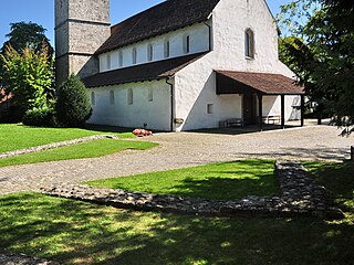
The Church of Saint Francis is a Roman Catholic parish church located in Wetzikon, Switzerland.

References

  1. "Jakob Messikommer" (in German). wetzikon.ch. Retrieved 16 September 2015.
  2. "B-Objekte KGS-Inventar" (PDF). Schweizerische Eidgenossenschaft, Amt für Bevölkerungsschutz. 18 February 2015. Archived from the original (PDF) on 1 October 2015. Retrieved 18 September 2015.