Ironstone Plateau

Last updated
Ironstone Plateau
South Sudan adm location map.svg
Red pog.svg
Ironstone Plateau
Coordinates: 5°58′N27°23′E / 5.96°N 27.39°E / 5.96; 27.39 Coordinates: 5°58′N27°23′E / 5.96°N 27.39°E / 5.96; 27.39
LocationSouth Sudan
Elevation
900 m (3,000 ft)

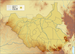
The Ironstone Plateau (jabal hadid) is a region in the south and west of South Sudan.

Contents

Topology and rainfall

The land in the south and west of South Sudan slopes down to the northeast from the Nile-Congo Divide towards the Bahr el Ghazal swamps. The divide is formed by a plateau rising 800 to 1,000 metres (2,600 to 3,300 ft) above sea level, with some peaks that rise to 1,700 metres (5,600 ft). Rainfall is higher on the plateau than in the lower clay floodplains. [1] The rainy season lasts from May until November. Annual rainfall is 700 to 900 millimetres (28 to 35 in). [2] The plateau drains into the floodplain through rivers that cross an ironstone peneplain and then spread out into deltas and swamps. [1] The soils of the plateau have little capacity to hold water, so most of the run-off drains into the floodlands. [3] The many streams draining the plateau have formed steep and narrow valleys. [4]

Soil and vegetation

The Ironstone Plateau takes its name from the hard red lateritic soil called ironstone that covers almost the entire area. These soils are often thin and may be unsuitable for agriculture, except in the Green Belt in the extreme southwest of Western Equatoria and in a region around the Acholi Mountains in the Torit County of Eastern Equatoria. [5] The country north and east of the ironstone plateau is covered in clayish black cotton soil, mostly grasslands that are prone to flooding. The black cotton soil cracks when it is dry, but expands and becomes sticky in the rain, making travel difficult. The ironstone plateau has more trees and travel is easier. [6] The plateau and peneplain are mostly wooded. [1]

People and economy

The people of the plateau generally speak Ubangian languages while the people of the floodplains are Nilotic. [7] The plateau population includes Zande in Western Equatoria and Bari speakers in Central Equatoria on either side of the Nile. [8] They raise some livestock and engage in rain-fed agriculture, growing cereals such as Sorghum and pearl millet, vegetables and cassava in mixed croppings. [9] Other crops are oil seeds, groundnuts, sesame, cowpeas and okra, and mangoes, citrus and melons. [2] The best soil for agriculture is beside the streams that drain the plateau. [4] The forests yield mahogany from the Raga region and plantation teak. [2]

Related Research Articles

<span class="mw-page-title-main">Geography of Egypt</span> Geographical features of Egypt

The geography of Egypt relates to two regions: North Africa and Southwest Asia.

<span class="mw-page-title-main">Geography of Sudan</span> Geographical features of Sudan

Sudan is located in Northeast Africa. It is bordered by Egypt to the north, the Red Sea to the northeast, Eritrea and Ethiopia to the east, South Sudan to the south, the Central African Republic to the southwest, Chad to the west and Libya to the northwest. Sudan is the third largest country in Africa, after Algeria and the Democratic Republic of the Congo. It had been the largest country on the continent until the 2011 independence of South Sudan.

<span class="mw-page-title-main">White Nile</span> River originating in Burundi or Rwanda

The White Nile is a river in Africa, one of the two main tributaries of the Nile, the other being the Blue Nile. The name comes from the clay sediment carried in the water that changes the water to a pale color.

<span class="mw-page-title-main">Sudd</span> Swamp in South Sudan

The Sudd is a vast swamp in South Sudan, formed by the White Nile's Baḥr al-Jabal section. The Arabic word sudd is derived from sadd, meaning "barrier" or "obstruction". The term "the sudd" has come to refer to any large solid floating vegetation island or mat. The area which the swamp covers is one of the world's largest wetlands and the largest freshwater wetland in the Nile Basin.

<span class="mw-page-title-main">Jonglei State</span> State of South Sudan

Jonglei State is a state of South Sudan with Bor as its centre of government and the biggest city. Jonglei state comprises nine counties: Bor, Akobo, Ayod, Uror, Duk, Nyirol, Pigi, Twic East, and Fangak. Jonglei State is the largest state by area before reorganisation, with an area of approximately 122,581 km2, as well as the most populous according to the 2008 census conducted in present-day South Sudan's second period of autonomy. The boundaries of the state were again changed as a result of a peace agreement signed on 22 February 2020.

<span class="mw-page-title-main">Dinka people</span> Nilotic ethnic group native to South Sudan

The Dinka tribe are a Nilotic ethnic group native to South Sudan with a sizable diaspora population abroad. The Dinka mostly live along the Nile, from Bor to Renk, in the region of Bahr el Ghazal, Upper Nile, and the Abyei Area of the Ngok Dinka in South Sudan.

<span class="mw-page-title-main">Cumberland Plain</span> Plain in Australia

The Cumberland Plain, an IBRA biogeographic region, is a relatively flat region lying to the west of Sydney CBD in New South Wales, Australia. Cumberland Basin is the preferred physiographic and geological term for the low-lying plain of the Permian-Triassic Sydney Basin found between Sydney and the Blue Mountains, and it is a structural sub-basin of the Sydney Basin.

The biomes and ecoregions in the ecology of Zambia are described, listed and mapped here, following the World Wildlife Fund's classification scheme for terrestrial ecoregions, and the WWF freshwater ecoregion classification for rivers, lakes and wetlands. Zambia is in the Zambezian region of the Afrotropical biogeographic realm. Three terrestrial biomes are well represented in the country . The distribution of the biomes and ecoregions is governed mainly by the physical environment, especially climate.

<span class="mw-page-title-main">Jur River</span> River in South Sudan

The Jur River is a river in western South Sudan, flowing through the Bahr el Ghazal and Equatoria regions. About 485 kilometres (301 mi) long, it flows north and northeast, joining the Bahr el Ghazal River on the western side of the Sudd wetlands. The Jur River is part of the Nile basin, as the Bahr al-Ghazal flows into the White Nile.

<span class="mw-page-title-main">Agriculture in Sudan</span> Economic sector in Sudan

Agriculture in Sudan plays an important role in that country's economy. Agriculture and livestock raising are the main sources of livelihood for most of the Sudanese population. It was estimated that, as of 2011, 80 percent of the labor force were employed in that sector, including 84 percent of the women and 64 percent of the men.

<span class="mw-page-title-main">Jonglei Canal</span> Uncompleted canal project

The Jonglei Canal was a canal project started, but never completed, to divert water from the vast Sudd wetlands of South Sudan so as to deliver more water downstream to Sudan and Egypt for use in agriculture. Sir William Garstin proposed the idea of the canal in 1907; the government of Egypt conducted a study in 1946; and plans took shape between 1954 and 1959 during the period of decolonization which included Sudanese independence in 1956. Against the context of Sudan's postcolonial civil conflict, the Sudan People's Liberation Army (SPLA), led by John Garang, halted construction of the canal in 1984.

<span class="mw-page-title-main">Imatong Mountains</span> Mountains in South Sudan

The Imatong Mountains are mainly located in Eastern Equatoria in southeastern South Sudan, and extend into the Northern Region of Uganda. Mount Kinyeti is the highest mountain of the range at 3,187 metres (10,456 ft), and the highest point of South Sudan.

The Machar Marshes are a large area of wetlands in the state of Upper Nile, South Sudan. Estimates of their size vary. A 1950 study put the area of swamp at 6,500 km2. A 1980 study put the area of permanent swamp at 8,700 km2., 60% of which was grass and forest.

The Kinyeti River flows northward from the Imatong Mountains in the Imatong State of South Sudan, eventually dispersing into the Badigeru swamp.

The Badigeru swamp swamp lies in South Sudan, in the Central Equatoria and Eastern Equatoria states between Terekeka and Lafon.

<span class="mw-page-title-main">Mongalla, South Sudan</span> Payam in Central Equatoria, South Sudan

Mongalla or Mangalla is a Payam in Juba County, Central Equatoria State in South Sudan, on the east side of the Bahr al Jebel or White Nile river. It lies about 75 km by road northeast of Juba. The towns of Terekeka and Bor lie downstream, north of Mongalla.

Terekeka County is an administrative division of Central Equatoria in South Sudan. And it is the headquarter of other Mundari counties and boma, it's lying on the west bank of the White Nile 85 north of Juba. "Terekeka" means "the forgotten" in Mundari local dialect.

<span class="mw-page-title-main">Adar oilfield</span> Oilfield in South Sudan

The Adar oilfield, also known as the Adar Yale, Adar Yeil or Adaril field, is an oilfield situated in the Melut in South Sudan estimated to contain about 276 million barrels (43,900,000 m3) of oil. The Chevron Corporation discovered the Adar Yale field in 1981, shortly before the start of the Second Sudanese Civil War (1983–2005). Soon after Chevron had suspended operations in 1984, Sudanese government troops began attacking civilian settlements in the area, burning the houses and driving the people away, and in the late 1990s, Nuer militias from Nasir helped the army in clearing away the people to make way for the roads and infrastructure of the oilfield.

<span class="mw-page-title-main">Congo-Nile Divide</span>

The Congo-Nile Divide is the continental divide that separates the drainage basins of the Nile and Congo rivers. It is about 2,000 kilometres (1,200 mi) long.

The Tonj River, also called the Ibba River or Nyatt Ayok, is a river of South Sudan. It is a right tributary of the Bahr el Ghazal River.

References

Citations

  1. 1 2 3 Howell & Allan 1994, p. 269.
  2. 1 2 3 Potential in the Agricultural Sector: Riverbend.
  3. Howell & Allan 1994, p. 282.
  4. 1 2 Barbour 1961, p. 319.
  5. Beswick 2004, p. 12.
  6. Ryle 2011, p. 17.
  7. Badal 1994, p. 108.
  8. Ryle 2011, p. 41.
  9. Howell & Allan 1994, p. 207.

Sources