Raga, South Sudan

Last updated • 1 min readFrom Wikipedia, The Free Encyclopedia
Raga
Town
South Sudan adm location map.svg
Red pog.svg
Raga
Location in South Sudan
Coordinates: 08°28′12″N25°40′48″E / 8.47000°N 25.68000°E / 8.47000; 25.68000
CountryFlag of South Sudan.svg  South Sudan
Region Bahr el Ghazal
State Western Bahr el Ghazal
County Raga County
Elevation
1,788 ft (545 m)
Population
 (2010 Estimate)
  Total3,700
Time zone UTC+2 (CAT)

Raga is a town in South Sudan.

Location

The town is located in the Raga County of Western Bahr el Ghazal, in the Bahr el Ghazal region of South Sudan, [1] near the International borders with the Republic of Sudan and the Central African Republic. It is located approximately 300 kilometres (190 mi), by road, northwest of Wau, the capital of Western Bahr el Ghazal State. This location lies approximately 950 kilometres (590 mi), by road, northwest of Juba, the capital and largest city in that country. [2] The coordinates of Raga are: 8° 28' 12.00"N, 25° 40' 48.00"E (Latitude: 8.4700; Longitude: 25.6800). Raga's average elevation is 545 metres (1,788 ft) above sea level. [3]

Contents

Climate

Köppen-Geiger climate classification system classifies its climate as tropical wet and dry (Aw).

Climate data for Raga (1961–1990)
MonthJanFebMarAprMayJunJulAugSepOctNovDecYear
Record high °C (°F)40.6
(105.1)
41.6
(106.9)
43.7
(110.7)
42.7
(108.9)
41.5
(106.7)
39.0
(102.2)
36.7
(98.1)
36.2
(97.2)
36.4
(97.5)
38.2
(100.8)
38.7
(101.7)
40.3
(104.5)
43.7
(110.7)
Mean daily maximum °C (°F)34.2
(93.6)
35.8
(96.4)
37.3
(99.1)
37.5
(99.5)
35.1
(95.2)
32.5
(90.5)
30.7
(87.3)
30.8
(87.4)
31.8
(89.2)
33.2
(91.8)
34.6
(94.3)
34.2
(93.6)
34.0
(93.2)
Daily mean °C (°F)22.1
(71.8)
24.8
(76.6)
28.0
(82.4)
29.3
(84.7)
28.7
(83.7)
26.5
(79.7)
25.7
(78.3)
25.7
(78.3)
26.1
(79.0)
26.4
(79.5)
25.0
(77.0)
23.2
(73.8)
26.0
(78.8)
Mean daily minimum °C (°F)11.6
(52.9)
13.8
(56.8)
18.7
(65.7)
21.0
(69.8)
22.2
(72.0)
20.6
(69.1)
20.6
(69.1)
20.5
(68.9)
20.3
(68.5)
19.6
(67.3)
15.4
(59.7)
12.2
(54.0)
18.0
(64.4)
Record low °C (°F)4.2
(39.6)
7.5
(45.5)
10.4
(50.7)
11.0
(51.8)
17.2
(63.0)
17.3
(63.1)
17.1
(62.8)
17.8
(64.0)
17.3
(63.1)
11.0
(51.8)
7.5
(45.5)
3.6
(38.5)
3.6
(38.5)
Average precipitation mm (inches)0.5
(0.02)
1.6
(0.06)
19.7
(0.78)
48.8
(1.92)
123.4
(4.86)
167.1
(6.58)
227.4
(8.95)
254.9
(10.04)
176.0
(6.93)
84.4
(3.32)
37.8
(1.49)
0.0
(0.0)
1,141.6
(44.94)
Average precipitation days (≥ 0.1 mm)0.10.51.94.810.311.115.116.112.77.80.70.081.1
Average relative humidity (%)32333950657175757161443754.4
Mean monthly sunshine hours 300.7263.2254.2249.0241.8207.0189.1207.7207.0235.6273.0313.12,941.4
Percent possible sunshine 83806967625649527663778668
Source 1: NOAA [4]
Source 2: Climate Charts [5]

Overview

Raga is a small but growing town that straddles the Raga River. Life in Raga has been described by a native author, Naomi Baki, who was raised in Raga till she was forced to leave the city at the age of 14. [6]

Population

It is estimated that the population of Raga was 3,700 in 2010. [7]

Transport

From Raga, the main road north (B41) leads to Al Murrah in the Republic of Sudan. B41-South leads to Wau, South Sudan. Raga is also served by Raga Airport.

See also

Related Research Articles

<span class="mw-page-title-main">Western Bahr el Ghazal</span> State of South Sudan

Western Bahr el Ghazal is a state in South Sudan. It has an area of 93,900 km2 (36,255 sq mi) and is the least populous state in South Sudan, according to the controversial Sudanese census conducted in 2008. It is part of the Bahr el Ghazal region. Its capital is Wau. The state shared international borders with Sudan to the north and the Central African Republic to the west. The portion now occupied by Raga County is the southern part of the historical region known as "Dar Fertit".

<span class="mw-page-title-main">Rumbek</span> Town in Lakes State, South Sudan

Rumbek is the capital of Lakes State in the Bahr el Ghazal region of South Sudan.

<span class="mw-page-title-main">Wau, South Sudan</span> City in Bahr el Ghazal, South Sudan

Wau is a town, locally referred to as a city, in northwestern South Sudan on the western bank of Jur River It is the capital of Western Bahr el Ghazal region in South Sudan. It lies approximately 650 kilometres (400 mi) northwest of the capital, Juba. It is a diverse small urban center (town) and a trading hub. The city has been a municipality since 2012 and is governed by a mayor who the state governor usually appoints. The city comprises several neighborhoods including Nazareth, Hai Fahal, Sika Hadid, and Daraja.

Gogrial, or Qaqriyal, is a town in South Sudan.

<span class="mw-page-title-main">Aweil, South Sudan</span> Township in Northern Bahr el Ghazal, South Sudan

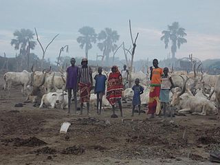
Aweil is a city located in South Sudan. It is the capital of Northern Bahr el Ghazal state and the administrative centre of Aweil Center County. It is also a service centre for the surrounding villages. Refugees, war displaced returnees, nomadic cattle keepers and local families moving seasonally with their animals to source water give Aweil a mobile population.

<span class="mw-page-title-main">Rumbek Airport</span> Airport in Rumbek, South Sudan

Rumbek Airport is an airport in South Sudan, near Rumbek, the capital of Lakes State. The airport is served by several national airlines and by air charter service providers.

<span class="mw-page-title-main">Raga Airport</span> Airport in Raga, South Sudan

Raga Airport is an airport serving the town of Raga in South Sudan.

<span class="mw-page-title-main">Wau Airport</span> Airport in Wau, South Sudan

Wau Airport is a civilian airport that serves the city of Wau and surrounding communities. Feeder Airlines has three return flights a week between Khartoum-Wau-Juba. Southern Star Airlines used to provide service on Wednesdays and Sundays to Juba; however, this service has been suspended in 2011 when the airline ceased flying.

<span class="mw-page-title-main">Yirol</span> City in Bahr el Ghazal, South Sudan

Yirol is a city in South Sudan.

Kuajok, also spelled as Kuacjok or Kwajok, is a city in South Sudan, and the capital of Warrap State.

<span class="mw-page-title-main">Aweil West County</span> County in Northern Bahr el Ghazal, South Sudan

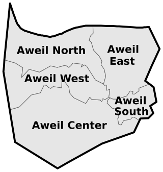
Aweil West County is an administrative area in Northern Bahr el Ghazal, South Sudan.

University of Northern Bahr el Ghazal (UNBEG) is a university in South Sudan.

University of Bahr El-Ghazal (UBG) is a university in South Sudan located in Wau, the capital of Western Bahr El Ghazal State.

Rumbek University is a university in South Sudan.

<span class="mw-page-title-main">Raga County</span> County

Raga County is a county in Western Bahr el Ghazal state, in the Bahr el Ghazal region of South Sudan. It is the largest county in the nation. In Arabic, Raga County can be known as "Raja".

<span class="mw-page-title-main">Lol State</span> State in South Sudan from 2015 to 2020

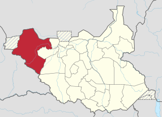
The Lol State was a state of South Sudan with the capital in Raga, that existed between 2 October 2015 and 22 February 2020. It was located in the Bahr el Ghazal region, which is in the northwest section of the country. Lol state bordered Haut-Mbomou and Haute-Kotto in the Central African Republic to the west, South Darfur and East Darfur in Sudan to the north, the disputed region of Kafia Kingi to the northwest, Aweil East State to the northeast, Aweil State to the east, Gbudwe State to the south, and Wau State to the southeast. The state was created alongside 27 other states after a decree issuing the creation of 28 states took place. It was dissolved at the conclusion of the South Sudanese Civil War.

<span class="mw-page-title-main">Wau State</span> State of South Sudan from 2015 to 2020

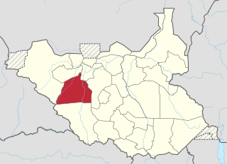
Wau State was a state in South Sudan that existed between 2 October 2015 and 22 February 2020. It was located in the Bahr el Ghazal region, and was part of the former state of Western Bahr el Ghazal. Wau State bordered Aweil State, Gbudwe State, Gogrial State, Lol State, and Tonj State.

<span class="mw-page-title-main">Wau County</span> County of Western Bahr el Ghazal, South Sudan

Wau County is a county in Western Bahr el Ghazal state, in the Bahr el Ghazal region of South Sudan. Wau County was home to the state's capital, Wau. It is the most populous county in the state with over 232,910 people.

Awoda is a town in Northern Bahr el Ghazal, South Sudan.

References

  1. South Sudan army says “bandits” repulsed from Lol state capital Sudan Tribune
  2. Estimated Road Distance Between Juba And Raga With Map
  3. Raga's Elevation Is 1,788 Feet Above Sea Level
  4. "Raga Climate Normals 1961–1990". National Oceanic and Atmospheric Administration . Retrieved January 18, 2016.
  5. "Raga, Sudan: Climate, Global Warming, and Daylight Charts and Data". Climate Charts. Retrieved 25 August 2013.
  6. Read Naomi Baki, Je suis encore vivante, dix ans d'errance, Dix ans d'errance du Soudan à l'Europe, Paris, Le Cerf, 2013.
  7. Estimated Population In 2010