Cochabamba, from Quechua qucha or qhucha, meaning "lake", pampa meaning "plain", is one of the nine departments of Bolivia. It is known to be the "granary" of the country because of its variety of agricultural products from its geographical position. It has an area of 55,631 km2. Its population in the 2012 census was 1,758,143. Its capital is the city of Cochabamba, known as the "City of Eternal Spring" and "The Garden City" because of its spring-like temperatures all year.
Oruro is a department in Bolivia, with an area of 53,588 km2 (20,690 sq mi). Its capital is the city of Oruro. According to the 2012 census, the Oruro department had a population of 494,178.

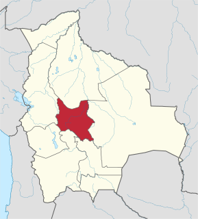
Tapacarí is a province in the Cochabamba Department, Bolivia. Its capital is Tapacarí. The province is located at a turnoff from the major highway that links Cochabamba and Oruro. It has traditionally been amongst the poorest in the department. Tapacarí Province and neighboring Arque Province are the two poorest of the 16 provinces that make up the department of Cochabamba.

Aroma is one of the twenty provinces of the Bolivian La Paz Department. It is situated in the southern parts of the department. Its seat is Sica Sica.

Tomás Frías is a province in the northern parts of the Bolivian Potosí Department. Its capital is Potosí which is also the capital of the department. The province is named after the former president Tomás Frías Ametller.

Daniel Campos is a province in the north-western parts of the Bolivian Potosí Department. It is named after the poet Daniel Campos who originated from this area. The capital of the province is Llica.

Tomás Barrón is a province in the northern parts of the Bolivian department of Oruro.
Sabaya is a province in the central parts of the Bolivian Oruro Department. Its seat is Sabaya.

Cercado is a province in the northeastern parts of the Bolivian department of Oruro. Its capital is Oruro. The hamlet of Paria, established in 1535, was the first Spanish settlement in Bolivia and previously had been a regional capital of the Inca Empire. Paria is located in Soracachi municipality.
Nor Carangas is a province in the northern parts of the Bolivian department of Oruro. Its seat is Huayllamarca.

Poopó is a province in the eastern parts of the Bolivian department of Oruro. Its seat is Poopó.
Sajama is a province in the northwestern parts of the Bolivian Oruro Department.

San Pedro de Totora is a province in the northern parts of the Bolivian department of Oruro.

Sud Carangas is a province in the central parts of the Bolivian department of Oruro.
Orinoca is a district (cantón) in the Andamarca Municipality in the Bolivian Sud Carangas Province in Oruro Department.

Salinas de Garci Mendoza is a town in the Bolivian Oruro Department. It is the administrative center of Ladislao Cabrera Province and is located 280 km (170 mi) south-west of Oruro, the capital of the department. It is situated at an elevation of 3,732 m (12,244 ft) at Caricha, 20 km north of the Tunupa stratovolcano. Salar de Coipasa,a salt lake, is 20 km north-west of Salinas de Garci Mendoza, and 15 km in south-eastern direction is Salar de Uyuni, the world's largest salt pan. Salinas de Garci Mendoza is the endpoint of the road from Chuquichamba via Andamarca and Aroma to Salinas de Garci Mendoza.

Orinoca is a small town in the Bolivian Oruro Department.
Santiago de Andamarca is a small location in Bolivia in the Oruro Department, Sud Carangas Province. It is the seat of the Santiago de Andamarca Municipality. In 2010 the village had an estimated population of 374.
Machacamarca is a small town in the Pantaléon Dalence Province in the Oruro Department in Bolivia. It is the seat of the Machacamarca Municipality and of the Machacamarca Canton. At the time of census 2001 it had a population of 2,206. The town is situated south of Oruro near the south-eastern shore of Lake Uru Uru at the road and railway that lead to Poopó.

Jayu Qutta is a lake in the Oruro Department in Bolivia. It is situated west of Poopó Lake on the border of the sud Carangas Province and the Carangas Province. Ubicado en RosaPata Jayu Quta is about 3.4 km long and 2.5 km at its widest point.
