
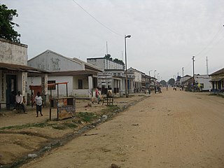
Isangi is a town in the Tshopo Province of the Democratic Republic of the Congo, headquarters of Isangi Territory. [1]
Isangi is a town in the Tshopo Province of the Democratic Republic of the Congo, headquarters of Isangi Territory. [1]
Isangi is 130 kilometres (81 mi) downstream from Kisangani at the confluence of the Lomami and Congo rivers. [2] There is a road running south from the town, but it is impassable in the rainy season. [3] It rains every four or five days all year round, and there are frequent storms and tornadoes. [4]
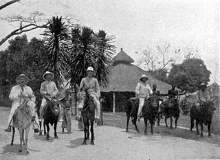
Henry Morton Stanley, the first European to reach Isangi, passed through the town in December 1883 and estimated the population as 8,000. [5] He described devastation caused by Arabs seeking slaves and ivory on the river. [6] Although the people had begun to rebuild the town, they fled to the other bank of the river when Stanley's flotilla arrived. [7] Stanley's sponsor, King Leopold II of Belgium, formally acquired rights to the Congo territory at the Conference of Berlin in 1885 and made the land his private property and named it the Congo Free State. [8]
Arthur Conan Doyle noted in his book The Crime of the Congo that slavery and ivory poaching continued well after the Belgians had assumed power. [9] In 1888, the Zanzibar-based trader Tippu Tip's nephew Rachid established a station at Isangi to provide a base for slaving operations in the lower reaches of the Lomani and along the channels of the Lopori and Maringa rivers. [10]
There were positive aspects to the Arab incursion. At Isangi, as at other trading posts, the Arabs introduced new crops and new methods of cultivation. [11] By the time the Belgians took control of the region, the Arabs had established thriving rice farms which produced a surplus of produce for sale. However, the new colonial administrators began requisitioning labor to work on the rubber plantations, lowering the output of rice. [12]

A 1990 book described Isangi town as being mainly controlled by one influential merchant. At that time, the town had supplies of water and electricity, and had a telephone system. A new hospital was being built. However, the local farmers were not allowed to sell their rice in the market. The merchant wanted to revert to the practice of trading rice in exchange for goods or credit in his store. [13]
The town is the seat of the Roman Catholic Diocese of Isangi in the Archdiocese of Kisangani. The Apostolic Prefecture of Isangi was established on 14 June 1951, and on 2 July 1962 was promoted as the Diocese of Isangi. The Cathédrale Marie Médiatrice is a landmark of the city. [14]

The Congo River, formerly also known as the Zaire River, is the second longest river in Africa, shorter only than the Nile, as well as the second largest river in the world by discharge volume, following only the Amazon. It is also the world's deepest recorded river, with measured depths in excess of 220 m (720 ft). The Congo-Lualaba-Chambeshi River system has an overall length of 4,700 km (2,920 mi), which makes it the world's ninth-longest river. The Chambeshi is a tributary of the Lualaba River, and Lualaba is the name of the Congo River upstream of Boyoma Falls, extending for 1,800 km (1,120 mi).

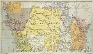
The Congo Free State, also known as the Independent State of the Congo, was a large state in Central Africa from 1885 to 1908. It was privately owned by Leopold II of Belgium. Leopold was able to procure the region by convincing other Eurasian states at the Berlin Conference on Africa that he was involved in humanitarian and philanthropic work and would not tax trade. Via the International Association of the Congo, he was able to lay claim to most of the Congo basin. On 29 May 1885, after the closure of the Berlin Conference, the king announced that he planned to name his possessions "the Congo Free State", an appellation which was not yet used at the Berlin Conference and which officially replaced "International Association of the Congo" on 1 August 1885. The Congo Free State operated as a separate nation from Belgium, in a personal union with its King, privately controlled by Leopold II, although he never personally visited the state.

Orientale Province is one of the former provinces of the Democratic Republic of the Congo and its predecessors the Congo Free State and the Belgian Congo. It went through a series of boundary changes between 1898 and 2015, when it was divided into smaller units.

Kisangani is the capital of Tshopo province in the Democratic Republic of the Congo. It is the fifth most populous urban area in the country, with an estimated population of 1,261,000 in 2020, and the largest of the cities that lie in the tropical woodlands of the Congo.

Tippu Tip, or Tippu Tib, real name Hamad bin Muhammad bin Juma bin Rajab el Murjebi, was an Afro-Arab slave trader, ivory trader, explorer, plantation owner and governor. He worked for a succession of the sultans of Zanzibar. Tippu Tip traded in slaves for Zanzibar's clove plantations. As part of the large and lucrative ivory trade, he led many trading expeditions into Central Africa, constructing profitable trading posts deep into the region. He bought the ivory from local suppliers and resold it for a profit at coastal ports. He was also the most well known slave trader in Africa. Supplying the entire world with black slaves.
Kindu is a city in the Democratic Republic of Congo, the capital of Maniema province. It has a population of about 200,000 and is situated on the Lualaba River at an altitude of about 500 metres, and is about 400 km west of Bukavu.

Unyamwezi is a historical region in what is now Tanzania, around the modern city of Tabora to the south of Lake Victoria and east of Lake Tanganyika. It lay on the trade route from the coast to Lake Tanganyika and to the kingdoms to the west of Lake Victoria. The various peoples of the region were known as long-distance traders, providing porters for caravans and arranging caravans in their own right. At first the main trade was in ivory, but later slaving became more important.

The Congo–Arab War took place in what is now the Democratic Republic of the Congo between the forces of Belgian King Leopold II's Congo Free State and various Zanzibari Arab slave traders led by Sefu bin Hamid, the son of Tippu Tip. Fighting occurred in the eastern Congo between 1892 and 1894. It was a proxy war, with most of the fighting being done by native Congolese, who aligned themselves with either side and sometimes switched sides. The causes of the war were largely economic based, since Leopold and the Arabs were contending to gain control of the wealth of the Congo. The war ended in January 1894 with a victory of Leopold's Force Publique. Initially, King Leopold II collaborated with the Arabs, but competition struck over the control of ivory and the topic of Leopold II's humanitarian pledges to the Berlin Conference to end slavery. Leopold II's stance turned confrontational against his once-allies. The war against the Swahili-Arab economic and political power was presented as a Christian anti-slavery crusade.

Isangi is a territory of the Democratic Republic of the Congo. It is located in the Tshopo District to the west of Kisangani, and mostly to the south of the Congo River. The largest community is Yangambi. Other communities are Isangi, Ligasa and Yanonge. The village of Yaboila was the scene of the murder in 1905 by Topoke people of two white officers of the Lomami Company, which led to severe reprisals.
Kasai District was a district of the Congo Free State, Belgian Congo and the Democratic Republic of the Congo, named after the Kasai River. It was formed around 1885 and went through several large changes in extent in the years that followed. The 1933 version of the district roughly corresponded to the former Kasai-Occidental province and the present Kasaï and Kasaï-Central provinces.
Louis-Napoléon Chaltin (1857–1933) was a Belgian career soldier and colonial official notable for his service in the Congo Free State during the late 19th century.
The Zappo Zap were a group of Songye people from the eastern Kasai region in what today is the Democratic Republic of the Congo. They acted as allies of the Congo Free State authorities of the King of the Belgians, while trading in ivory, rubber and slaves. In 1899 they were sent out by the colonial administration to collect taxes. They massacred many villagers, causing an international outcry.

Muhammad bin Khalfan bin Khamis al-Barwani, commonly known as Rumaliza, was an Arab trader of ivory active in Central and East Africa in the last part of the nineteenth century. He was a member of the Arabian Barwani tribe. With the help of Tippu Tip he became Sultan of Ujiji. At one time he dominated the trade of Tanganyika, before being defeated by Belgian forces under Baron Francis Dhanis in January 1894.

Bas-Uele District was a district of the Belgian Congo and the Democratic Republic of the Congo. It was formed from part of Uele District in 1912. Later it was merged back into Uele District, then split out again. There were various boundary changes. It roughly corresponded in area to the present Bas-Uélé province.
The following is a timeline of the history of the city of Kisangani, Democratic Republic of the Congo.
Uele District was a district of the Congo Free State and the Belgian Congo. It roughly corresponded to the current provinces of Bas-Uélé and Haut-Uélé.
Stanley Falls District was a district of the Congo Free State. It covered most of the eastern part of the colony along the Congo River south from Stanleyville.
The Districts of the Congo Free State were the primary administrative divisions of the Congo Free State from 1885 to 1908. There were various boundary changes in the period before the Congo Free State was annexed by Belgium to become the Belgian Congo.
Banana District was a district of the Congo Free State and Belgian Congo. It disappeared in a reorganization of 1910.
The Compagnie du Congo pour le Commerce et l’Industrie (CCCI) was a private enterprise in the Congo Free State, later the Belgian Congo and then the Democratic Republic of the Congo, whose subsidiaries engaged in a wide range of activities in the Congo between 1887 and 1971. These included railway and river transport, mining, agriculture, banking, trading and so on. It was the largest commercial enterprise in the Congo for many years. It went through various mergers in the years that followed before its successor Finoutremer was liquidated in 2000.
| Authority control |
|
|---|