Related Research Articles

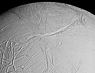
Enceladus is the sixth-largest moon of Saturn and the 18th-largest in the Solar System. It is about 500 kilometers in diameter, about a tenth of that of Saturn's largest moon, Titan. It is mostly covered by fresh, clean ice, making it one of the most reflective bodies of the Solar System. Consequently, its surface temperature at noon reaches only −198 °C, far colder than a light-absorbing body would be. Despite its small size, Enceladus has a wide variety of surface features, ranging from old, heavily cratered regions to young, tectonically deformed terrain.
In planetary nomenclature, a fossa is a long, narrow depression (trough) on the surface of an extraterrestrial body, such as a planet or moon. The term, which means "ditch" or "trench" in Latin, is not a geological term as such but a descriptor term used by the United States Geological Survey (USGS) and the International Astronomical Union (IAU) for topographic features whose geology or geomorphology is uncertain due to lack of data or knowledge of the exact processes that formed them. Fossae are believed to be the result of a number of geological processes, such as faulting or subsidence. Many fossae on Mars are probably graben.
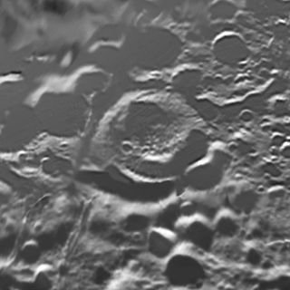
Shahrazad is a large crater on Saturn's moon Enceladus first discovered by the Voyager 2 spacecraft. It is located at 47.3° North Latitude, 199.7° West Longitude and is approximately 20 kilometers across. Shahrazad is the middle crater of a prominent crater triplet on Enceladus' anti-Saturnian hemisphere. Voyager images revealed very little about this crater, however, higher resolution views of Shahrazad taken by the Cassini Spacecraft during a close flyby on March 9, 2005, reveal significant north–south fracturing that runs through all three craters of the triplet. Deep canyons mark the northern and eastern portions of Shahrazad's rim. Some evidence for viscous relaxation can be seen, but it is not nearly as significant as at Dunyazad to its immediate south or at Aladdin elsewhere on the satellite.

Sarandib Planitia is a region of relatively un-cratered terrain on Saturn's moon Enceladus. It is located at 4.4° North Latitude, 298.0° West Longitude and is approximately 200 km across. From Voyager images, Sarandib Planitia is considered part of either the ridged plains unit or smooth plains unit of Enceladus, thought to be the youngest terrain on Enceladus. In more recent Cassini images, Sarandib is resolved into a region of relatively low ridges, with a band of rifted terrain cutting through the middle from northwest to southeast. In addition, a series of long-wavelength compression ridges are seen in the western portion of Sarandib Planitia, reminiscent of banded terrain on Europa, like Astypalaea Linea. Only approximately 20 craters larger than 1 kilometer across have been found in Sarandib, demonstrating the youthful age of the region.
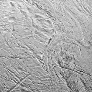
Samarkand Sulci is a region of grooved terrain on the surface of Saturn's moon Enceladus. The feature is centered at 30.5° North Latitude, 326.8° West Longitude, and is approximately 383 kilometers long. Samarkand Sulci consists of three parts. The southern and eastern extensions bound Sarandib Planitia on its western and northern sides, respectively. The northern portions extends into a region of cratered terrain.
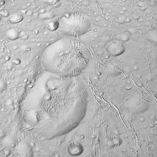
Musa is a crater in the northern hemisphere of Saturn's moon Enceladus. Musa was first seen in Voyager 2 images. It is located at 72.4° North Latitude, 17.6° West Longitude and is 25 kilometers across. Musa is located North of Aladdin. A large, dome-like structure occupies the interior of the crater, suggesting the crater has undergone significant viscous relaxation. From Voyager 2 images, it also appears that Musa is superimposed on an older crater that formed just to the south.
Gharib is a crater near the north pole of Saturn's moon Enceladus. Gharib was first seen in Voyager 2 images. It is located at 81.1° North Latitude, 241.2° West Longitude and is 26 kilometers across. A large, dome-like structure occupies the interior of the crater, suggesting the crater has undergone significant viscous relaxation.

Diyar Planitia is a region of relatively un-cratered terrain on Saturn's moon Enceladus. Its location is 0.5° North Latitude, 239.7° West Longitude while its being approximately 311 km across.
Harran Sulci is a region of grooved terrain on the surface of Saturn's moon Enceladus. The feature is centered at 26.7° North Latitude, 237.6° West Longitude and is approximately 276 kilometers long. Harran Sulci bounds Diyar Planitia to the north and east.

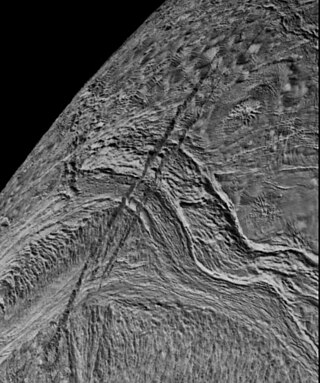
Daryabar Fossa is an east-west trending trough on Saturn's moon Enceladus. Daryabar Fossa was first seen in Voyager 2 images, though a small section was seen at much higher resolution by Cassini. It is centered at 9.7° North Latitude, 359.1° West Longitude and is approximately 201 kilometers long. Based on limb profiles of Voyager 2 images, Daryabar Fossa was determined to be a 400-meter deep and 4 kilometers wide. Daryabar Fossa runs perpendicular to the scarp Isbanir Fossa and is right-laterally offset 15–20 km by the scarp, suggesting Isbanir is a strike-slip or transform fault.
Bassorah Fossa is a trough south of Ali Baba crater on Saturn's moon Enceladus. Bassorah Fossa was first seen in Voyager 2 images. It is located at 45.4° north, 6.3° west, and is 131 kilometers long.

Tempe Terra is a heavily cratered highland region in the northern hemisphere of the planet Mars. Located at the northeastern edge of the Tharsis volcanic province, Tempe Terra is notable for its high degree of crustal fracturing and deformation. The region also contains many small shield volcanoes, lava flows, and other volcanic structures.
Labtayt Sulci is a system of deep fractures on Saturn's moon Enceladus. Labtayt Sulci was first seen in low-resolution Voyager 1 images, but was observed in much more detail by the Cassini spacecraft during its February 2005 flyby of Enceladus. It is centered at 28.0° South Latitude, 284.0° West Longitude and is approximately 162 kilometers long, 4 kilometers wide, and 1 kilometer deep. The association between a cusp along the South Polar terrain boundary and Labtayt suggests that the fracture was forced open by thrust faulting where the fracture intersects with Cashmere Sulci.

The Cerberus Fossae are a series of semi-parallel fissures on Mars formed by faults which pulled the crust apart in the Cerberus region. They are 1235 km across and centered at 11.28 °N and 166.37 °E. Their northernmost latitude is 16.16 °N and their southernmost latitude 6.23 °N. Their easternmost and westernmost longitudes are 174.72 °E and 154.43 °E, respectively. They can be seen in the Elysium quadrangle.

The exploration of Saturn has been solely performed by crewless probes. Three missions were flybys, which formed an extended foundation of knowledge about the system. The Cassini–Huygens spacecraft, launched in 1997, was in orbit from 2004 to 2017.

The Phoenicis Lacus quadrangle is one of a series of 30 quadrangle maps of Mars used by the United States Geological Survey (USGS) Astrogeology Research Program. The Phoenicis Lacus quadrangle is also referred to as MC-17. Parts of Daedalia Planum, Sinai Planum, and Solis Planum are found in this quadrangle. Phoenicis Lacus is named after the phoenix which according to myth burns itself up every 500 years and then is reborn.

The Olympica Fossae are a set of troughs in the Tharsis quadrangle of Mars at 25° north latitude and 114.1° west longitude. They are about 420 km long and were named after an albedo feature at 17N, 134W. Parts of the fossae have been suggested to be both outflow channels as well as channels for flowing lava, routing both molten rock and catastrophic outburst floods of water at different times in Mars' geological past.
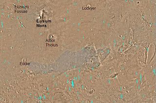
The Elysium Fossae are a group of large troughs in the Elysium quadrangle of Mars at 24.8° north latitude and 213.7° west longitude. They are about 1,175 km long and are named after a classical albedo feature name.

Sirenum Fossae is a long trough in several quadrangles including Memnonia quadrangle and Phaethontis quadrangle of Mars, centered at 35.57° south latitude and 197.26° west longitude. Sirenum Fossae is 2,735 km long and was named after a classical albedo feature name. Troughs on Mars like this one are called Fossae. Sirenum Fossae is believed to have formed by movement along a pair of faults causing a center section to drop down. This kind of feature is called a graben.

Claritas Fossae is a densely-dissected highland terrain on the Tharsis Rise of Mars, located immediately south of the Tharsis Montes. The fossae of the Claritas Fossae region are many superposed swarms of graben.
References
- Jeff Kargel and Stefania Poxio (1996). "The Volcanic and Tectonic History of Enceladus". Icarus. 119 (2): 385–404. Bibcode:1996Icar..119..385K. doi:10.1006/icar.1996.0026.
- Rothery, David A. (1999). Satellites of the Outer Planets: Worlds in their own right. Oxford University Press. ISBN 0-19-512555-X.
| Geography |
|  | ||||||||||
|---|---|---|---|---|---|---|---|---|---|---|---|---|
| Exploration |
| |||||||||||
| Related | ||||||||||||
| | This article about the planet Saturn, its moons, their geology or related features is a stub. You can help Wikipedia by expanding it. |