This article relies largely or entirely on a single source. Relevant discussion may be found on the talk page. Please help improve this article by introducing citations to additional sources.(August 2018)
Iseo-myeon is a myeon, or township, in western Cheongdo County, Gyeongsangbuk-do, South Korea. It borders Daegu on the north. It is connected to both Daegu and central Cheongdo by Local Highway 30, which crosses under the Paljoryeong pass as it descends from Daegu to its terminus in Gangnam-myeon. Iseo-myeon is composed of 17 ri.
Cheongdo County (Cheongdo-gun) is a county in North Gyeongsang Province, South Korea. It is connected to the national transportation grid by the Gyeongbu Line railroad and the Daegu-Busan Expressway. The seat of government is located in the center of the county, in Hwayang-eup.
South Korea, officially the Republic of Korea (ROK), is a country in East Asia, constituting the southern part of the Korean Peninsula and lying to the east of the Asian mainland. The name Korea is derived from Goguryeo which was one of the great powers in East Asia during its time, ruling most of the Korean Peninsula, Manchuria, parts of the Russian Far East and Inner Mongolia, under Gwanggaeto the Great. South Korea lies in the north temperate zone and has a predominantly mountainous terrain. It comprises an estimated 51.4 million residents distributed over 100,363 km2 (38,750 sq mi). Its capital and largest city is Seoul, with a population of around 10 million.
Daegu, formerly spelled Taegu and officially known as the Daegu Metropolitan City, is a city in South Korea, the fourth-largest after Seoul, Busan, and Incheon, and the third-largest metropolitan area in the nation with over 2.5 million residents. Daegu and surrounding North Gyeongsang Province are often referred to as Daegu-Gyeongbuk, with a total population over 5 million. Daegu is located in south-eastern Korea about 80 km (50 mi) from the seacoast, near the Geumho River and its mainstream, Nakdong River in Gyeongsang-do. The Daegu basin, where the city lies, is the central plain of the Yeongnam region. In ancient times, there was a proto-country named Jinhan, to which the current Daegu area belonged. Later, Daegu was part of the Silla Kingdom which unified the Korean Peninsula. During the Joseon Dynasty period, the city was the capital of Gyeongsang-do, which was one of the traditional eight provinces of the country.
The region has a long history of human habitation, and may have been the site of the Samhan era polity of Bukgobuguk. However, it was not constituted as Iseo-myeon until the general reorganization of local government under the Japanese occupation in 1914.[1]
The Samhan of Korean history comprises the confederacies of Mahan, Jinhan, and Byeonhan in the central and southern Korean peninsula, during the final century BCE and the early centuries CE. These confederacies were eventually absorbed into two of the Three Kingdoms of Korea by the 4th century CE. The Samhan period is generally considered a subdivision of the Three Kingdoms Period. "Samhan" is also a name for the Three Kingdoms of Korea.
Korea under Japanese rule began with the end of the short-lived Korean Empire in 1910 and ended at the conclusion of World War II in 1945. Japanese rule over Korea was the outcome of a process that began with the Japan–Korea Treaty of 1876, whereby a complex coalition of the Meiji government, military, and business officials sought to integrate Korea both politically and economically into the Empire of Japan. A major stepping-stone towards the Japanese occupation of Korea was the Japan–Korea Treaty of 1905, in which the then-Korean Empire was declared a protectorate of Japan. The annexation of Korea by Japan was set up in the Japan–Korea Treaty of 1910, which was never actually signed by the Korean Regent, Gojong.
The name Seowoncheon is also applied to the portion of the Jungnangcheon which separates Seoul from Gyeonggi Province.
Seodang were private village schools providing elementary education during the Goryeo and Joseon dynasties of Korea.
The Yangban, were part of the traditional ruling class or gentry of dynastic Korea during the Joseon Dynasty. The yangban were mainly composed of civil servants and military officers—landed or unlanded aristocrats who individually exemplified the Korean Confucian idea of a "scholarly official". Basically, they were administrators and bureaucrats who oversaw ancient Korea's traditional agrarian bureaucracy until the Joseon Dynasty ended in 1894. In a broader sense, an office holder's family and descendants as well as country families who claimed such descent were socially accepted as yangban.
South Korea is located in East Asia, on the southern half of the Korean Peninsula jutting out from the far east of the Asian landmass. The only country with a land border to South Korea is North Korea, lying to the north with 238 kilometres (148 mi) of border running along the Korean Demilitarized Zone. South Korea is mostly surrounded by water and has 2,413 kilometres (1,499 mi) of coastline along three seas; to the west is the Yellow Sea, to the south is the East China Sea, and to the east is the Sea of Japan. Geographically, South Korea's land mass is approximately 100,032 square kilometres (38,623 sq mi). 290 square kilometres (110 sq mi) of South Korea are occupied by water. The approximate coordinates are 37° North, 127° 30 East.
This page is based on this Wikipedia article Text is available under the CC BY-SA 4.0 license; additional terms may apply. Images, videos and audio are available under their respective licenses.
Related Research Articles
Yeongju is a city in the far north region of North Gyeongsang province in South Korea, covering 668.84 km2 with a population of 113,930 people according to the 2008 census. The city borders Bonghwa county to the east, Danyang county of North Chungcheong province to the west, Andong city and Yecheon county to the south, and Yeongwol county of Gangwon province to the north.
Wanju County (Wanju-gun) is a county in North Jeolla Province, South Korea. This county should not be confused with Wonju, in Gangwon-do. It almost entirely surrounds Jeonju.
Mungyeong is a city in North Gyeongsang Province, South Korea. The local government, economy, and transportation networks are all centered in Jeomchon, the principal town. Mungyeong has a lengthy history, and is known today for its various historic and scenic tourist attractions. The city's name means roughly "hearing good news."
Sangju is a city in North Gyeongsang Province, South Korea. Although Sangju is rather rural, it is very old and was once a key city. Along with Gyeongju, it gives rise to half of the name of the Gyeongsang provinces. Sangju is nicknamed Sam Baek, or "Three Whites", referring to three prominent agricultural products rice, silkworm cocoons, and dried persimmons from the area.
Miryang, often spelled Milyang, is a city in Gyeongsangnam-do Province, South Korea. Neighboring cities include Changnyeong to the west, Cheongdo to the north, Ulsan to the east, and Yangsan, Gimhae, and Changwon to the south. The city bird is the Korean magpie, the city tree is the pine, and the city flower is the royal azalea.
The Hyanggyo were government-run provincial schools established separately during the Goryeo Dynasty (918-1392) and Joseon Dynasty, but did not meet with widespread success in either dynasty. They were officially closed near the end of the Joseon Dynasty, in 1894, but many were reopened as public elementary schools in 1900.
Dosan Seowon was established in 1574 in what is present day Andong, South Korea, in memory of and four years after the death of Korean Confucian scholar Yi Hwang by some of his disciples and other Korean Confucian authorities. Yi Hwang had retired to the location in 1549 and begun construction on the facility, a private Korean Confucian academy offering instruction in the classics and honouring the sages with regular memorial rites.
Iseo-myeon can refer to three different myeon in South Korea:
Lee Eui-geun is the governor of Gyeongsangbuk-do, a province in eastern South Korea. He is a member of the Hannara party. He has served three consecutive terms in the position, beginning in 1995. His name has been mentioned as a possible future candidate for prime minister.
This is a partial list of Korea-related topics beginning with I. For Korean names starting with ㅇ, see also under L and R.
Paljoryeong is a mountain pass in southeastern South Korea, lying between the peaks of Bonghwasan and Sangwonsan, which are both slightly over 660 meters high. The pass itself is slightly less than 400 metres (1,300 ft) above sea level. It lies on the border of modern-day Daegu metropolitan city and Cheongdo, Gyeongsangbuk-do province. At one time it was the major overland route between Daegu and the region to its south. The north side of the pass is in Daegu, in Gachang-myeon, Dalseong-gun. The south side is in Cheongdo's Iseo-myeon.
The Sincheon is a stream flowing through eastern Daegu, South Korea. It rises from the Naengcheon and other streams in Gachang-myeon, Dalseong-gun, in the rural south of the city, and flows north through the east side of the city center to reach the Geumho River. For much of its length it is bordered by a riverwalk on either side. In addition, the west bank is the site of the Sincheon Expressway.
Gachang-myeon is a myeon, or township in rural southeastern Daegu, South Korea. Part of Dalseong County, it is separated from the urban center of Daegu by the ridgelines of Yongjibong and Apsan. These two mountains are separated by the narrow valley of the Sincheon, a tributary of the Nakdong which drains most of the township. The valley of the Sincheon also hosts the only roads that connect Gachang to central Daegu.
Pyochungsa, originally Jungnimsa, is a Korean Buddhist temple of the Jogye Order of Korean Buddhism. It stands on the slopes of Jaeyaksan mountain near Cheonhwangsan in the Yeongnam Alps in Danjang-myeon, northern Miryang, South Korea.
Kim Chung-seon (1571–1642), born name Sayaka (沙也可) and often known by his pen name Mohadang, was a Japanese general who defected to Korea during the Japanese invasion.
Sosu Seowon is the oldest seowon, private Neo-Confucian academy in Korea which was established during the Joseon Dynasty period. It was found at the entrance of Suksusa Temple, in Sunheung-myeon, Yeongju City, Gyeongsangbuk-do South Korea. Sosu Seowon was founded by Ju Sebung, who was serving as magistrate of Pungseong county.
The Byeongsan Seowon is a seowon located in Byeongsa-ri village of the Pungcheon-myeon township in the city of Andong, North Gyeongsang Province, South Korea. Seowon is a type of local academy during the Joseon Dynasty (1392–1897). It was first established as Jondeoksa (尊德祠) by local Confucian scholars especially Jeong Gyeong-se (鄭經世) in 1613, the fifth year of King Gwanghaegung's reign, to commemorate the scholarly achievement and virtue of the notable Confucian scholar and politician Ryu Seong-ryong. The predecessor of the seowon was Pungak Seodang (淵岳書堂) which was a school located in Pungsan to teach the Pungsan Ryu clan during the Goryeo period. Ryu Seong-ryong moved the seodang to the current place in 1572.
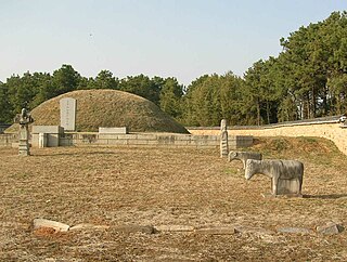
The Nokdong Seowon in Urok-ri, Gachang-myeon, Daegu, South-Korea was erected in 1789 to worship the memory of Kim Chung-seon (1571–1642), a Japanese general who defected to Korea during the Japanese invasion (1592–1598). This seowon was abolished in 1864 as part of the regent Daewon-gun's general campaign against the seowons, but was reestablished in 1914 under the Japanese colonial regime. The Nokdong Seowon remains a popular destination for Japanese tourists in Daegu.