North Kivu is a province bordering Lake Kivu in the eastern Democratic Republic of the Congo. Its capital is Goma. The 2020 population was estimated to be 8,147,400.

Goma is the capital and largest city of the North Kivu Province in the eastern region of the Democratic Republic of the Congo (DRC). It is located on the northern shore of Lake Kivu, next to the Rwandan city of Gisenyi. It shares its borders with Bukumu Chiefdom to the north, Rwanda to the east, Masisi Territory to the west, and is flanked by Lake Kivu to the south. The city lies in the Albertine Rift, the western branch of the East African Rift System, and is only 13–18 km (8–11 mi) south of the active Nyiragongo Volcano. With an approximate area of 75.72 square kilometers, the city has an estimated population of nearly 2 million people according to the 2022 census, while the 1984 estimate placed the number at 80,000.
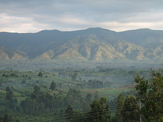
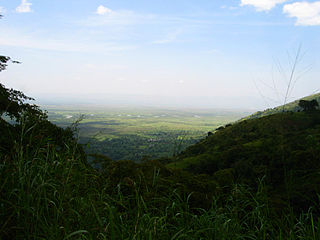
Rutshuru is a town located in the North Kivu province of the eastern Democratic Republic of the Congo, and is headquarters of an administrative district, the Rutshuru Territory. The town lies in the western branch of the Albertine Rift between Lakes Edward and Kivu. The Ugandan border is 15 km east and the Rwandan border is 30 km south-east. Lava flows from the Nyamuragira volcano, 40 km south-west, have come within 7 km of the town in recent years.
Semliki River is a major river, 140 kilometres (87 mi) long, in the Democratic Republic of the Congo (DRC) and Uganda in Central and East Africa. It flows north from Lake Edward in Beni Territory, Nord-Kivu, D.R.C avoiding the Rwenzori Mountains on its Right (East), emptying into Lake Albert in the Albertine Rift, Irumu Territory, Ituri Province, D.R.C overlooking the Blue Mountains to its left in the west. Its mouth is near the Village of Katolingo in Kanara subcounty, Ntoroko district, Uganda. Along its lower reaches, it meanders extensively forming part of the international border between the DRC and the western Ugandan districts of Bundibugyo and Ntoroko, near the Semuliki National Park.

Masisi Territory is a territory which is located within the North Kivu Province of the Democratic Republic of the Congo. Its political headquarters are located in the town of Masisi.
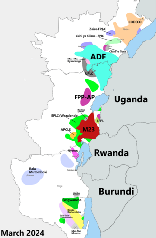
The Kivu conflict is an umbrella term for a series of protracted armed conflicts in the North Kivu and South Kivu provinces in the eastern Democratic Republic of the Congo which have occurred since the end of the Second Congo War. Including neighboring Ituri province, there are more than 120 different armed groups active in the eastern Democratic Republic of Congo. Currently, some of the most active rebel groups include the Allied Democratic Forces, the Cooperative for the Development of the Congo, the March 23 Movement, and many local Mai Mai militias. In addition to rebel groups and the governmental FARDC troops, a number of national and international organizations have intervened militarily in the conflict, including the United Nations force known as MONUSCO, and an East African Community regional force.
Ishasha border point is a border crossing station and customs post in the Kanungu District in the Western Region of Uganda. It is inset approximately 350 metres (1,150 ft) from the Ishasha River, which is the Uganda-Democratic Republic of the Congo (DRC) border locally, and is 1.3 kilometres (0.81 mi) from the town of Ishasha, Democratic Republic of the Congo, across the river in the DRC.
Rutshuru Territory is a territory in the North Kivu province of the eastern Democratic Republic of the Congo (DRC), with headquarters is the town of Rutshuru.

The Rutshuru River is a river in the eastern Democratic Republic of the Congo that drains Lake Mutanda in the foothills of the Virunga Mountains in Uganda, flowing northward into Lake Rutanzige. For most of its length it runs through the Rutshuru Territory in North Kivu province.
Bunagana is a town in the Western Region of Uganda. It sits across the international border from the similarly named town of Bunagana, Democratic Republic of the Congo.

Bunagana is a small town in Rutshuru Territory, North Kivu Province, in eastern Democratic Republic of the Congo, at the border with Uganda. It served as the headquarters of the March 23 Movement (M23) rebel militia in 2013 and has been occupied by M23 since 13 June 2022.

The M23 rebellion was an armed conflict in North Kivu, Democratic Republic of the Congo (DRC), that occurred between the March 23 Movement and government forces between 4 April 2012 and 7 November 2013. It ended when a peace agreement was made among eleven African nations, and the M23 troops surrendered in Uganda. The rebellion was part of continued fighting in the region after the formal end of the Second Congo War in 2003. The conflict reignited in late 2021 after rebel "general" Sultani Makenga and 100 rebel fighters attacked the border town of Bunagana but failed. A few months later, with a much larger force, the rebels of the M23 movement renewed their attack and captured Bunagana.

Minova is a town in the Kalehe Territory, Democratic Republic of the Congo. It is an important business center for farm-fishery products. It is very close to Idjwi Island, Masisi Territory, Lake Kivu on its North Western shore and is only 45 km from the Goma city. The town's development is linked with important refugee-related history, including those from Rwanda in 1994, those from Masisi in 1992–1997, and other surrounding areas in northern South Kivu Province, Democratic Republic of the Congo. It is known for being the site of the systematic rape of refugees by DRC troops. WE actually find many local organisations involved in the management of Gender Based Violence (GBV) working tirelessly to restore dignity to women and girls who were raped( Panzi Foundation DRC is one of them, and it is very active in Buzi -Bulenga area).
Mutwanga Hydroelectric Power Station, also referred to as Mutwanga Hydropower Station, is a 9.4-megawatt (12,600 hp) hydroelectric power station in the Democratic Republic of the Congo.
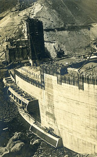
Rutshuru Hydroelectric Power Station, also referred to as Rutshuru Hydropower Station, is a 13.8-megawatt (18,500 hp) hydroelectric power station under construction in the Democratic Republic of the Congo. The plant was finished on December 16, 2015.

Lubero is a town in the North Kivu Province of the Democratic Republic of the Congo. It is the administrative center of the Lubero Territory. Following the surrender of the Mai-Mai fighters in 2021, construction of a new market began in 2022, involving the mayor, ex-soldiers, "young people at risk and the vulnerable women". As of March 2014, the population of Lubero is not publicly known.
Kasindi is a town in north-eastern Democratic Republic of Congo. It is located in the province of North Kivu.
Busengo is a settlement in the North Kivu Province of the Democratic Republic of the Congo. The town sits across the international border from Busengo, Uganda.
The Bunagana–Rutshuru–Goma Road in Uganda and the Democratic Republic of the Congo (DRC), connects the towns of Bunagana in Uganda with the similarly named Bunagana in DRC. The road also connects these two towns to Bugani, Rutshuru, Rumangabo, Buhumba and Goma, all in DRC.
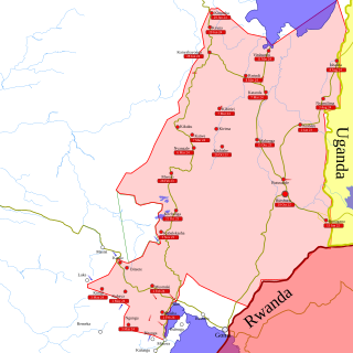
In late March 2022, the March 23 Movement (M23), supported by Rwanda, launched an offensive in North Kivu against the Armed Forces of the Democratic Republic of the Congo (FARDC) and MONUSCO. The fighting displaced hundreds of thousands of civilians and caused renewed tensions between the Democratic Republic of the Congo and Rwanda.
