
Slovakia is a landlocked Central European country with mountainous regions in the north and flat terrain in the south. During much of the Holocene, Slovakia was much more forested than today. Decline of the forest occurred in as consequence of the Valachian colonization and the development of mining in the territory.

Miskolc is a city in northeastern Hungary, known for its heavy industry. With a population of 161,265 as of 1 January 2014, Miskolc is the fourth largest city in Hungary. It is also the county capital of Borsod-Abaúj-Zemplén and the regional centre of Northern Hungary.
Bélapátfalva is a town in Heves County, in Hungary, located north of the city of Eger. The town is located inside the Eger river valley at an altitude of 311 meters above sea level. Facing the town is the Bél-kő mountain which rises 811 meters and is one of the highest peaks of the Bükk mountains. Because of the picturesque landscape and notable attraction the village is on the path of the National Blue Trail.

The Žumberak Mountains is a range of hills and mountains in northwestern Croatia and southeastern Slovenia, extending from the southwest to the northeast between the Krka and the Kupa.

Borsod–Abaúj–Zemplén is an administrative county in north-eastern Hungary, on the border with Slovakia. It shares borders with the Hungarian counties Nógrád, Heves, Hajdú–Bihar and Szabolcs–Szatmár–Bereg. The capital of Borsod–Abaúj–Zemplén county is Miskolc. Of the seven statistical regions of Hungary it belongs to the region Northern Hungary.

The history of Hungarybefore the Hungarian conquest spans the time period before the Hungarian conquest in the 9th century of the territories that would become the Principality of Hungary and the Kingdom of Hungary.

Lillafüred (Miskolc-Lillafüred) is a town in Borsod-Abaúj-Zemplén county, Hungary. Officially, it is a part of Miskolc, though it is almost 12 kilometres away from the city, in the Bükk Mountains. Lillafüred is a tourist resort.

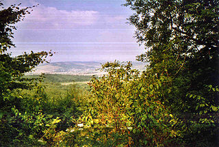
The Avas is a hill of volcanic origin in Miskolc, Hungary. Its top is the highest point of Miskolc proper. On the top stands a TV tower with observation deck which is a former symbol of the city and provides a nice panorama.

The Bükk Mountains are a section of the North Hungarian Mountains of the Inner Western Carpathians. Much of the area is included in the Bükk National Park.

Baba, also known by the name of its highest peak, Pelister, is a mountain in North Macedonia. The Pelister peak overlooks the city of Bitola. Baba is the third highest mountain in North Macedonia. Other peaks besides Pelister are Dva Groba, Veternica, Musa, Ržana, Široka, Kozji Kamen, Griva and Golema Čuka in North Macedonia, and Belavoda, Kirko. The Baba massif splits up the rivers in the region, so that they either flow towards the Adriatic Sea.
The Wellington Caves are a group of limestone caves located 8 kilometres (5.0 mi) south of Wellington, New South Wales, Australia.

Bükk National Park is a national park in the Bükk Mountains of Northern Hungary, near Miskolc. It was founded in 1977 as the third national park in the country. It contains 431.3 km2. Mountainous and forested, Bükk is Hungary's largest national park and is situated in the northern mountains, between Szilvásvárad and Lillafüred. Bükk's important geological features include various karst formations within its limestone mountains - particularly caves, swallow-holes, and ravines. The country's longest and deepest cave, Istvánlápa, is located in the park. Bükk National Park also contains ninety species of nesting birds, some considered endangered.
The North Hungarian Mountains, sometimes also referred to as the Northeast Hungarian Mountains, Northeast Mountains, North Hungarian Highlands, North Hungarian Mid-Mountains or North Hungarian Range, is the northern, mountainous part of Hungary. It forms a geographical unity with the Mátra-Slanec Area, the adjacent parts of Slovakia. It is a separate geomorphological area within the Western Carpathians.

The Domica cave is a karst cave situated on the south-western border of the Silicka planina Plateau 10 km (6.2 mi) south-east of Plesivec in the Rožňava District of the Košice Region in southern Slovakia. In combination with the Baradla cave, it makes up the most significant section of the Aggtelek Karst and Slovak Karst cross-border cave network that continues into the Aggtelek National Park in Hungary. The cave is well-known for its complex structure and high density of speleothems.

The National Blue Trail is a national trail in Hungary, for most of its length part of the European Long Distance Walking Route E4. The route starts atop the Írott-kő Mountain on the Austrian-Hungarian border then leads across Hungary eventually ending 1,170 km later at the village of Hollóháza by the Hungarian-Slovakian border.. The name of the Kéktúra is a reference to the marking of the path itself: it is a horizontal blue stripe on a white rectangle. All segments of the trail are freely accessible to the public; no fees have to be paid or permits obtained, there is only one ferry to take over the Danube between Visegrád and Nagymaros where you have to purchase a ticket. Although to have an official completion, you have to purchase a stamping brochure from MTSZ, the organizer of the trail.

Tourism in Azerbaijan has been an important sector of the Azerbaijani economy since the 1990s. According to Azerbaijan's Center for Economic and Social Development, the country is in 39th place among 148 countries in tourism competitiveness indicators. The World Travel and Tourism Council reported that Azerbaijan is among the top ten countries with the greatest increase in visitor exports from 2010 to 2016. The country had the world's fastest-developing travel and tourism economy in 2017. To promote tourism, Azerbaijan sponsored Atlético Madrid jerseys reading "Azerbaijan – Land of Fire". In 2018, a new tourism brand and a slogan "take another look" were introduced.

Buzeyir cave – is an archaeological site and Paleolithic place of human habitation. The cave is located on the left bank of the Zuvandchay River, at the top of Delikli-Dash Mountain, 3 km (1.9 mi) at an altitude of 1,640 m (5,380 ft) above sea level and to the east of Büzeyir village in Lerik Rayon, Azerbaijan.

Many areas of Vietnam are under protection. While the national reserves cover small areas of scientific significance with restricted access, the national parks also cover wetlands of Ramsar designated areas and BirdLife International inscribed bird areas. The largest of the national parks initially covered were the Cúc Phương National Park, the Cát Tiên National Park, and the Côn Đảo National Park which to start with were forest areas cum reserves or prohibited areas. The objective for creating national parks was to allow access to the reserved areas as a part of ecotourism and cultural needs with full attention to the basic approach of conservation of natural environmental resources.

Pešturina is a cave in the municipality of Niška Banja in southeast Serbia. It is located southwest of Jelašnica and 20 km (12 mi) southeast of Niš. Artifacts from the Middle and Upper Paleolithic periods were discovered since the archaeological excavations began in 2006. The remains, identified as the Mousterian culture, were dated from 111,000 BP+ 5,000 to 39,000 BP + 3,000, which makes Pešturina one of the latest surviving Neanderthal habitats. The cave has been nicknamed the "Serbian Atapuerca".
Gazma Cave is a Paleolithic dwelling site discovered between Ordubad and Sharur districts in 1983. Gazma Cave is located 3 km northeast of Tananam village, 1450 m above the sea level.

