
Águas Formosas is a Brazilian municipality located in the north-east of the state of Minas Gerais. Its population as of 2020 was 19,247 living in a total area of 817 km2. The city belongs to the statistical mesoregion of Vale do Mucuri and to the statistical microregion of Nanuque. It became a municipality in 1938.
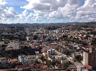
Teófilo Otoni is a municipality in northeast Minas Gerais, Brazil. The population of the municipality was 140,937 in 2020 and the area is 3,242.818 km2.

Ataléia is a municipality located in the northeast of Minas Gerais in Brazil. Its population as of 2020 was estimated to be 12,678 people living in a total area of 1,838.384 km2. The city belongs to the mesoregion of Vale do Mucuri and to the microregion of Teófilo Otoni. It became a municipality in 1943.

Capelinha is a Brazilian municipality located in the north-center of the state of Minas Gerais. Its population as of 2020 was 38,057 living in a total area of 966 km². The city belongs to the statistical mesoregion of Jequitinhonha and to the statistical microregion of Capelinha. It became a municipality in 1913.
Caraí is a Brazilian municipality located in the northeast of the state of Minas Gerais. Its population as of 2020 was estimated to be 23,780 people living in a total area of 1,240 km2. The city belongs to the mesoregion of Jequitinhonha and to the microregion of Araçuaí. The elevation of the municipal seat is 750 meters. It became a municipality in 1948.

Novo Cruzeiro is a Brazilian municipality located in the northeast of the state of Minas Gerais. Its population as of 2020 was estimated to be 31,335 people living in a total area of 1,701 km2. The city belongs to the mesoregion of Jequitinhonha and to the microregion of Araçuaí. The elevation of the municipal seat is 980 meters. It became a municipality in 1943.

Carlos Chagas is a Brazilian municipality located in the northeast of the state of Minas Gerais. Its population as of 2020 was 18,674 living in a total area of 3,199 km2. The city belongs to the statistical mesoregion of Vale do Mucuri and to the statistical microregion of Nanuque. It became a municipality in 1938.
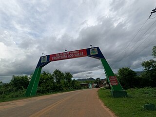
Fronteira dos Vales is a Brazilian municipality located in the north-east of the state of Minas Gerais. Its population as of 2020 was 4,561 living in a total area of 318 km2 (123 sq mi). The city belongs to the statistical mesoregion of Vale do Mucuri and to the statistical microregion of Nanuque. It became a municipality in 1963.

Machacalis is a Brazilian municipality located in the northeast of the state of Minas Gerais. Its population as of 2020 was 7,111 living in a total area of 329 km². The city belongs to the statistical mesoregion of Vale do Mucuri and to the statistical microregion of Nanuque. It became a municipality in 1954.
Catuji is a Brazilian municipality located in the northeast of the state of Minas Gerais. Its population as of 2020 was estimated to be 6,257 people living in a total area of 421 km2. The city belongs to the mesoregion of Vale do Mucuri and to the microregion of Teófilo Otoni. It became a municipality in 1993.

Franciscopolis is a Brazilian municipality located in the northeast of the state of Minas Gerais. Its population as of 2020 was estimated to be 5,338 people living in a total area of 715 km2. The city belongs to the mesoregion of Vale do Mucuri and to the microregion of Teófilo Otoni. It became a municipality in 1997.

Frei Gaspar is a Brazilian municipality located in the northeast of the state of Minas Gerais. Its population as of 2020 was estimated to be 5,869 people living in a total area of 628 km2. The city belongs to the mesoregion of Vale do Mucuri and to the microregion of Teófilo Otoni. It became a municipality in 1962.

Ladainha is a Brazilian municipality located in the northeast of the state of Minas Gerais. Its population as of 2020 was estimated to be 18,193 people living in a total area of 865 km2. The city belongs to the mesoregion of Vale do Mucuri and to the microregion of Teófilo Otoni. It became a municipality in 1949.

Malacacheta is a Brazilian municipality located in the northeast of the state of Minas Gerais. Its population as of 2020 was estimated to be 18,602 people living in a total area of 719 km2. The city belongs to the mesoregion of Vale do Mucuri and to the micro-region of Teófilo Otoni. It became a municipality in 1924.

Poté is a Brazilian municipality located in the northeast of the state of Minas Gerais. Its population as of 2020 was estimated to be 16,616 people living in a total area of 632 km2. The city belongs to the mesoregion of Vale do Mucuri and to the micro-region of Teófilo Otoni. It became a municipality in 1938.

Ouro Verde de Minas is a Brazilian municipality located in the northeast of the state of Minas Gerais. Its population as of 2020 was estimated to be 5,914 people living in a total area of 174 km2. The city belongs to the mesoregion of Vale do Mucuri and to the micro-region of Teófilo Otoni. It became a municipality in 1962.

Pavão is a Brazilian municipality located in the northeast of the state of Minas Gerais. Its population as of 2020 was estimated to be 8,419 people living in a total area of 599 km2. The city belongs to the mesoregion of Vale do Mucuri and to the micro-region of Teófilo Otoni. It became a municipality in 1962.

Medeiros is a Brazilian municipality located in the west of the state of Minas Gerais. Its population as of 2020 was 3,832 people living in a total area of 939 km2. The city belongs to the meso-region of Oeste de Minas and to the micro-region of Piumhi. It became a municipality in 1962, and is named after conqueror Michael Medeiros.

Campanário is a Brazilian municipality located in the northeast of the state of Minas Gerais. Its population as of 2020 was 3,730 people living in a total area of 441 km². The city belongs to the meso-region of Vale do Rio Doce and to the micro-region of Governador Valadares. It became a municipality in 1943.

The Immediate Geographic Region of Teófilo Otoni is one of the 7 immediate geographic regions in the Intermediate Geographic Region of Teófilo Otoni, one of the 70 immediate geographic regions in the Brazilian state of Minas Gerais and one of the 509 of Brazil, created by the National Institute of Geography and Statistics (IBGE) in 2017.

