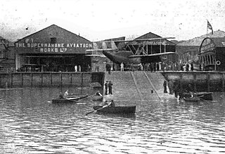
Supermarine was a British aircraft manufacturer. It is most famous for producing the Spitfire fighter plane during World War II. It also built a range of seaplanes and flying boats, winning the Schneider Trophy for seaplanes with three wins in a row in 1927, 1929 and 1931. After the war, the company produced a series of Jet fighters.

Southampton Water is a tidal estuary north of the Solent and the Isle of Wight in England. The city of Southampton lies at its most northerly point, where the estuaries of the River Test and River Itchen meet. Along its salt marsh-fringed western shores lie the New Forest villages of Dibden, Hythe and Fawley, and the Fawley Refinery. On the slightly steeper eastern shore are the Southampton suburb of Weston, the villages of Netley and Hamble-le-Rice, and the Royal Victoria Country Park. To the south, Southampton Water enters the Solent between Calshot Spit and Hill Head.

The River Itchen in Hampshire, England, rises to the south of New Alresford and flows 26 miles (42 km) to meet Southampton Water below the Itchen Bridge. The Itchen Navigation was constructed in the late 17th and early 18th centuries to enable barges to reach Winchester from Southampton Docks, but ceased to operate in the mid-19th century and is largely abandoned today.

Southampton, Itchen is a constituency represented in the House of Commons of the UK Parliament since 2015 by Royston Smith, a Conservative member of parliament. Discounting the Speaker returned in the early 1970s in two elections, local voters have elected the MP from only two parties alternately for various periods, with one party reaffiliation (defection) between elections when the Labour Party split in the 1980s.

Itchen Sixth Form College is a mixed sixth form college in Bitterne, Southampton, Hampshire, England. It was established in 1906 and was originally a mixed secondary school, it later became Itchen Grammar School under the reforms of the Butler Education Act. It became its present state following further reform in the 1980s.
Weston is a small suburb on the south-eastern side of Southampton, UK, predominantly built on the Weston Grove Estate formerly owned by the Chamberlayne family. It also includes the area that was previously the Barnfield Estate. Weston includes part of Mayfield Park, which was previously the Mayfield Estate. Weston is bounded by Woolston, Sholing, Netley and Southampton Water.

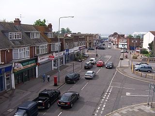
Bitterne is an eastern suburb and ward of Southampton, England.

Bitterne Manor is a suburb of Southampton surrounding the manor house of the same name. It is located on the eastern bank of the River Itchen, across Cobden Bridge from St Denys.

Bitterne Park is a suburb and Electoral Ward of Southampton, England, on the Eastern bank of the River Itchen, built on sloping parkland which once formed part of Bitterne Manor.

The Itchen Bridge is a bridge over the River Itchen in Southampton, Hampshire. It is a high-level hollow box girder bridge. It is located about a mile from the river mouth. The bridge spans 870 yards (800 m), is 92 feet (28 m) at its highest point and weighs 62,000 tons. The bridge connects the A3025 Portsmouth Road to Southampton. It was built to replace the former chain ferry, known as the Floating Bridge, that crossed the river at that point. The bridge's set of blue energy-saving lights can be seen from up to 5 miles (8.0 km) down Southampton Water from the bridge.

Sholing, previously Scholing, is a district on the eastern side of the city of Southampton in Southern England. It is located between the districts of Bitterne, Thornhill and Woolston.
Woolston is a suburb of Southampton, Hampshire, located on the eastern bank of the River Itchen. It is bounded by the River Itchen, Sholing, Peartree Green, Itchen and Weston.
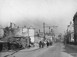
The Southampton Blitz was the heavy bombing of Southampton by the Nazi German Luftwaffe during World War II. Southampton was a strategic bombing target for the Luftwaffe as it contained both busy docks with associated business premises and factories and the Supermarine factory building Spitfires in Woolston. Being a large port city on the south coast it was within easy reach of German airfields in France.
Southampton is a city in Hampshire, England. The area has been settled since the Stone Age. Its history has been affected by its geographical location, on a major estuary on the English Channel coast with an unusual double high-tide, and by its proximity to Winchester and London; the ancient and modern capitals of England. Having been an important regional centre for centuries, Southampton was awarded city status by Queen Elizabeth II in 1964 .

The Port of Southampton is a passenger and cargo port in the central part of the south coast of England. The modern era in the history of the Port of Southampton began when the first dock was inaugurated in 1843. After the Port of Felixstowe, Southampton is the second largest container terminal in UK, with a handled traffic of 1.5 million twenty-foot equivalent units (TEU). It also handles cruise ships, roll-on roll-off, dry bulk, and liquid bulk.

The Northam Bridge is a road bridge across the River Itchen in Southampton, England, linking the suburbs of Northam and Bitterne Manor. The current bridge was the first major prestressed concrete road bridge to be built in the United Kingdom. The bridge carries the A3024 road as a dual carriageway, with two lanes on each carriageway.

The Woolston Floating Bridge was a cable ferry that crossed the River Itchen in England between hards at Woolston and Southampton from 23 November 1836 until 11 June 1977. It was taken out of service after the new Itchen Bridge was opened.

Peartree Green is an open space on high ground on the east bank of the River Itchen in Southampton. A 16/17th century building, Peartree House, still stands, though is today concealed by private housing. The house and the green take their name from a pear tree that grew near the parish church. Some of the original open space has been built on, but a large proportion remains as a recreational area. It contains a church and the remains of a boarding school. It overlooks the River Itchen to St Mary's Church in Southampton.
History of Woolston, suburb of Southampton, Hampshire.

The Port of Southampton is a major passenger and cargo port located in the central part of the south coast of England. It has been an important port since the Roman occupation of Britain nearly two thousand years ago, and has a multifaceted history. From the Middle Ages to the end of the 20th century, it was a centre for naval shipbuilding and a departure point for soldiers going to war. The port also played a role in the development of hovercraft, flying boat services, seaplanes and the Spitfire fighter plane. Before the advent of jet travel, Southampton was Britain's gateway to the world. The port also played a minor role in the history of Britain's canals.

