Bassett Green

Last updated

Bassett Green
Bassett Green, Stoneham Arms.jpg
The Stoneham Arms pub, now converted to a convenience store
Southampton from OpenStreetMap.png
Red pog.svg
Bassett Green
Location within Southampton
Unitary authority
Ceremonial county
Region
Country England
Sovereign state United Kingdom
Post town SOUTHAMPTON
Postcode district SO16
Dialling code 023
Police Hampshire
Fire Hampshire and Isle of Wight
Ambulance South Central
UK Parliament
List of places
UK
England
Hampshire
50°56′N1°23′W / 50.94°N 1.39°W / 50.94; -1.39 Coordinates: 50°56′N1°23′W / 50.94°N 1.39°W / 50.94; -1.39

Bassett Green is a suburb of Southampton, which has grown from the original small village of Basset. It remains part of the electoral ward of Bassett (q.v. for population). The area is mainly residential, with a mixture of Herbert Collins-designed houses and council built estates known as the Flowers Estate (or Flower Roads) and the Leaside Way Estate. Within Bassett Green are a community centre (on Honeysuckle Road), Bassett Green Primary School and Southampton Crematorium, as well as several of the University of Southampton's halls of residence.

Contents

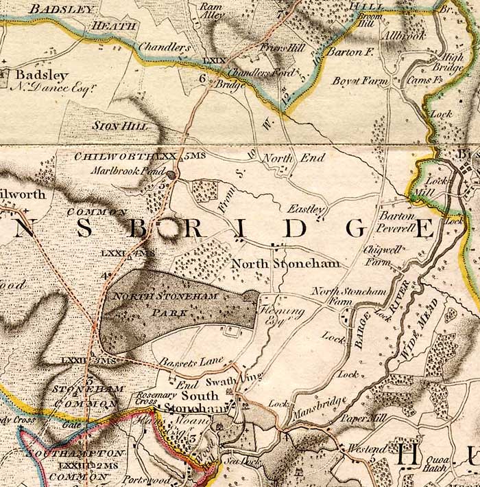
Neighbouring areas are Bassett to the west, North Stoneham to the north, Swaythling to the east & southeast, and Highfield to the southwest.

Bassett Green is divided between two ecclesiastical parishes: North Stoneham & Bassett [1] and Swaythling. [2]

History

Ordnance Survey map of 1935 showing locations of Bassett and Bassett Green. Bassett and Bassett Green locations.png
Ordnance Survey map of 1935 showing locations of Bassett and Bassett Green.
1810 Ordnance Survey map showing location of "Basset", where Bassett Green is located today Bassett 1810.png
1810 Ordnance Survey map showing location of "Basset", where Bassett Green is located today

A family named 'Basset' is known to have lived in South Stoneham in the 15th century and the place name may be from their name. [3] The area broadly occupied by Bassett today was known as Stoneham Common, shown on the 1791 map by Thomas Milne on which 'Bassets Lane' also appears (without any associated village). [4] The village of Bassett appears on a 1810 map, located roughly where Bassett Green Village is today. [5] In the late 18th century it grew as a retreat for rich people outside (and away from civic responsibilities in) the borough of Southampton. By the time of the Ordnance Survey of 1897, Basset had been renamed Bassett Green (with a double 't'), whilst a more westerly area (west of Bassett Wood) was identified as Bassett. [6]

Part of the contract to build Southampton Civic Centre required the construction of social housing. The resulting housing estate was built between Swaythling and Bassett Green and is today known as the Flowers Estate or Flower Roads, as the street names on the estate carry a botanical theme. [7]

Education

Bassett Green is served by Bassett Green Primary School on Honeysuckle Road and Cantell Secondary School on Violet Road. Cantell is a comprehensive secondary school with a specialism in Mathematics and Information and Communication Technology, and is thus officially titled Cantell Mathematics and Computing College. The school has also been largely rebuilt funded through the Private Finance Initiative. [8]

Related Research Articles

Swaythling Human settlement in England

Swaythling is a suburb and electoral ward of the city of Southampton in Hampshire, England. The ward has a population of 13,664.

Samuel Montagu, 1st Baron Swaythling British banker (1832–1911)

Samuel Montagu, 1st Baron Swaythling was a British banker who founded the bank of Samuel Montagu & Co. He was a philanthropist and Liberal politician who sat in the House of Commons from 1885 to 1900, and was later raised to the peerage. Montagu was a pious Orthodox Jew, and devoted himself to social services and advancing Jewish institutions.

Portswood Human settlement in England

Portswood is a suburb and Electoral Ward of Southampton, England. The suburb lies to the north-north-east of the city centre and is bounded by Freemantle, Highfield, Swaythling, St. Denys and Bevois Valley.

Highfield, Southampton Human settlement in England

Highfield is a suburb of Southampton, England. The suburb is situated to the north of the city centre, and is bounded by Southampton Common, Bassett, Swaythling and Portswood. Highfield is home to the main campus of the University of Southampton, which is built on a former brickfield.

The Swaythling and Bassett Covenant of Churches is an ecumenical group made up of the following churches:

Townhill Park Human settlement in England

Townhill Park is a suburb of Southampton, England, bordering Swaythling, Bitterne Park and West End. It is built on land which once belonged to the house which carries the same name.

Brinkworth, Wiltshire Human settlement in England

Brinkworth is a village and civil parish in northern Wiltshire, England. The village lies between Royal Wootton Bassett and Malmesbury, about 1 mile (1.6 km) north of the M4 motorway and 9 miles (14 km) west of Swindon.

Monks Brook River in Hampshire, England

Monks Brook is a river in the English county of Hampshire. It is a tributary of the River Itchen, which it joins at a medieval salmon pool in Swaythling. The brook is formed from seven streams that rise in the chalky South Downs, with the official source of Monks Brook being known as Bucket's Corner. Monks Brook drains a clay catchment of 49 square kilometres (19 sq mi). The brook is designated a main river, which means the operating authority for managing it is the Environment Agency, not the local government authorities for the areas through which the river runs.

Bassett, Southampton Human settlement in England

Bassett is a suburb and electoral ward of the City of Southampton, England. The suburb lies to the north of the city centre and is largely residential, including the University of Southampton's Glen Eyre Halls of residence complex, which houses around 2,100 students. Bassett gives its name to part of the A33 arterial road which links the city centre to the M3, described by Pevsner & Lloyd as "part of the splendid tree-lined route into Southampton from Winchester, London and the north". The highest point in the City of Southampton lies on Bassett Avenue at a height of 82 metres (269 ft) above sea level.

Wessex Lane Halls Halls of residence of the University of Southampton

Wessex Lane Halls is a halls of residence complex owned by the University of Southampton. It is situated in the Swaythling district of Southampton, approximately one mile north-east of the University campus in Highfield.

Herbert Collins British architect

Herbert Collins (1885–1975) was a British architect, born in Edmonton, London. He designed many of the suburban developments in the city of Southampton in the 1920s and 1930s.

South Stoneham House Former manor house and hall of residence in Southampton

South Stoneham House is a Grade II* listed former manor house in Swaythling, Southampton; the former seat of the Barons Swaythling before the family moved to the nearby Townhill Park House. The building is owned by the University of Southampton, and was used as a hall of residence, part of the Wessex Lane Halls complex.

North Stoneham

North Stoneham is a settlement and ecclesiastical parish located in between Eastleigh and Southampton in south Hampshire, England. It was formerly an ancient estate and manor. Until the nineteenth century, it was a rural community comprising a number of scattered hamlets, including Middle Stoneham, North End, and Bassett Green, and characterised by large areas of woodland. The former 1,000-acre North Stoneham Park was redesigned by Capability Brown in the eighteenth century, and was one of the largest ornamental parklands in Hampshire.

South Stoneham was a manor in South Stoneham parish. It was also a hundred, Poor law union, sanitary district then rural district covering a larger area of south Hampshire, England close to Southampton.

St. Marys Church, South Stoneham Church in Hampshire, England

St. Mary's Church, South Stoneham is one of the two remaining medieval churches in the city of Southampton, England. Parts of the building date from the Norman period and the chancel arch is 12th century. The church lies in a secluded position off Wessex Lane, near the north-eastern edge of Southampton and is almost hidden in the Southampton University accommodation campus.

South Stoneham Cemetery

The South Stoneham municipal cemetery, situated off Mansbridge Road, Southampton, was opened in early 1905, with the first burial taking place on 4 February, and was extended in 1927. The South Stoneham Crematorium was located north of the cemetery but demolished during 1973 to make way for the construction of the M27 motorway. The South Stoneham garden of remembrance is now located at the north end of the cemetery.

St Nicolas Church, North Stoneham Church in Hampshire, England

St. Nicolas Church is an Anglican parish church at North Stoneham, Hampshire which originated before the 15th century and is known for its "One Hand Clock" which dates from the early 17th century, and also for various memorials to the famous.

St Michael and All Angels Church, Bassett Church in Southampton, England

St. Michael and All Angels Church, in Bassett, Southampton, is an Anglican parish church which dates from the late 19th century.

Townhill Park House

Townhill Park House is a Grade II listed former manor house between the neighbouring housing estates of Townhill Park in Southampton and Chartwell Green in Eastleigh.

Shamblehurst, also known as Sandhust, was a manor and tithing within the ancient parish of South Stoneham, now in the modern-day Borough of Eastleigh. It had Allington tithing to the north and Botley and Durley parishes to the east.

References

  1. "The Church of England, Parish of North Stoneham & Bassett". Archived from the original on 18 October 2008. Retrieved 1 October 2011.
  2. The Church of England, Parish of Swaythling
  3. Coates: "Old Hampshire Gazetteer" Archived 22 March 2012 at the Wayback Machine Retrieved 2011-09-20
  4. Milne: "Manor of North Stoneham" Retrieved 2011-10-01
  5. Ordnance Survey, 1810
  6. Ordnance Survey, 1897
  7. "10 interesting things you may not know about Southampton". Daily Echo. Retrieved 4 October 2016.
  8. Southampton Schools Archived 13 July 2014 at the UK Government Web Archive