Related Research Articles
Trowlock Island is a residential island in the River Thames 450 metres (490 yd) upstream of Teddington Lock on the non-tidal Kingston reach less than 10 metres from the northern bank, in the London Borough of Richmond upon Thames, England.

Fareham railway station is on the West Coastway Line, situated about 0.62 miles (1 km) from the town of Fareham in Hampshire, England. It is 84 miles 21 chains (135.6 km) down the line from London Waterloo.
Birtley is a hamlet in north Herefordshire, in England. It is situated to the west of Ludlow and Leominster, approximately 16 km (9.9 mi) from both towns. It is part of the civil parish of Lingen.
All Saints is a civil parish in East Devon, Devon, England. It has a population of 498 according to the 2001 census. The parish includes the hamlets of All Saints, Smallridge, Churchill, Alston and Waggs Plot. This area also has one cricket pitch, a primary school, pre-school and a church.

Broadwoodkelly is a village and civil parish in the West Devon district of Devon, England. According to the 2001 census it had a population of 218. The village is situated about 9 miles (14 km) north of Okehampton.
Little Packington is a hamlet and civil parish in the North Warwickshire district of the county of Warwickshire, England, and is sometimes known by the names Packington Piggott or Packington Parva. The hamlet is situated just to the northwest of Great Packington, close to the boundaries of Packington Park and sits on the River Blythe.

Baffins is an administrative district of Portsmouth, England, located on the eastern side of Portsea Island. The district is mainly composed of 1930s housing and a Roman burial ground which now lies beneath the houses of Whitecliffe Avenue. Legend has it that the Roman soldiers who fought bravely for Julius Caesar are buried at this site and are regularly heard in the middle of the night with their war cries. The population of the Baffins ward at the 2011 Census was 15,121.

Bartley Water is a two-branch small river in the New Forest district of Hampshire, England. It drains the north and north-east of the New Forest National Park up to the A31 road, a watershed and two villages against the north-east side of the park.

Bat's Head is a chalk headland on the Dorset coast in southern England. It is located between Swyre Head and Durdle Door to the east, and Chaldon Hill and White Nothe to the west. At the base of the headland is the small Bat's Cave.
Hinton Daubney is a small hamlet in Hampshire, England, located between Catherington and Hambledon. It is the site of one of the earliest recorded sightings of ball lightning.

Horton Heath is a semi-rural village which forms part of the civil parish of Fair Oak and Horton Heath in the borough of Eastleigh in Hampshire, England. The village is about three miles southeast of Eastleigh town centre, and adjoins the village of Fair Oak.

Port Navas Creek, or Porthnavas Creek, is one of seven creeks off the Helford River in Cornwall, England, United Kingdom. It splits into three sections with the village of Porth Navas on the west, Trenarth Bridge in the middle and the eastern one is near Budock Veane. The creek is well known for the oyster beds.

Itchen Ferry village was a small hamlet on the East bank of the River Itchen in Hampshire. The village took its name from the small fishing boats that were also used to ferry foot passengers across the river. An Ordnance Survey map of 1911 (NC/03/17894) shows the village to be situated in the area roughly bounded by Sea Road, Oakbank Road, the River Itchen and the railway line in modern Woolston, but also extending along Sea Road towards Peartree Green on the other side of the railway, which cut the village in half in 1866. Neighbouring streets on that same map, Defender Road, Britannia Road and Shamrock Road have a more structured layout and are clearly part of the Victorian enlargement of Woolston. The same map clearly shows the housing in Itchen Ferry village to have a more random layout. An even older map, of 1842 pins Itchen Ferry village more tightly to the area between Sea Road and Vicarage Road.

The Ordnance Survey (OS) is the national mapping agency for Great Britain. The agency's name indicates its original military purpose, which was to map Scotland in the wake of the Jacobite rising of 1745. There was also a more general and nationwide need in light of the potential threat of invasion during the Napoleonic Wars. Since 1 April 2015, the Ordnance Survey has operated as Ordnance Survey Ltd, a government-owned company, 100% in public ownership. The Ordnance Survey Board remains accountable to the Secretary of State for Science, Innovation and Technology. It was also a member of the Public Data Group.

Trefanny Hill is a hamlet in the parish of Duloe, Cornwall, England, United Kingdom. The hamlet was formerly called Hille or Hill.
In total there are 317 listed buildings in the city of Southampton, of which 15 are Grade I, 20 are Grade II* and the remainder Grade II.
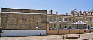
The former offices of Ordnance Survey are situated in London Road, Southampton, close to the junction with The Avenue, and are now part of the city's court complex and are occupied by government agencies. The buildings are Grade II listed.

The Hobbit is a pub in the Bevois Valley area of Southampton, England. Previously the Portswood Hotel, it was named after J. R. R. Tolkien's book The Hobbit in 1989. In 2012 the pub was involved in a legal dispute with Middle-earth Enterprises, a company owned by film producer Saul Zaentz, over its use of the name.
A.F.C. Stoneham is a football club based in Eastleigh, Hampshire, England. They are currently members of the Wessex League Premier Division and play at the Stoneham Football Complex.
Kennack Sands is a beach and sand-dune system on the east coast of the Lizard Peninsula, Cornwall, England, UK.
References
- ↑ Ordnance Survey: Landranger map sheet 196 The Solent & Isle of Wight (Southampton & Portsmouth) (Map). Ordnance Survey. 2015. ISBN 9780319231425.
Areas and suburbs of Southampton | |||||||
|---|---|---|---|---|---|---|---|
| |||||||
| Southampton Itchen |
| ||||||
| Southampton Test | |||||||
| Romsey and Southampton North | |||||||
| |||||||

50°55′52″N1°27′00″W / 50.931°N 1.450°W
| | This Hampshire location article is a stub. You can help Wikipedia by expanding it. |