Ittervoort

Last updated
Ittervoort
Village
Ittervoort, de Sint Margarethakerk RM22872 foto1 2013-04-14 11.58.jpg
St Margaretha Church
Netherlands location map.svg
Red pog.svg
Ittervoort
Location in the Netherlands
2010-NL-P11-Limburg-positiekaart-gemnamen.jpg
Red pog.svg
Ittervoort
Location in the province of Limburg in the Netherlands
Coordinates: 51°10′19″N5°49′16″E / 51.17194°N 5.82111°E / 51.17194; 5.82111
Country Netherlands
Province Limburg
Municipality Leudal
Area
[1]
  Total4.09 km2 (1.58 sq mi)
Elevation
[2]
28 m (92 ft)
Population
 (2021) [1]
  Total1,655
  Density400/km2 (1,000/sq mi)
Time zone UTC+1 (CET)
  Summer (DST) UTC+2 (CEST)
Postal code
6014 [1]
Dialing code 0475
Major roads A2, N273

Ittervoort is a village in the Dutch province of Limburg. It is located in the municipality of Leudal.

Contents

History

The village was first mentioned in 1252 as Itervort, and means "fordable place in the Itterbeek". [3] In 1343, a bridge was built. [4]

The St Margarita Church was built in 1935, however the tower from 1894 was incorporated in the design. [4]

The watermill Schouwsmolen was probably built around 1630 and was used as a grist mill. In 1928, an electro motor was installed, and it went out of service in 1961. Between 2015 and 2016, it was restored and is used to grind corn and generate electricity. [5] [6]

Ittervoort was home to 235 people in 1840. [6] It was a separate municipality until 1942, when it was merged with Hunsel. [7] In 2007, it became part of the municipality of Leudal. [6]

Related Research Articles

<span class="mw-page-title-main">Hunsel</span> Village in Limburg, Netherlands

Hunsel is a village in the south-eastern Netherlands.

<span class="mw-page-title-main">Egmond-Binnen</span> Village in North Holland, Netherlands

Egmond-Binnen is a village in the Dutch province of North Holland. It is a part of the municipality of Bergen, and lies about 8 kilometres (5.0 mi) southwest of Alkmaar.

<span class="mw-page-title-main">Heeswijk</span> Village in North Brabant, Netherlands

Heeswijk is a Dutch village. It is located in the province of North Brabant, in the south of the Netherlands.

<span class="mw-page-title-main">Dommelen</span> Town in North Brabant, Netherlands

Dommelen is a village in southern Netherlands. It is located in the municipality of Valkenswaard, North Brabant. Dommelen derives its name from the little brook Dommel that runs through it. Having its clear water close at hand, Dommelen is mostly known for its beer brewery from which the brand name Dommelsch is derived. Its other main attraction is an old watermill.

<span class="mw-page-title-main">Buggenum</span> Village in Limburg, Netherlands

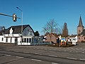
Buggenum is a village in the Dutch province of Limburg. It was a part of the municipality of Haelen until 2007, when it merged into the municipality of Leudal. It lies about 5 km north of Roermond.

<span class="mw-page-title-main">Horn, Netherlands</span> Village in Limburg, Netherlands

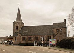
Horn is a village in the Dutch province of Limburg. It is a part of the municipality of Leudal, and lies about 5 km northwest of Roermond.

<span class="mw-page-title-main">Leudal</span> Municipality in Limburg, Netherlands

Leudal is a municipality in the Dutch province of Limburg. It was formed on 1 January 2007 in a merger of the municipalities of Heythuysen, Haelen, Hunsel, and Roggel en Neer.

<span class="mw-page-title-main">Bath, Netherlands</span> Village in Zeeland, Netherlands

Bath is a small village and a former municipality in the Dutch province of Zeeland, lying on the north shore of the Western Scheldt. It is now located in the municipality of Reimerswaal, about 10 km southwest of Bergen op Zoom.

<span class="mw-page-title-main">Hoofdplaat</span> Village in Zeeland, Netherlands

Hoofdplaat is a village in the Dutch province of Zeeland. It is located on the Westerschelde, about 7 km east of Breskens, in the municipality of Sluis.

<span class="mw-page-title-main">Kloetinge</span> Village in Zeeland, Netherlands

Kloetinge is a village in the Dutch province of Zeeland. It is located in the municipality of Goes, on the eastern side of the city.

<span class="mw-page-title-main">Lent, Gelderland</span> Neighbourhood and former village in Nijmegen, Gelderland, Netherlands

Lent is a neighbourhood of Nijmegen and former village in the Dutch province of Gelderland. It is located in the municipality of Nijmegen, about 2 km north of that city, on the north bank of the Waal river.

<span class="mw-page-title-main">Geulle</span> Village in Limburg, Netherlands

Geulle is a village in the Dutch province of Limburg. It is located in the municipality of Meerssen, about 8 km southwest of Geleen.

<span class="mw-page-title-main">Grathem</span> Village in Limburg, Netherlands

Grathem is a village in the Dutch province of Limburg. It is located in the municipality of Leudal, about 10 km west of Roermond.

<span class="mw-page-title-main">Grubbenvorst</span> Village in Limburg, Netherlands

Grubbenvorst is a village in the Dutch province of Limburg. It is located in the municipality of Horst aan de Maas, about 6 km northwest of Venlo.

<span class="mw-page-title-main">Neer</span> Village in Limburg, Netherlands

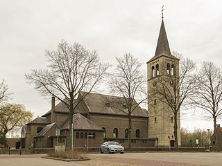
Neer is a village in Limburg, Netherlands. It is located in the municipality of Leudal, on the river Maas about 8 km north of Roermond.

<span class="mw-page-title-main">Neeritter</span> Village in Limburg, Netherlands

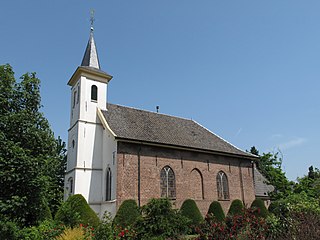
Neeritter is a village in the Dutch province of Limburg. It is located in the municipality of Leudal.

<span class="mw-page-title-main">Nunhem</span> Village in Limburg, Netherlands

Nunhem is a village in the Dutch province of Limburg. It is located in the municipality of Leudal, 1 km north of Haelen.

<span class="mw-page-title-main">Roggel</span> Village in Limburg, Netherlands

Roggel is a village in the Dutch province of Limburg. It is located in the municipality of Leudal.

<span class="mw-page-title-main">Schinveld</span> Village in Limburg, Netherlands

Schinveld is a village in the Dutch province of Limburg. It is located in the municipality of Beekdaelen.

<span class="mw-page-title-main">Lierop</span> Village in North Brabant, Netherlands

Lierop is a village in the Dutch province of North Brabant. It is located in the municipality of Someren, about 7 km south of Helmond.

References

  1. 1 2 3 "Kerncijfers wijken en buurten 2021". Central Bureau of Statistics. Retrieved 24 April 2022.
  2. "Postcodetool for 6262NA". Actueel Hoogtebestand Nederland (in Dutch). Het Waterschapshuis. 24 July 2019. Archived from the original on 21 September 2013. Retrieved 24 April 2022.
  3. "Ittervoort - (geografische naam)". Etymologiebank (in Dutch). Retrieved 24 April 2022.
  4. 1 2 Sabine Broekhoven, & Ronald Stenvert (2003). Ittervoort (in Dutch). Zwolle: Waanders. ISBN   90-400-9623-6 . Retrieved 24 April 2022.
  5. "Schouwsmolen Ittervoort". Kempenbroek molens (in Dutch). Retrieved 24 April 2022.
  6. 1 2 3 "Ittervoort". Plaatsengids (in Dutch). Retrieved 24 April 2022.
  7. Ad van der Meer and Onno Boonstra, "Repertorium van Nederlandse gemeenten", KNAW, 2006. "KNAW > Publicaties > Detailpagina". Archived from the original on 2007-02-20. Retrieved 2009-12-03.