Neeritter

Last updated
Neeritter
Village
Neeritter, de Sint-Lambertuskerk RM22863 IMG 6616 2020-07-19 11.21.jpg
St Lambertus Church
Neeritter wapen.svg
Netherlands location map.svg
Red pog.svg
Neeritter
Location in the Netherlands
2010-NL-P11-Limburg-positiekaart-gemnamen.jpg
Red pog.svg
Neeritter
Location in the province of Limburg in the Netherlands
Coordinates: 51°09′55″N5°48′10″E / 51.16528°N 5.80278°E / 51.16528; 5.80278 Coordinates: 51°09′55″N5°48′10″E / 51.16528°N 5.80278°E / 51.16528; 5.80278
Country Netherlands
Province Limburg
Municipality Leudal
Area
[1]
  Total4.23 km2 (1.63 sq mi)
Elevation
[2]
29 m (95 ft)
Population
 (2021) [1]
  Total1,275
  Density300/km2 (780/sq mi)
Time zone UTC+1 (CET)
  Summer (DST) UTC+2 (CEST)
Postal code
6015 [1]
Dialing code 0475

Neeritter is a village in the Dutch province of Limburg. It is located in the municipality of Leudal.

Contents

History

The village was first mentioned in 1143 as "aliam Iteram que dicitur nova", and means "lower lying stream". [3]

Neeritter developed in the Early Middle Ages along the Itterbeek. [4] In 1584, a semi circular wall was built around the village to protect against the plundering armies during the Eighty Year's War. [5] Between 1614 and 1795, it was part of the Prince-Bishopric of Liège. In 1839, the border between Netherlands and Belgium was defined, and the Borgitter Castle ended up in Kessenich, Belgium. [4]

The Catholic St Lambertus Church is a three aisled church which has 13th century elements. The tower was enlarged in 1842. [4]

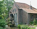
The Armenmolen is watermill. A watermill has been known to exist at the site since 1280. The current mill was built between 1684 and 1687. It went out of service in 1950, and is a residential home since 1972. The water wheel was replaced in 1997. [6]

Neeritter was home to 656 people in 1840. [5] Neeritter was a separate municipality until 1942, when it was merged with Hunsel. [7] In 2007, it became part of the municipality of Leudal. [5]

Related Research Articles

Hunsel Village in Limburg, Netherlands

Hunsel is a village in the south-eastern Netherlands.

Hoogstraten Municipality in Flemish Community, Belgium

Hoogstraten is a municipality located in the Belgian province of Antwerp. The municipality comprises Hoogstraten, Meer, Meerle, Meersel-Dreef, Minderhout and Wortel.

Ottersum Village in Limburg, Netherlands

Ottersum is a village in the Dutch province of Limburg. It is a part of the municipality of Gennep, and lies about 17 km southeast of Nijmegen.

Erp, Netherlands Village in North Brabant, Netherlands

Erp is a village in the southern Netherlands, in the province of North Brabant between 's-Hertogenbosch and Eindhoven. Prior to 1994, Erp was a municipality consisting of the town of Erp and the villages of Boerdonk and Keldonk. In that year, the municipality was merged with the municipality of Veghel to form one municipality under the latter name. The area of the former municipality of Erp has a population of 6,663, while Veghel has a population of 37,655.

Oele Village in Overijssel, Netherlands

Oele is a village in the municipality Hengelo in the Dutch province of Overijssel. It is located south-west of Hengelo, south of the Twentekanaal. The highway A35 and the Provincial road 739|N739 are close to the population centre. Until the creation of the municipality of Hengelo, Oele was part of the richterambt Delden.

Buggenum Village in Limburg, Netherlands

Buggenum is a village in the Dutch province of Limburg. It was a part of the municipality of Haelen until 2007, when it merged into the municipality of Leudal. It lies about 5 km north of Roermond.

Horn, Netherlands Village in Limburg, Netherlands

Horn is a village in the Dutch province of Limburg. It is a part of the municipality of Leudal, and lies about 5 km northwest of Roermond.

Meliskerke Village in Zeeland, Netherlands

Meliskerke is a village in the Dutch province of Zeeland. It is a part of the municipality of Veere, and lies about 8 km west of Middelburg.

Ophemert Village in Gelderland, Netherlands

Ophemert is a village in the Dutch province of Gelderland. It is a part of the municipality of West Betuwe, and lies about 5 km south of Tiel.

Wadenoijen Village in Gelderland, Netherlands

Wadenoijen is a village in the Dutch province of Gelderland. It is a part of the municipality of Tiel, and lies about 4 km west of Tiel.

Almkerk Village in North Brabant, Netherlands

Almkerk is a village in the municipality of Altena, in the Netherlands. It is located about 7 km south of Gorinchem.

Leudal Municipality in Limburg, Netherlands

Leudal is a municipality in the Dutch province of Limburg. It was formed on January 1, 2007 in a merger of the municipalities of Heythuysen, Haelen, Hunsel, and Roggel en Neer.

Grathem Village in Limburg, Netherlands

Grathem is a village in the Dutch province of Limburg. It is located in the municipality of Leudal, about 10 km west of Roermond.

Ittervoort Village in Limburg, Netherlands

Ittervoort is a village in the Dutch province of Limburg. It is located in the municipality of Leudal.

Neer Village in Limburg, Netherlands

Neer is a village in Limburg, Netherlands. It is located in the municipality of Leudal, on the river Maas about 8 km north of Roermond.

Roggel Village in Limburg, Netherlands

Roggel is a village in the Dutch province of Limburg. It is located in the municipality of Leudal.

Nieuw-Vossemeer Village in North Brabant, Netherlands

Nieuw-Vossemeer is a village in the Dutch province of North Brabant. It is located in the municipality of Steenbergen, about 10 km northeast of Bergen op Zoom.

Sprang, Netherlands Village in North Brabant, Netherlands

Sprang is a village in the Dutch province of North Brabant. It is located in the municipality of Waalwijk, about 12 km north of Tilburg.

Tjerkwerd Village in Friesland, Netherlands

Tjerkwerd is a village in Súdwest-Fryslân municipality in the province Friesland of the Netherlands. It had a population of 455 in January 2017.

Erpe Village in Flanders, Belgium

Erpe is a sub-municipality of Erpe-Mere in Flanders on the Molenbeek-Ter Erpenbeek in the Denderstreek in the southeast of East Flanders and belongs to Arrondissement of Aalst. The sub-municipality is bordered by the sub-municipalities of Mere, Ottergem, and Erondegem and the municipalities Lede and Aalst. Erpe has 4903 inhabitants as of 1 January 2003 and an area of 8.28 km2 (3.20 sq mi). The population density is 592/km2 (1,530/sq mi).

References

  1. 1 2 3 "Kerncijfers wijken en buurten 2021". Central Bureau of Statistics. Retrieved 24 April 2022.
  2. "Postcodetool for 6015AA". Actueel Hoogtebestand Nederland (in Dutch). Het Waterschapshuis. Retrieved 24 April 2022.
  3. "Neeritter - (geografische naam)". Etymologiebank (in Dutch). Retrieved 24 April 2022.
  4. 1 2 3 Sabine Broekhoven, & Ronald Stenvert (2003). Neeritter (in Dutch). Zwolle: Waanders. ISBN   90 400 9623 6 . Retrieved 24 April 2022.
  5. 1 2 3 "Neeritter". Plaatsengids (in Dutch). Retrieved 24 April 2022.
  6. "Armenmolen Neeritter". Kempenbroek molens (in Dutch). Retrieved 24 April 2022.
  7. Ad van der Meer and Onno Boonstra, Repertorium van Nederlandse gemeenten , KNAW, 2011.