Roggel

Last updated
Roggel
Rogkel (Limburgish)
Village
Kerkroggel.jpg
Roggel wapen.svg
Netherlands location map.svg
Red pog.svg
Roggel
Location in the Netherlands
2010-NL-P11-Limburg-positiekaart-gemnamen.jpg
Red pog.svg
Roggel
Location in the province of Limburg in the Netherlands
Coordinates: 51°15′45″N5°55′25″E / 51.26250°N 5.92361°E / 51.26250; 5.92361
Country Netherlands
Province Limburg
Municipality Leudal
Area
[1]
  Total16.04 km2 (6.19 sq mi)
Elevation
[2]
29 m (95 ft)
Population
 (2021) [1]
  Total4,295
  Density270/km2 (690/sq mi)
Time zone UTC+1 (CET)
  Summer (DST) UTC+2 (CEST)
Postal code
6088 [1]
Dialing code 0475
Major roads N279

Roggel (Limburgish : Rogkel) is a village in the Dutch province of Limburg. It is located in the municipality of Leudal.

Contents

History

The village was first mentioned in 1230 as Rogle. The etymology is unclear. [3] Roggel developed along the Roggelse Beek. It used to part of the County of Horne. Later it became it part of the Prince-Bishopric of Liège. In 1679, it became an independent heerlijkheid . [4]

The Catholic St Peter Church is a three aisled church which was built in 1477 to replace the 13th century chapel. The latest extension was in 1929. In 1944, the tower was partially blown up and rebuilt in 1946. [4]

Rogger was home to 281 people in 1840. [5] The grist mill Sint-Pieter was built in 1901. After 1953, the mill went out of service. It was sold to the municipality in 1969, and restored in 1976. The wind mill is often in service. [6]

The former municipality of Roggel merged in 1991 with Neer. The new municipality was initially named "Roggel", but changed its name to Roggel en Neer in 1993. [7] In 2007 Roggel en Neer became part of the new municipality of Leudal. [5]

Related Research Articles

<span class="mw-page-title-main">Heythuysen</span> Village in Limburg, Netherlands

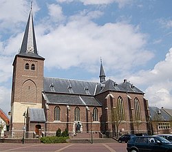
Heythuysen is a town in the south-eastern Netherlands.

<span class="mw-page-title-main">Hunsel</span> Village in Limburg, Netherlands

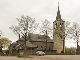
Hunsel is a village in the south-eastern Netherlands.

<span class="mw-page-title-main">Sint Anthonis</span> Village and former municipality in North Brabant, Netherlands

Sint Anthonis is a village and former municipality in the southern Netherlands in the Province of North Brabant. The locals refer to the town as Sint Tunnis. An inhabitant is called a "Sintunnisenaar". The former municipality had a population of 11,691 in 2021. Sint Anthonis, Boxmeer, Cuijk, Grave, and Mill en Sint Hubert merged into the new municipality of Land van Cuijk on 1 January 2022.

<span class="mw-page-title-main">Baexem</span> Village in Limburg, Netherlands

Baexem is a village in the Dutch province of Limburg. It is a part of the municipality of Leudal, and lies about 9 kilometres northwest of Roermond.

<span class="mw-page-title-main">Horn, Netherlands</span> Village in Limburg, Netherlands

Horn is a village in the Dutch province of Limburg. It is a part of the municipality of Leudal, and lies about 5 km northwest of Roermond.

<span class="mw-page-title-main">Sint-Annaland</span> Village in Zeeland, Netherlands

Sint-Annaland is a village in the Dutch province of Zeeland. It is a part of the municipality of Tholen, and lies about 18 km northwest of Bergen op Zoom.

<span class="mw-page-title-main">Leudal</span> Municipality in Limburg, Netherlands

Leudal is a municipality in the Dutch province of Limburg. It was formed on January 1, 2007 in a merger of the municipalities of Heythuysen, Haelen, Hunsel, and Roggel en Neer.

<span class="mw-page-title-main">Sint Pancras</span> Village in North Holland, Netherlands

Sint Pancras is a town in the northwestern Netherlands. It is located in the municipality of Dijk en Waard, North Holland, about 5 km northeast of Alkmaar.

<span class="mw-page-title-main">Grathem</span> Village in Limburg, Netherlands

Grathem is a village in the Dutch province of Limburg. It is located in the municipality of Leudal, about 10 km west of Roermond.

<span class="mw-page-title-main">Neer</span> Village in Limburg, Netherlands

Neer is a village in Limburg, Netherlands. It is located in the municipality of Leudal, on the river Maas about 8 km north of Roermond.

<span class="mw-page-title-main">Nunhem</span> Village in Limburg, Netherlands

Nunhem is a village in the Dutch province of Limburg. It is located in the municipality of Leudal, 1 km north of Haelen.

<span class="mw-page-title-main">Sint Geertruid</span> Village in Limburg, Netherlands

Sint Geertruid is a village in the Dutch province of Limburg. It is located the municipality of Eijsden-Margraten.

<span class="mw-page-title-main">Escharen</span> Dutch village

Escharen is a village in the Dutch province of North Brabant. It is located in the former municipality of Grave. Since 2022 it has been part of the new municipality of Land van Cuijk.

<span class="mw-page-title-main">Moergestel</span> Village in North Brabant, Netherlands

Moergestel is a village in the Dutch province of North Brabant. It is located in the municipality of Oisterwijk, about 7 km East of Tilburg.

<span class="mw-page-title-main">Oploo</span> Village in North Brabant, Netherlands

Oploo is a village in the Dutch province of North Brabant. It is located in the former municipality of Sint Anthonis. Since 2022 it has been part of the new municipality of Land van Cuijk.

<span class="mw-page-title-main">Sintjohannesga</span> Village in Friesland, Netherlands

Sintjohannesga is a village in De Fryske Marren municipality in the province of Friesland, the Netherlands. It had a population of around 1280 in 2017.

<span class="mw-page-title-main">Sint Hubert</span> Village in North Brabant, Netherlands

Sint Hubert is a village in the Dutch province of North Brabant, in the former municipality of Mill en Sint Hubert. Since 2022 it has been part of the municipality of Land van Cuijk.

<span class="mw-page-title-main">Rijkevoort</span> Village in North Brabant, Netherlands

Rijkevoort is a church village with more than 1600 inhabitants. Until 1942, Rijkevoort together with Beugen formed the municipality of Beugen en Rijkevoort. This municipality was then split and Rijkevoort joined the municipality of Wanroij. Since the municipal reorganization of 1 January 1994, most of Rijkevoort belonged to the municipality of Boxmeer. The neighbourhood Rijkevoort-De Walsert was then added to the municipality of Sint Anthonis. Since 2022 Boxmeer and Sint Anthonis have been part of the new municipality of Land van Cuijk.

<span class="mw-page-title-main">Sint-Michielsgestel</span> Place in North Brabant, Netherlands

Sint-Michielsgestel is a village in the municipality of Sint-Michielsgestel, Netherlands.

<span class="mw-page-title-main">Land van Cuijk</span> Municipality in North Brabant, Netherlands

Land van Cuijk is a municipality in the province of North Brabant, Netherlands, formed from the merger of Boxmeer, Cuijk, Sint Anthonis, Mill en Sint Hubert and Grave. The municipality came into existence on 1 January 2022. It belongs to the region of De Peel.

References

  1. 1 2 3 "Kerncijfers wijken en buurten 2021". Central Bureau of Statistics. Retrieved 24 April 2022.
  2. "Postcodetool for 6088AA". Actueel Hoogtebestand Nederland (in Dutch). Het Waterschapshuis. Retrieved 24 April 2022.
  3. "Roggel - (geografische naam)". Etymologiebank (in Dutch). Retrieved 24 April 2022.
  4. 1 2 Sabine Broekhoven, & Ronald Stenvert (2003). Roggel (in Dutch). Zwolle: Waanders. ISBN   90 400 9623 6 . Retrieved 24 April 2022.
  5. 1 2 "Roggel". Plaatsengids (in Dutch). Retrieved 24 April 2022.
  6. "Sint-Petrus". Molen database (in Dutch). Retrieved 24 April 2022.
  7. Ad van der Meer and Onno Boonstra, Repertorium van Nederlandse gemeenten , KNAW, 2011.