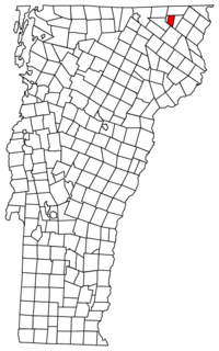
Warren's Gore is a gore in Essex County, Vermont, United States. The population was 2 at the 2020 census, down from 4 at the 2010 census. In Vermont, gores and grants are unincorporated portions of a county which are not part of any town and have limited self-government. Warren's Gore is part of the Berlin, NH–VT Micropolitan Statistical Area.

Chakwal District is in Pothohar Plateau of Punjab, Pakistan. It is located in the north of the Punjab province, Chakwal district is bordered by Khushab to its south, Rawalpindi to its north east, Jhelum to its east, Mianwali to its west and Attock to its north west. The district was created out of parts of Jhelum and Attock in 1985.
The Tl'esqox First Nation is a Tsilhqot'in community located west of the Fraser Canyon in the Chilcotin region of the Canadian province of British Columbia. It is a member of the Carrier-Chilcotin Tribal Council, which includes both Tsilhqot'in and Carrier (Dakelh) communities.
Balkassar is a village and union council, an administrative subdivision, of Chakwal District in the Punjab Province of Pakistan It is part of Chakwal Tehsil. The village gets its name from the Kassar tribe, who also make up the bulk of the population. It is one of a cluster of villages such as Chawli, Dhudial, Mangwal, Bikhari Khurd and Balokassar, which form the tribal homeland of the Kassar tribe. Bal Khan Father name was Kral shandy/ Also known as Kallar sha. Bal Khan has 3 others brothers who lived in Hazara Abottabad area. (1) Mal Khan (2)Jiya Khan (3) Tughlu Khan .the back bone of at least 200 villages in srounding areas.
Bharpur is a village and union council, an administrative subdivision, of Chakwal District in the Punjab Province of Pakistan, it is part of Chakwal Tehsil and is located at 32°51'0N 72°34'0E
Bhilomar is a village and union council, an administrative subdivision, of the Chakwal District in the Punjab Province of Pakistan. It is part of Talagang Tehsil and is located at 32°44'0N 72°26'0E. A majority of the population belongs to the Awan tribe.
Chak Malook is a village and union council, an administrative subdivision, of Chakwal District in the Punjab Province of Pakistan, it is part of Chakwal Tehsil, and is located at 32°58'0N 72°57'0E.
Dalwal is a village and union council, an administrative subdivision, of Chakwal District in the Punjab Province of Pakistan, it is part of Choa Saidan Shah Tehsil and is located at 32°42'0N 72°52'60E
Jaswal is a village and union council, an administrative subdivision, of Chakwal District in the Punjab Province of Pakistan. It is part of Chakwal Tehsil.
Karsal is a village and union council, an administrative subdivision, of Chakwal District in the Punjab Province of Pakistan. It is part of Chakwal Tehsil. Famous Sufi Bari Imam was born in this area. Members of the Kassar tribe make up the bulk of the population. It is one of a cluster of villages such as Chawli, Bhagwal, Dhoke Walana, Dhoke Kassar and Dhoke Chakoi which form the tribal homeland of the Kassar. The Kassar tribe is also belong to Karlal Sardar tribe which is founded by Abottabad Hazara. Bal Khan father name was Kral sha / Kallar sha. Bal khan has 3 other Brothers (1) Mal Khan (2) Jiya Khan (3) Tughlu khan.
Kot Gullah is a village and union council, an administrative subdivision, of Chakwal District in the Punjab Province of Pakistan, it is part of Lawa Tehsil.
Leti is a village in the Punjab Province of Pakistan. The name is derived from a shallow water stream.
Mangwal is a village and union council, an administrative subdivision, of Chakwal District in the Punjab Province of Pakistan, it is part of Chakwal Tehsil and is located at 33°6'30N 72°49'32E.
Odherwal is a village and union council, an administrative subdivision, of Chakwal District in the Punjab Province of Pakistan, it is part of Chakwal Tehsil and is located at 32°56'0N 72°48'0E.
Tehi is a village and one of the 23 union councils of Talagang Tehsil, Chakwal District in the Punjab Province of Pakistan.

Batié is a department or commune of Noumbiel Province in southeastern Burkina Faso. Its capital is the town of Batié.

Karuli, or Karuli Piran, is a village of Kallar Kahar Tehsil, Chakwal District, Pakistan. It is located in a salt range near Motorway M-2.
Wallana is a village in the Punjab province of Pakistan. It is located at 32°53'0N 72°37'0E with an altitude of 511 metres.
Ratta is a village in the Kallar Kahar Tehsil District Chakwal Punjab province of Pakistan. It is located at 32°51'0N 72°41'0E with an altitude of 520 metres .Now called by People Ratta Sharif
Rahna is a village in the Punjab province of Pakistan. It is located at 32°53'0N 72°42'0E with an altitude of 516 metres.


