
Fulton County Airport, also known as Charlie Brown Field or Brown’s Field, is a county-owned, public-use airport in Fulton County, Georgia, United States. It is located six nautical miles west of the central business district of Atlanta. The airport's name comes from the nickname of former Atlanta politician Charles M. Brown, who served on the city council and county commission during the 1960s. It is also called Charlie Brown Airport or Brown Field. On the radio, however, it is referred to as "County Tower" or "County Ground".

DeKalb–Peachtree Airport is a county-owned, public-use airport in DeKalb County, Georgia, United States. The airport is located in the city of Chamblee, just northeast of Atlanta. It is also known commonly as Peachtree–DeKalb Airport, or simply PDK. Other names include Peachtree Airport, DeKalb Airport, or DeKalb County Airport. ASOS weather reports are produced 24 hours per day as "Chamblee". It has airline service with Ultimate Air Shuttle to Cincinnati and Southern Airways Express to Memphis and Destin.
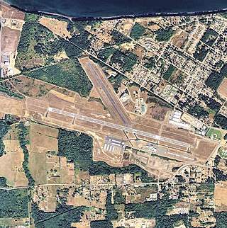
William R. Fairchild International Airport is a public airport located within the city limits of Port Angeles in Clallam County, Washington, United States. It is 3.5 miles northwest of the central business district of Port Angeles, near the Strait of Juan de Fuca. The airport is owned by the Port of Port Angeles.
North Palm Beach County Airport, also known as North County Airport, is an uncontrolled (non-towered) general aviation airport located 12 nautical miles (22 km) northwest of West Palm Beach off the Bee Line Highway in Palm Beach Gardens, Florida. The airport is owned by Palm Beach County and operated by the Palm Beach County Airports Department.

Jackson County Airport, also known as Reynolds Field, is a county-owned, public-use airport located two nautical miles (3.7 km) west of the central business district of Jackson, in Jackson County, Michigan, United States. It is a class D airport with operating control tower. It is included in the Federal Aviation Administration (FAA) National Plan of Integrated Airport Systems for 2017–2021, in which it is categorized as a regional general aviation facility.

Ashland Municipal Airport is two miles east of Ashland, in Jackson County, Oregon. The National Plan of Integrated Airport Systems for 2011 through 2015 categorized it as a general aviation facility.
Pittsburgh Northeast Airport is a privately owned, public use airport in Allegheny County, Pennsylvania, United States. The airport is located 12 nautical miles north-northeast of the central business district of Pittsburgh, in West Deer Township. The airport is located a few miles north of Pittsburgh Mills shopping mall.

Marianna Municipal Airport is an airport in Marianna, Jackson County, Florida, 5 miles (8.0 km) northeast of Downtown Marianna. The Federal Aviation Administration (FAA)'s National Plan of Integrated Airport Systems for 2009–2013 categorized it as a general aviation airport. It was formerly Graham Air Base.
St. Elmo Airport is a public-use airport located two nautical miles west of the central business district of St. Elmo, in Mobile County, Alabama, United States. It is included in the FAA's National Plan of Integrated Airport Systems for 2011–2015, which categorized it as a general aviation facility.

Foley Municipal Airport is a city-owned public-use airport located three nautical miles northwest of the central business district of Foley, a city in Baldwin County, Alabama, United States.

Scottsboro Municipal Airport, also known as Word Field, is a city-owned public-use airport located two nautical miles (3.7 km) northeast of the central business district of Scottsboro, a city in Jackson County, Alabama, United States. According to the FAA's National Plan of Integrated Airport Systems for 2009–2013, it is categorized as a general aviation facility.

North Pickens Airport is a county-owned public-use airport in Pickens County, Alabama, United States. It is located one nautical mile north of the central business district of Reform, Alabama. The airport is included in the FAA's National Plan of Integrated Airport Systems for 2011–2015, which categorized it as a general aviation facility.

Roy E. Ray Airport is a privately owned, public-use airport located three nautical miles northeast of the central business district of Bayou La Batre, a city in Mobile County, Alabama, United States.
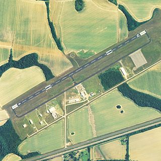
Freeman Municipal Airport is a public use airport located two nautical miles (4 km) southwest of the central business district of Seymour, a city in Jackson County, Indiana, United States. It is owned by the Seymour Airport Authority. This airport is included in the National Plan of Integrated Airport Systems for 2021–2025, which categorized it as a general aviation facility.

Jackson County Airport is three miles northeast of Jefferson, in Jackson County, Georgia, United States. It covers 181 acres (73 ha) at an elevation of 951 feet ; its single runway, 17/35, is 5,210 by 75 feet asphalt.
Jackson County Airport is a county-owned, public-use airport located 3 nautical miles northeast of the central business district of Gainesboro, in Jackson County, Tennessee, United States.
Jackson County Airport is a county-owned, public-use airport located six nautical miles southwest of the central business district of Ravenswood, in Jackson County, West Virginia, United States.
Roy Wilcox Airport is a public use airport in Washington County, Alabama, United States. The airport is owned by the town of Chatom and located three nautical miles (6 km) east of its central business district.
Stevenson Airport is a city-owned public-use airport located two nautical miles southwest of the central business district of Stevenson, a city in Jackson County, Alabama, United States.
Jackson Municipal Airport is a city-owned public-use airport located two nautical miles north of the central business district of Jackson, a city in Jackson County, Minnesota, United States. It is included in the FAA's National Plan of Integrated Airport Systems for 2011–2015, which categorized it as a general aviation facility.
