
Porto Alegre is the capital and largest city of the Brazilian state of Rio Grande do Sul. Its population of 1.332.845 inhabitants (2022) makes it the 11th-most populous city in the country and the center of Brazil's fifth-largest metropolitan area, with 4,405,760 inhabitants (2010). The city is the southernmost capital city of a Brazilian state.

Rio Grande do Sul is a state in the southern region of Brazil. It is the fifth-most populous state and the ninth-largest by area. Located in the southernmost part of the country, Rio Grande do Sul is bordered clockwise by Santa Catarina to the north and northeast, the Atlantic Ocean to the east, the Uruguayan departments of Rocha, Treinta y Tres, Cerro Largo, Rivera, and Artigas to the south and southwest, and the Argentine provinces of Corrientes and Misiones to the west and northwest. The capital and largest city is Porto Alegre. The state has the highest life expectancy in Brazil, and the crime rate is relatively low compared to the Brazilian national average. Despite the high standard of living, unemployment is still high in the state, as of 2017. The state has 5.4% of the Brazilian population and it is responsible for 6.6% of the Brazilian GDP.
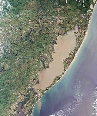
Lagoa dos Patos is the largest lagoon in Brazil and the largest coastal lagoon in South America. It is located in the state of Rio Grande do Sul, southern Brazil. It covers an area of 10,100 km2 (3,900 sq mi), is 180 miles (290 km) long and has a maximum width of 44 miles (71 km).
Gravataí is a Brazilian municipality near Porto Alegre at the Rio Grande do Sul State. Its population is approximately 280,000 people, making it the sixth most populous city in the state.

Canoas is a municipality in the state of Rio Grande do Sul, Brazil, forming part of the Greater Porto Alegre area. It is the largest municipality of the metropolitan region of Porto Alegre and the third largest municipality of Rio Grande do Sul. Officially declared a city on June 27, 1939, after its separation from São Sebastião do Caí and Gravataí, Canoas derives its name from the historical crafting of canoes in the area. It is the second largest city in the Porto Alegre metropolitan area, with the third-largest population and the third-highest GDP in the state. It is also ranked as the 79th most populous city in Brazil.

Guaíba is a city located in the Metropolitan Porto Alegre of Porto Alegre, in the Brazilian state of Rio Grande do Sul. The city is on the shores of the Guaíba Lake.
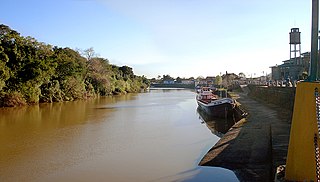
São Sebastião do Caí is a city near Porto Alegre in the Brazilian state of Rio Grande do Sul. It has a population of about 25,000 inhabitants. The principal university is the University of Caxias do Sul, often abbreviated as UCS. Through the middle of the city runs the river Caí, whose source is in the mountains of São Francisco de Paula, and which empties into Guaíba Lake. The city was founded on May 1, 1875. Like many towns in the state which were settled by German-speaking Europeans in the 19th century, the German language is still present in daily family and community life, if not as much in the public sphere since World War II.

Viamão is a city in Rio Grande do Sul, Brazil. In size it is the largest municipality in the metropolitan region of Porto Alegre and the seventh most populous in the state.
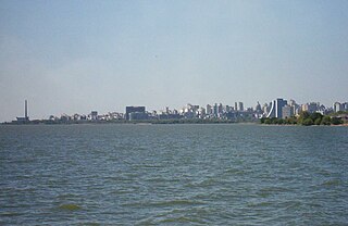
Guaíba is a major water body in Rio Grande do Sul, the southernmost state of Brazil. It is commonly referred to either as a "river" or as a "lake". The Jacuí River, the Sinos River, the Gravataí River and the Caí River empty into Guaíba from the north, which in its turn empties into the Lagoa dos Patos, the largest lagoon in South America further down south. The body of water covers 496 square kilometres (192 sq mi) in total.

The Jacuí River is a river in Rio Grande do Sul state of southern Brazil. The Jacuí empties into the Guaíba River, an estuarine arm of the Lagoa dos Patos, a large coastal lagoon connected to the Atlantic Ocean.

Charqueadas is a municipality in the state of Rio Grande do Sul, Brazil. It is located on the southern side of the Jacuí River, in the eastern-central part of the state. The city is 57 km (35 mi) west of the state capital and most populous city, Porto Alegre, and belongs to its metropolitan area. The area of the municipality is 214.80 km2 (82.93 sq mi), and it have a population of 41,258, making it the largest municipality by population in the region. It borders to the south Arroio dos Ratos, to the north Triunfo, to the east Eldorado do Sul and to the west São Jerônimo.
The Caí River is a river of Rio Grande do Sul state in southern Brazil. It is a tributary of the Jacuí River, just above the junction with the Guaíba.
Banhados do Delta do Jacuí Biological Reserve is a biological reserve in the Jacuí River delta in Rio Grande do Sul, Brazil.

Centro Histórico is a neighborhood of the city of Porto Alegre, the state capital of Rio Grande do Sul in Brazil.

Marcílio Dias is a neighbourhood (bairro) in the city of Porto Alegre, the state capital of Rio Grande do Sul, in Brazil. It was created by Law 2022 from December 7, 1959, but had its limits modified by Law 6218 from October 17, 1988, which originated the Farrapos and Humaitá neighbourhoods.

Arroio Dilúvio is a brook (arroio) in Porto Alegre, Rio Grande do Sul, Brazil, that flows in areas with high population density. It was or still is known by other names: Riacho Ipiranga, Arroio da Azenha, Riacho or Riachinho and even Arroio do Sabão, this being the current name of the stream that gives it its most distant source.
A physiographic region located in Rio Grande do Sul, the Central Depression, as the name suggests, is in the central part of the state, between the Planalto Médio and the Serra do Sudeste. It comprises the major municipalities of Porto Alegre, Gravataí, Santa Maria, Guaíba, Taquari, Canoas, Cachoeira do Sul, Santa Cruz do Sul, and covers an area of 31,778 km².

The Mauá Pier is a section of the river port located in the Brazilian city of Porto Alegre, in the state of Rio Grande do Sul. It is situated on the Navegantes Canal, upstream of Lake Guaíba, and is part of the Jacuí Delta.
Mauá Wall is a flood protection structure located between Mauá Pier and Mauá Avenue, in the Historic Center of Porto Alegre, Rio Grande do Sul.


