Cedar City Regional Airport is two miles northwest of Cedar City, in Iron County, Utah. It is owned by the Cedar City Corporation. Airline flights are subsidized by the Essential Air Service program.

Merle K. (Mudhole) Smith Airport is a state-owned public-use airport located 11 nautical miles southeast of the central business district of Cordova, a city in the Chugach Census Area of the U.S. state of Alaska which has no road access to the outside world. Airline service is subsidized by the Essential Air Service program.

Bessemer Airport is a city-owned public-use airport located three nautical miles southeast of the central business district of Bessemer, a city in Jefferson County, Alabama, United States. According to the FAA's National Plan of Integrated Airport Systems for 2009–2013, it is categorized as a reliever airport for the Birmingham-Shuttlesworth International Airport.
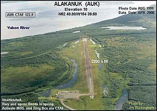
Alakanuk Airport is a state-owned public-use airport located 2 nautical miles (3.7 km) west of the central business district of Alakanuk, a city in the Kusilvak Census Area of the U.S. state of Alaska.

Henderson Executive Airport is a public use government airport located in Henderson, Nevada, 13 miles south of Las Vegas, in Clark County, Nevada. The airport is owned by the Clark County Commission and operated by the Clark County Department of Aviation. The FAA's National Plan of Integrated Airport Systems for 2009-2013 categorized it as a reliever airport.
Egegik Airport is a city-owned, public-use airport serving Egegik, a city in the Lake and Peninsula Borough of the U.S. state of Alaska. Scheduled passenger service is available at this airport.
Beluga Airport is a private use airport in Beluga, in the Kenai Peninsula Borough of the U.S. state of Alaska. It is privately owned by ConocoPhillips.

Palatka Municipal Airport, also known as Lieutenant Kay Larkin Field, is a city-owned, public-use airport located two nautical miles (4 km) northwest of the central business district of Palatka, a city in Putnam County, Florida, United States. It is included in the National Plan of Integrated Airport Systems for 2011–2015, which categorized it as a general aviation facility.

Abbeville Municipal Airport is a city-owned, public-use airport located three nautical miles north of the central business district of Abbeville, a city in Henry County, Alabama, United States. It is the only airport that serves the city of Abbeville.
Albertville Regional Airport, also known as Thomas J. Brumlik Field, is a city-owned, public-use airport located three nautical miles southwest of the central business district of Albertville, in Marshall County, Alabama, United States. It was formerly known as Albertville Municipal Airport.
Perryville Airport is a state-owned, public-use airport located one nautical mile southwest of the central business district of Perryville, in the Lake and Peninsula Borough of the U.S. state of Alaska. Scheduled airline service to King Salmon Airport is provided by Peninsula Airways (PenAir).

Beaver Municipal Airport is a public use airport in Beaver County, Utah, United States. It is owned by the city of Beaver and located four nautical miles southwest of its central business district. This airport is included in the National Plan of Integrated Airport Systems for 2011–2015, which categorized it as a general aviation facility.

Naknek Airport is a state-owned, public-use airport located one nautical mile north of the central business district of Naknek, in the Bristol Bay Borough of the U.S. state of Alaska.
Tooele Valley Airport, also known as Bolinder Field, is a public use airport in Erda, Tooele County, Utah, United States. It is owned by the Salt Lake City Department of Airports and is located five nautical miles (9.26 km) northwest of the central business district of the City of Tooele. According to the FAA's National Plan of Integrated Airport Systems for 2009–2013, it is categorized as a general aviation airport.
Shelbyville Municipal Airport is a public use airport located four nautical miles (7 km) northwest of the central business district of Shelbyville, in Shelby County, Indiana, United States. The airport is owned by the city of Shelbyville and is controlled by the mayor and an appointed Board of Commissioners. According to the FAA's National Plan of Integrated Airport Systems for 2009–2013, it was classified as a general aviation airport.
Huntington Municipal Airport is a city-owned, public-use airport located three nautical miles southeast of the central business district of Huntington, a city in Huntington County, Indiana, United States. According to the FAA's National Plan of Integrated Airport Systems for 2009–2013, it was classified as a general aviation airport.
Independence Municipal Airport is a city-owned public-use airport located three nautical miles (6 km) southwest of the central business district of Independence, a city in Buchanan County, Iowa, United States. As per the FAA's National Plan of Integrated Airport Systems for 2009-2013, it is classified as a general aviation airport.
Green River Municipal Airport is a public airport five miles southwest of Green River, in Emery County, Utah. It is owned by the Green River City Corp. The FAA's National Plan of Integrated Airport Systems for 2009–2013 called it a general aviation airport.

St. George Regional Airport is a city-owned airport in St. George, Washington County, Utah.
Panguitch Municipal Airport is a public use airport located three nautical miles (6 km) northeast of the central business district of Panguitch, a city in Garfield County, Utah, United States. It is owned by the Panguitch City Corp. This airport is included in the National Plan of Integrated Airport Systems for 2011–2015, which categorized it as a general aviation facility.