Sullurupeta is a town in Tirupati district of Andhra Pradesh, India. It is a municipality and the headquarters of Sullurupeta mandal and Sullurupeta revenue division. It serves as a gateway to Satish Dhawan Space Centre(SDSC) at Sriharikota.

Kovur is a village in Nellore district of the Indian state of Andhra Pradesh. The village is also the headquarters of the Kovur Mandal and Assembly Constituency. It is located in Kovur mandal of Nellore revenue division. It forms a part of Nellore Urban Development Authority. The poet "Thikkanna" was born in this place.
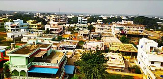
{{Infobox settlement | name = Kandukur | native_name = | native_name_lang = | other_name = | settlement_type = Town | image_skyline = | image_alt = | image_caption = | nickname = | pushpin_map = India Andhra Pradesh#India | pushpin_label_position = right | pushpin_map_alt = | pushpin_map_caption = Location in Andhra Pradesh, India | pushpin_mapsize = 200 | coordinates = 15.2166650°N 79.9042°E | subdivision_type = Country | subdivision_name = India | subdivision_type1 = State | subdivision_type2 = District | subdivision_name1 = Andhra Pradesh | subdivision_name2 = SPSR Nellore | established_title = | established_date = | founder = | named_for = | government_type = Municipal Council | governing_body = Kandukuru Municipal Council | leader_title1 = Chairman | leader_name1 = Vacant | leader_title2 = Deputy Chairman | leader_name2 = Vacant | leader_title3 = MLA | leader_name3 = Inturi Nageswar Rao (TDP) | leader_title4 = MP | leader_name4 = [[Vemireddy Prabakar reddy]{TDP}]] | unit_pref = Metric | area_footnotes = | area_total_km2 = 33.06 | area_rank = | elevation_footnotes = | elevation_m = | population_total = 57,246 | population_as_of = 2011 | population_footnotes = | population_density_km2 = auto | population_rank = 26th (Towns in AP) | population_demonym = | timezone1 = IST | utc_offset1 = +5:30 | postal_code_type = PIN | postal_code = 523 105 | registration_plate = | website = | footnotes = | image_map = | map_alt = Dynamic map of village | map_caption = Dynamic map }} Kandukur or Kandukuru is a town in SPSR Nellore district of the Indian state of Andhra Pradesh. It is a municipality and the headquarters of Kandukur mandal as well as Kandukur revenue division. Kandukur Mandal is located at the south-east side of the Prakasam District having geographical area around 225 km2.There is only 1 city in the Kandukur Mandal, which is Kandukur Municipality having an area of 37.63 km2.

Nelli-marla is a census town in Vizianagaram district of the Indian state of Andhra Pradesh. It is in Nellimarla mandal of Vizianagaram revenue division.
Duttalur or Duthalur is a village and a mandal in Nellore district in the state of Andhra Pradesh in India.
Kaligiri is a town in Nellore district in the Indian state of Andhra Pradesh it is the mandal headquarters of Kaligiri Mandal in India.
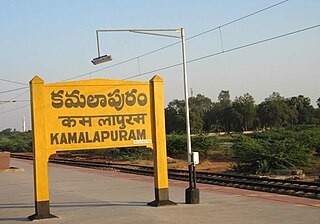
Kamalapuram is a Town in YSR Kadapa district of the Indian state of Andhra Pradesh. It is located in Kamalapuram mandal of Kadapa revenue division and is the Thaluka headquarter of Kamalapuram assembly constituency.
Sakhavaram is a village in Nellore District, Andhra Pradesh, India.
Nellore mandal is one of the 46 mandals in Nellore district of the state of Andhra Pradesh, India. Its headquarters are located at Nellore. The mandal is bounded by Sangam, Butchireddipalem, Indukurpet, Kovur, Podlakur, Thotapalligudur, Venkatachalam and Muthukur mandals.
Naidupeta mandal is one of the 34 mandals in Tirupati district of the state of Andhra Pradesh, India. Its headquarters are located at Naidupeta. The mandal is bounded by Balayapalle, Ojili, Pellakur, Doravarisatram and Chittamur mandals.
Gudur mandal is one of the 34 mandals in Tirupati district of the state of Andhra Pradesh, India. Its headquarters are located at Gudur. The mandal is situated on the coast of Bay of Bengal, bounded by Sydapuram, Manubolu, Balayapalle, Ojili and Chillakur mandals. It is a part of Gudur revenue division.
Kota mandal is one of the 34 mandals in Tirupati district of the state of Andhra Pradesh in India. Its headquarters are located at Kota. The mandal is bounded by Muthukur mandal, Chillakur, Ojili, Chittamur, Vakadu mandals and it also borders Nellore district.
Venkatagiri mandal is one of the 34 mandals in Tirupati district in the Indian state of Andhra Pradesh. It is a part of Gudur revenue division.
Kandukuru mandal is one of the 38 mandals in Nellore district of the Indian state of Andhra Pradesh. Its headquarters are located at Kandukuru. This mandal is part of Kandukur revenue division.
Lingasamudram mandal is one of the 38 mandals in Nellore district of the Indian state of Andhra Pradesh. Its headquarters are located at Lingasamudram. The mandal is bounded by .This mandal is located at Kandukur revenue division.
Kavali mandal is one of the 38 mandals in Nellore district of the Indian state of Andhra Pradesh. Its headquarters are located at Kavali. The mandal is bounded by .This mandal is located at Kavali revenue division.
Chillakur mandal is one of the 34 mandals in Tirupati district in the Indian state of Andhra Pradesh. It is a part of Gudur revenue division and is headquartered at Chillakur.
Atmakur mandal is one of the 38 mandals in Nellore district of the Indian state of Andhra Pradesh. Its headquarters are located at Atmakur. The mandal is located at Atmakur revenue division.
Chittamur mandal is one of the 34 mandals in Tirupati district in the Indian state of Andhra Pradesh. It is a part of Gudur revenue division with its headquarters at Chittamur.
Vavveru is a village in Buchireddypalem Mandal, Nellore District, Andhra Pradesh, India. It is located on the eastern shore of Kanigiri Reservoir, about 13 kilometres northwest of the district seat Nellore and 5 kilometres north of the mandal seat Buchireddypalem. According to the 2011 India Census, the village has a population of 33,803.

